A brief history of research
Preliminary research in several disciplines first signalled that agriculture had a long antiquity in the highlands of New Guinea. Ethnobotanical research in the Pacific suggested New Guinea was a centre of plant domestication.[983] Palaeoecological research documented major transformations and degradation of the lower montane forest in parts of the highlands by c.
5,000-4,000 years ago.[984] Archaeological excavations at other wetlands in the upper Wahgi valley uncovered evidence of agricultural practices, including wooden digging sticks and ditches, that were over 2,000 years old.[985]The potential of Kuk to unravel the history of agriculture in the highlands was first indicated by finds unearthed during modern drainage of the wetland in 1969; subsequently, between 1972 and 1977, six major field seasons of multidisciplinary research were directed by Jack Golson, with Philip Hughes as codirector from 1974.[986] Over 180 trenches or open area excavations were completed, and archaeological and stratigraphic recording occurred along more than 15 km of newly dug plantation drain (Figure 17.1). Small-scale fieldwork
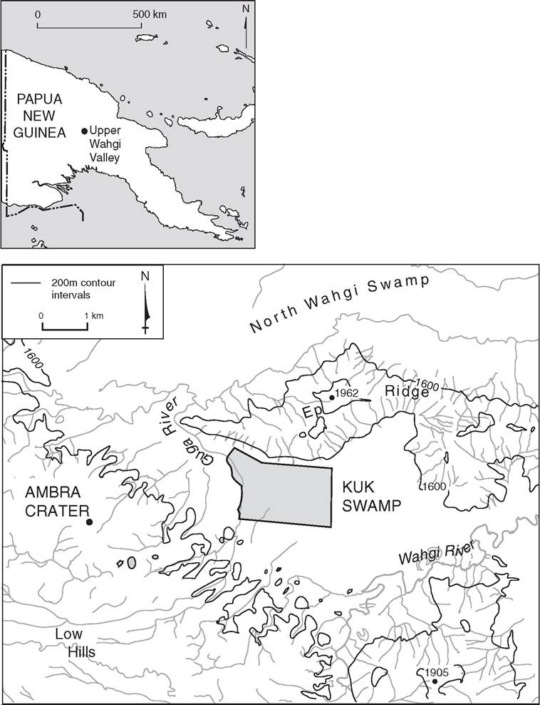
Figure 17.1 Maps showing (above) the location of Kuk in Papua New Guinea; and (below) Kuk Swamp within its landscape setting.
and site visits occurred until the Station was effectively abandoned by the national government in 1990. Archaeology at Kuk was complemented by what was at the time an innovative range of approaches, including agronomy; the application of macrofossils (seeds and wood) and microfossils (phytoliths, pollen, and microcharcoal) to archaeobotany and palaeoecology; thermoluminescence, ESR, and radiocarbon dating; and a range of stratigraphic investigations.[987] [988]
The original claims for early agriculture derived from these investigations were not widely accepted, due to limited publication of the archaeological evidence; uncertainties regarding the mode of formation and function of archaeological features associated with early agricultural activities; a lack of palaeoecological evidence contemporary with early agricultural remains; and limited archaeobotanical evidence for the presence, use, and cultivation of plants.11 As a result, renewed multidisciplinary research on early agriculture was initiated at Kuk in 1997 to clarify issues arising from previous work.
The archaeological excavations undertaken at Kuk in 1998 and 1999 were designed to determine the form and function of features and palaeosurfaces associated with the early periods of manipulation and drainage of the wetland, namely those predating c. 2,500 years ago. Analyses undertaken on associated artefacts and soil/sediment samples comprised:
• Radiocarbon dating (conventional and AMS) to improve the accuracy and resolution of the agricultural chronology.
• Intensive palaeoecological analyses (paired microcharcoal, phytolith, and pollen analyses, as well as entomology) to determine environmental
transformations associated with former practices, to differentiate anthropic from climatic components of vegetation history, and to obtain ecological signatures for key archaeological features and periods.
• Archaeobotanical analyses, including phytolith and starch granule residues from stone artefacts, to determine the presence, use, and cultivation of food plants.
• Mixed-method stratigraphic analyses (X-radiography, X-ray diffraction, and soil micromorphology) to characterize sedimentation and soil formation processes through time.[989]
Although archaeological excavations have not occurred at Kuk since 1999, multidisciplinary research continues on previously collected samples. These initiatives are designed to provide palaeoecological and use-wear records for periods of drainage during the last 2,500 years that are comparable to those established for earlier periods. Archaeobotanical investigations also continue on macrobotanical samples, including aroid seeds (histology and microscopy), and on tuber fragments (aDNA, AMS, and starch grain analysis).
Stratigraphy
The stratigraphic model for Kukwas developed using a suite of analyses.[990] The mixed-method strategy was designed to disentangle and reconstruct a hierarchy of site formation processes for different episodes of wetland inundation, tephra deposition, and soil formation during drier periods or following drainage for cultivation. The superimposition of depositional (sedimentary) and pedogenic (soil formation) processes was reconstructed for different stratigraphic units, with particular reference to periods of wetland manipulation and abandonment during the early and mid-Holocene (Figure 17.2).
Distinct stages in the development of each stratigraphic unit and archaeological context were characterized and can be summarized in a generalized three-step model:
1. Original deposition - whether aeolian (tephra), alluvial (silts and clays), or autogenic (peat) - represented by inherited sedimentary stratification.
2. Anthropic and pedogenic alteration of the sediment and formation of archaeological deposits and palaeosols, respectively, including those associated with wetland manipulation, drainage, and cultivation.
3. Modification of archaeological contexts prior to and following burial through repeated periods of waterlogging and soil formation.
An ability to identify and characterize post-depositional modifications has proven essential for establishing the reliability of different contexts for archaeobotany, dating, and palaeoecology.
Outline of Conceptualjramework
Numerous conceptual frameworks have been developed and applied to understand agricultural history at Kuk. Golson's early interpretations emphasized ecology and efficiency and were expressed in neo-Boserupian terms, whereas later interpretations drew on Modjeska and Gorecki to develop more socially and politically oriented perspectives.[991] Subsequent interpretations have variously interrogated the evidence using insights derived from human ecology and post-processual thought.[992]
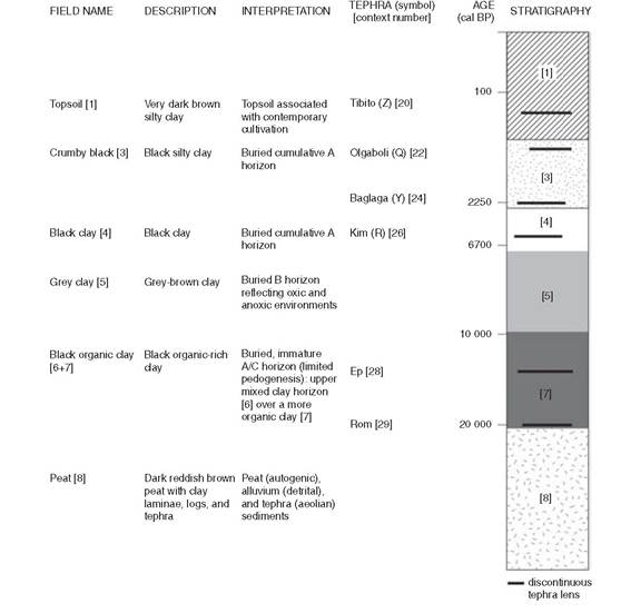
Figure 17.2 Archaeostratigraphic model for the stratigraphy at Kuk.
At Kuk, agriculture in the past has been inferred using a triangulation method. In other words, the identification of agriculture is not dependent upon one type of evidence; rather, it is situated using multiple lines of evidence. These comprise archaeological remains associated with plant cultivation; archaeobotanical evidence for the presence, use, and cultivation of plants; and palaeoenvironmental records (palaeoecology, geomorphology, and sedimentology) documenting landscape changes accompanying the emergence and transformation of agriculture through time (Figure 17.3).
An evolving methodology focused on practices has been built upon this multidisciplinary approach. Practices are human actions in the past, including habitual modes of behaviour and dispositions, as well as individual idiosyncrasies.[993] Evidence of practices accumulates and becomes inscribed
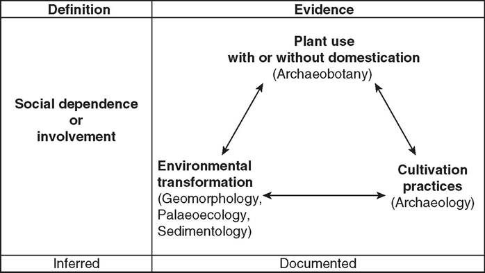
Figure 17.3 Schematic depiction of the conceptual and methodological bases for the interpretation of early agriculture in New Guinea.
within a landscape through time. The landscape is the appropriate scale of analysis and interpretation because it encapsulates everyday experience; in other words, it is a meaningful spatial scale for past human experience. Furthermore, the variability in plant exploitation practices across Papua New Guinea today, if symptomatic of the past, suggests that a landscape or regional approach to investigating agriculture should be adopted in order to avoid bringing together evidence of practices from different parts of the island that never actually co-occurred in the past.[994]
A chronology of practices can then be assembled for a landscape. Co-occurring practices can be brought together, or ‘bundled', to interpret different forms of plant exploitation in the past (Figure 17.4). Perhaps the most crucial element of these reconstructions is archaeological and pedogenic evidence of former cultivation and archaeobotanical evidence of cultivated plants. Without this evidential grounding, the interpretation of cultivation and agriculture in the past, whether based solely on palaeoecology or on phenotypically ‘domesticated' plant fossils, is largely inferential.
Years (cal BP)
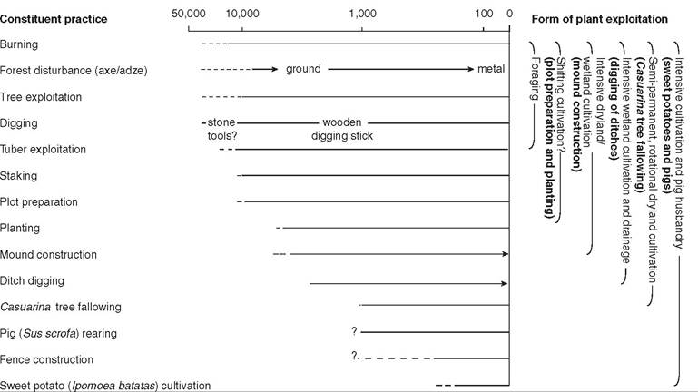
Figure 17.4 Chronology of practices and forms of plant exploitation in the upper Wahgi valley.