Chronology of plant exploitation
Life during the Pleistocene
People arrived in New Guinea at least 50,000-45,000 years ago, with evidence for occupation of the highlands from that time.[995] The colonists are presumed to have engaged in generalized patterns of behaviour, including landscape and plant management using fire; broad spectrum plant exploitation encompassing tree (nuts, fruits, and possibly forms of sago) and tuber exploitation; broad spectrum animal exploitation; and high degrees of mobility across land and presumably water.
Early inhabitants of the upper Wahgi valley found a forested valley floor, with climatically induced fluctuations in the relative dominance of upper and lower montane forest species.At Kuk, pollen records indicate burning, opening of the forest, and establishment of grassland patches for at least the last 20,000 years (Figure 17.5).[996] Although fires can be caused by lightning, an increasing part of the signal can be attributed to burning by people. More definitive traces of past human presence are represented by a possible hearth on the wetland margin dated to c. 30,000 years ago.
Early anthropic burning occurred from c. 40,000 cal bp in the Owen Stanley Ranges to the east and from c. 32,000 cal bp in the Baliem valley to the west.[997] Indeed, burning during the Pleistocene has been recorded in all the major intervening inter-montane valleys along the highland spine of the island: Telefomin, Haeapugua, and Wahgi valley; while similar records of burning are more limited in lowland New Guinea and in island Melanesia. [998]
Recurrent accounts portray pre-agricultural occupation of the highlands in the Pleistocene as temporary and based on hunting and the exploitation of seasonally producing Pandanus spp.[999] Putting aside issues related to hunting, which are less contentious, this scenario rests on two major assumptions, which are actually spatially and chronologically contingent, in that they do not apply to the highlands as a whole during the Pleistocene or last glacial maximum.
First, Pandanus brosimos, high altitude Pandanus, is often assumed to be seasonally producing and to have been the primary food plant at high
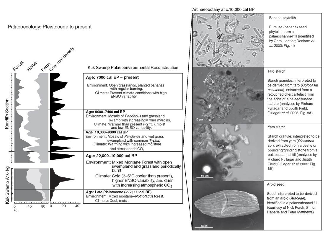
Figure 17.5 Archaeobotanical and palaeoecological information from Kuk: (left) summary pollen and microcharcoal diagram; (right) photomicrographs of phytoliths and starch grain residues from stone tools, and an electron micrograph of an aroid seed at Kuk dating to c. 10,000 years ago.
altitude, or in the highlands generally, during the Pleistocene. Nut production, or masting, in P. brosimos is not seasonally reliable and varies with climate. In weakly seasonal climates, such as the upper Wahgi valley, nut production is also weakly seasonal and discontinuous. Consequently, in this part of the highlands, P. brosimos would not have provided a predictable food source to facilitate seasonal occupation.
Second, the floors of highland valleys are assumed to have been carpeted with resource-depauperate Nothofagus-dominated forests following the downward altitudinal movement of vegetation communities during the LGM. Although true for some inter-montane valleys, pollen diagrams from the upper Wahgi valley are variable. At Kuk (c. 1,560 m), mixed lower montane forests persisted before, during, and after the LGM. In contrast, at the slightly higher altitude site of Draepi-Minjigina within the same valley (c. 1,890 m), mixed oak forests drop markedly and Nothofagus forests predominate. The persistence of lower montane forest on the valley floor at Kuk is significant, because these forests are comparatively rich in faunal and floral resources, especially in comparison to Nothofagus forests that are relatively devoid of edible plant resources other than P. brosimos.[1000]
The re-evaluation above suggests people did not just inhabit the highland interior of New Guinea on a seasonal basis. Such a model only applies to Nothofagus forests in more seasonal climates; it does not apply to the less seasonal parts of the highlands, such as the upper Wahgi valley, which continuously maintained a broader resource base.[1001] In any case, people were mobile and ranged across the highlands and lowlands to access resources throughout the year.
This highly mobile land-use patterning is evident in the Ivane valley where multiple open sites show that groups of foragers exploited high altitude Pandanus and lower altitude yams during the Pleistocene.[1002]Transitions
Various models have proposed how people's plant exploitation practices changed around the Pleistocene-Holocene transition.[1003] In general terms, these models focus upon how people increasingly began to manage the landscape and the edible plant resources contained within it. For example at Kuk, in contrast to other highland locales, early Holocene warming and increased precipitation did not lead to forest encroachment and the replacement of grasslands; rather, rainforest advance was ‘muted' and a mosaic of grassland and forest subject to episodic burning persisted.
Within the upper Wahgi landscape, people focused on areas where edible resources were potentially different and more abundant than under the forest canopy. These included disturbed gaps within the forest, such as landslides and tree falls; the disturbed patches people created; as well as ecotones, riparian corridors, and wetlands. Over time people increasingly maintained these environments and created new ones within the forest using fire and stone tools. The increased human intervention in the landscape was designed to increase resource density and the productivity of favoured species, primarily plants, but also presumably to hunt and gather the fauna attracted to and supported by the increased edible resources within those gaps and patches.
There are two significant transitions that contributed to the change from resource intensification to cultivation. First, people began to focus on, and to increasingly manage, certain types of plant for their diet, which led to deliberate planting. Second, people began to create new environments, or cleared plots, within the forest for planting.
Transition ι: At some point, people began to increasingly focus upon the management of individual species: starch-rich plants such as bananas (Musa spp.), taro (Colocasia esculenta), yams (Dioscorea spp.), and edible grasses, including sugarcanes (Saccharum spp.) and pit-pit (Setaria spp.); oil- and protein-rich palms and trees (Pandanus spp.
and Castanopsis sp., respectively); and leafy vegetables. At this time, their dietary focus presumably shifted from broad spectrum hunting and gathering, or foraging, to more selective exploitation and management of caloric and oil- and protein-rich plants. Through time, people shifted from solely using burning and clearing to increase the density of favoured plants; they began to deliberately remove reproductively viable parts from plants growing in the landscape and to replant them inrainforests: a model for late Pleistocene forest exploitation in New Guinea', D.R. Harris, ‘An evolutionary continuum of people-plant interaction', and D.E. Yen, ‘The domestication of environment', all in D.R. Harris and G.C. Hillman (eds.), Foraging and Farming: The Evolution of Plant Exploitation (London: Unwin Hyman, 1989), 292-304, 11-26, 55-75.
managed gaps and patches. Given the dominance of vegetative propagation in all forms of traditional horticulture in New Guinea, as well as the transplantation of seedlings, suckers, and cuttings in arboriculture, it is presumed that initial planting was based on a pre-existing awareness of the vegetative capacity of plants. Although the focus here is upon edible plants, the rationale for the earliest planting may not have been primarily food; it could as readily have been to establish boundary markers, gather materials or condiments, medicinal or ritual uses, and a host of other purposes.[1004]
Transition 2: At a later time, people began to create and prepare plots within the forest, as well as in other environments, for planting. Initially, it may be envisaged, planting occurred within managed gaps and artificially created patches in order to supplement the density and range of resources - edible or otherwise. With time, people began to clear areas within the rainforest to create plots primarily for planting; thus, any increased resource density as a result of vegetation clearance or disturbance (characteristic of patches) was incidental and secondary to the plant resources obtained from deliberate planting (characteristic of plots).
Plots were probably not clear-felled; large trees were probably left standing after being ring-barked or pollarded to provide shade and to assist soil retention. Minimal tillage can be envisaged, in which planting occurred by dibbling, or making a hole in the ground using a stick, planting, and then filling in by hand.The archaeological, chronological, palaeoecological, and stratigraphic evidence for these two transitions is inevitably ambiguous. How is it possible to differentiate resource intensification from localized, small-scale relocation and planting within the landscape? How is it possible to differentiate patches with limited planting from plots with a greater degree of planting? These ambiguities are conceptual, in the sense that agriculture in New Guinea represents a dependence upon cultivated plants for food and not just food production or planting.[1005] These ambiguities are also methodological, in the sense that the fragmentary and partial evidence could be interpreted in many ways. These issues are illustrated by wetland manipulation and plant exploitation at Kuk c. 10,000 years ago.
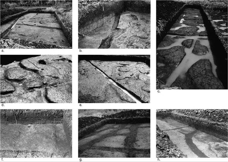
Figure 17.6 Archaeological features indicative of early agricultural practices at Kuk: general (a) and close-up (b) images of the early Holocene palaeosurface dating to c. 10,000 years ago; general (c) and close-up (d-e) images of the preserved bases of mounds and pit with post hole (f) dating to c. 7,000-6,400 years ago; triangular ditch junction (g; crosscutting ditch in the centre of the image) and dendritic ditch junction (h) dating to
c. 3,000-2,500 years ago.
Ambiguities of practice, c. 10,000 years ago
Despite contrary claims, there is insufficient evidence to unambiguously determine that cultivation in prepared plots occurred on the wetland margin at Kuk c. 10,000 years ago.[1006] There are, however, multiple lines of evidence suggestive of people clearing vegetation and exploiting starch-rich plants in a restricted area on the wetland margin at this time (Figure 17.6).
These include:1. Anthropic disturbance of montane forests using fire and presumably stone tools to maintain a mosaic of habitats in the landscape.
2. Localized clearance of vegetation and soil disturbance evident in the fills of an adjacent palaeochannel.
3. Digging, possibly for planting and harvesting.
4. Possible staking of plants.
5. Modification of the palaeosurface to aid drainage within a cleared area.
6. Procurement and processing of starch-rich plants, including possibly taro (Colocasia esculenta) and a yam (Dioscorea sp.).30
To recap, this multidisciplinary evidence is insufficient to unequivocally state that these practices represent agriculture, i.e. cultivation within a plot, as they may as equally represent incidental planting within a maintained patch. Three key lines of evidence are ambiguous and require clarification. First, the extent of soil preparation is unknown, although immature A/C soil profiles are consistent with limited soil formation during short-lived locally drier conditions.[1007] [1008] Given that minimal tillage is likely to have occurred, as it does in many forms of swidden cultivation in New Guinea today, additional evidence for soil preparation need not be present. Second, features and artefacts do not necessarily indicate planting, although they may be consistent with the anticipated range of archaeological remains associated with planting in a patch or plot. These include staking, digging, microtopographi- cal manipulation for surface drainage, and processing of plants. Third, evidence for planting is suggestive, but ultimately equivocal. Although Musa section bananas (formerly Eumusa section), taro, and some yams are generally considered to be of lowland derivation, and are all present at Kuk c. 10,000 years ago, the precise altitudinal range of these plants in New Guinea at that time is uncertain.[1009] Thus, it is not clear whether these plants were brought to the highlands for cultivation or were growing wild in the Kuk vicinity.
Conservatively, the multidisciplinary evidence for practices on the wetland margin at Kuk c. 10,000 years ago is suggestive of intensive use of the landscape and plants, but it does not necessarily reflect a way of life dependent upon the cultivation of food in plots. In terms of the two transitions identified above, there seems to be an emerging focus on starch-rich plants, perhaps growing locally (including taro, a yam, and possibly bananas), and there is evidence for the creation of patches or plots. Ultimately, though, evidence for planting is equivocal.
Swidden cultivation across the landscape
Something different started to occur within the upper Wahgi valley landscape during the early Holocene.[1010] Direct archaeological evidence of these practices is lacking from Kuk, but disturbance of the montane rainforest using fire and stone tools continued, and perhaps increased, on the valley floor to create a mosaic of expanding grasslands and disturbed montane forest, primarily composed of subcanopy taxa (Figure 17.5). Phytolith frequencies and intact phytolith chains indicate bananas were periodically common and are likely to have been planted locally. Additionally, people continued to exploit starch-rich plants, including taro and a yam. Taken together with increased erosion rates within the Kuk catchment, swidden cultivation is inferred to have been developed and practised on the valley floor during the early Holocene.
Cultivation using mounds, 7,000-6,400 years ago
The earliest archaeological remains of former mounds used for cultivation date to c. 7,000-6,400 years ago on the wetland margin at Kuk (Figures 17.6c-f and 17.7 below). Mixed-method sedimentological investigations indicate that these mounds are artificial.[1011] Mounded cultivation coincides with ‘higher levels of burning, dramatic falls in Pandanus and other forest species, and dramatic increases in herbs, predominantly grasses', as well as locally drier conditions.[1012] The more effective clearance of forests is associated with the use of ground stone axe-adzes from this time.[1013] Grasslands maintained by burning persisted until the late twentieth century in this landscape.[1014]
Elevated phytolith frequencies of bananas are interpreted as representing cultivation within mounded plots as well as elsewhere in the landscape.[1015]
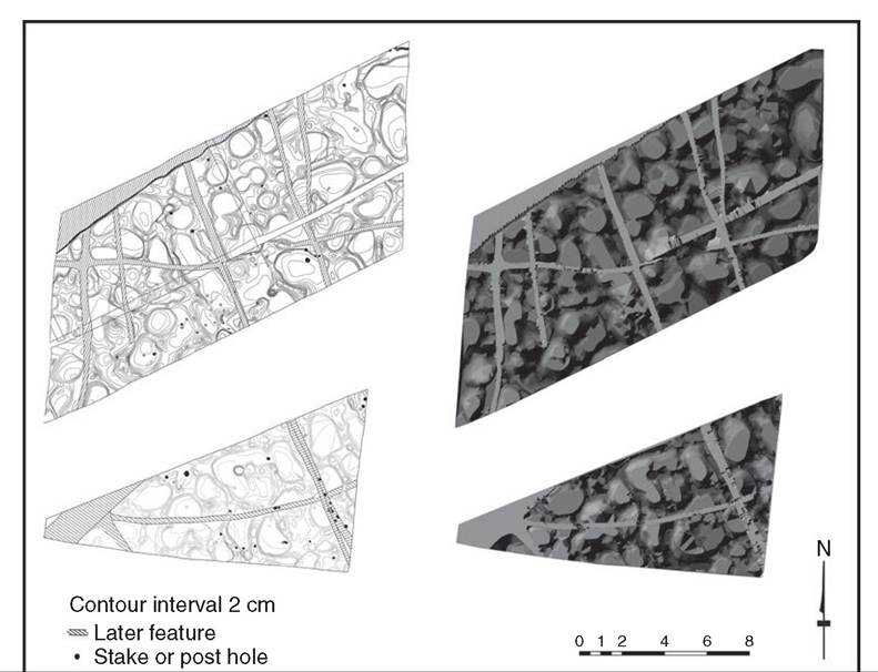
Figure 17.7 Digital representation of the preserved bases of mounds dating to c. 7,0006,400 years ago.
Residues on stone tools recovered from features and soil/sediment associated with the mounds suggest continued exploitation of tuberous plants, including taro.[1016] Consequently, the multidisciplinary evidence demonstrates cultivation of bananas, and presumably other plants, in specially prepared plots containing mounds. People would have been heavily reliant upon these cultivated plots because the surrounding landscape was degraded to anthropic grasslands maintained by burning; in other words, to a landscape with limited edible plant resources.
Golson originally considered the mounds to have enabled the cultivation of plants with different edaphic requirements: water-tolerant plants (such as taro) in the wetter areas between mounds, and water-intolerant plants (such as sugarcane, Saccharum spp.) on the drier raised islands. However, the diatom assemblages in the fills of features between mounds are suggestive of damp conditions rather than standing water. Mounds were probably generalized innovations for cultivation in the colder altitudes of the highlands; namely, they provided slightly warmer growth environments for plants due to cold air drainage over and around the mound, as well as composting within its interior.[1017] The innovation could have been adapted to wetland margins, as Golson envisaged, although it plausibly occurred on dryland slopes across the lower floor of the upper Wahgi valley around the same time, or earlier. Mound cultivation extended into wetlands when local conditions permitted, hence the variable dates for archaeological remains at Kuk, Mugumamp, and Warrawau.[1018] Archaeological evidence of mounds is better preserved in the wetlands, where burial followed the return of wetter conditions and abandonment. On drier slopes any evidence has been destroyed through subsequent gardening, soil formation, and erosion.
The advent of ditches, c. 4,500-4,000 years ago
Around 4,500-4,000 years ago, people began to construct ditches to drain Kuk and other wetlands (Figures 17.6g-h and 17.8). The earliest ditches at Kuk date to at least 4,000 years ago, and a wooden hastate-shaped spade was collected from a ditch at Tambul (2,170 m) and radiocarbon dated to c. 4,600-4,100 years ago.[1019] Most drainage networks documented archaeologi- cally are rectilinear and comprise straight ditches articulating at right angles, although curvilinear forms also occur.[1020] The palaeosurfaces and palaeosols associated with these former field systems, especially the earlier ones, have mostly been reworked during subsequent periods of drainage and cultivation.
b) 585 complex
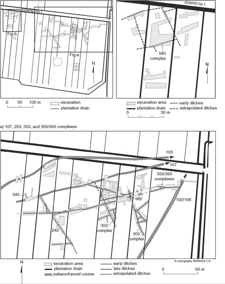
Figure 17.8 Plans of the oldest ditch networks exposed in excavation at Kuk: ‘early' ditches date to c. 4,400-4,000 years ago, and ‘late' ditches date to c. 3,000-2,500 years ago.
Ditches and ditch networks at Kuk have been grouped into a series of phases based on stratigraphic and tephro-chronological correlations;[1021] the fills of only a few features have been radiocarbon dated. Although specific ditches and ditch networks show periods of use, abandonment, and in some cases re-use, a reliable and detailed chronology for drainage and cultivation has not yet been constructed for Kuk as a whole. The wetland was abandoned due to warfare and uncultivated at the time gold prospectors entered the valley in 1933,[1022] and presumably there were periods of abandonment in the past. However, it has proven difficult to disentangle spatially variable use at different temporal scales; namely, to differentiate longer periods of abandonment possibly across the whole wetland from shorter periods of abandonment to fallow within a mosaic of plots that are in various stages of cultivation across the wetland.
Despite these chronological uncertainties, ditches did become more widespread within the highlands from c. 2,750-2,150 years ago, given synchronous occurrence at Kuk, Haeapugua, Kana, and Warrawau then, and subsequently at numerous sites. Around that time, wooden digging sticks and spades, stone artefacts, and archaeobotanical remains become more common. These include remains of wax gourd (Benincasa hispida) at Kana.[1023]
Ongoing elaborations
Evidence for drainage and cultivation at Kuk and other wetlands includes sequential agronomic innovations that continue to the present, such as Casuarina tree-fallowing and the introduction and adoption of the pig (Sus scrofa) and sweet potato (Ipomoea batatas). Although some innovations have had only minor impacts, others have transformed agriculture as well as highland societies.
The planting of Casuarina in fallow land fixes nitrogen and increases carbon in the soil, thereby enriching it for subsequent cultivation.[1024] Seedlings of Casuarina oligodon are transplanted into plots near the end of the cropping cycle and left to grow for eight to twelve years before being felled, ring-barked, or pollarded for firewood and timber. Archaeobotanical evidence suggests Casuarina tree-fallowing was practised at Kuk within the last i,ooo years,[1025] with palaeoecological evidence suggestive of slightly earlier development elsewhere in the highlands.[1026] Today, Casuarina tree-fallowing is still only practised in a restricted geographic area of the highlands.
Pigs are an Asian domesticate thought to have been introduced to New Guinea within the last 3,500 years; they were uncommon in the highlands until the last 1,500 years.[1027] Sweet potato is a South American domesticate introduced to the Pacific by Polynesians, although generally considered a post-Magellan introduction to New Guinea.[1028] In the early twentieth century highland societies were heavily reliant on sweet potato cultivation for carbohydrate, although they were only variably dependent upon pig rearing for protein. Sweet potato is considered to have greatly increased the productivity of highland agricultural systems previously based on taro, bananas, and some yams. Pig rearing could feasibly have alleviated protein deficiency in many highland societies, although pigs were primarily used as valuables in exchange networks and for feasting rather than for regular daily consumption. Ethnographically observed ‘big-men’ societies in the highlands are thought to postdate the introduction and widespread adoption of intensive sweet potato cultivation and pig rearing.