China's vast landmass ranges across contrasting ecological extremes, from tropical in the south, to sub-Arcticin the north, and alpine in the west (Map i2.ι).
Seventy per cent of this landmass is composed of mountains, plateaux, and hills, and over a substantial part of the country, particularly the continental interior, the availability of water is critical.
These features have led to an agriculture that is diverse in its crop ecology, elaborate in its management of water, and at its most intense in the lowlands in the east of the country.In the west, the cloud capture and montane glaciers provide a critical source of water, feeding China's two longest rivers, the Yangtze and the Yellow River. The Yangtze runs approximately 6,500 km to the sea at Shanghai, through hilly regions into swampy lowlands, along its course draining a fifth of China's land surface. The Yellow River runs approximately 5,500 km through the loess plateau towards the Bohai Sea. The lower reaches of those two rivers frame the northern and southern borders of China's most productive stretch of lowland, the Central Plain, the arena within which much of the history of Chinese civilization has played out. These two rivers have an enduring association with important staple cereals: the Yangtze with rice, and the Yellow River with the Asian millets (broomcorn and foxtail).
Their catchments also include the loci of the domestication of these cereals, but at some remove from lower reaches and plains in which their cultivation subsequently became the most intense. The earliest archaeological sites for the millets are in the middle reaches of the Yellow River in the loess plateau, and also along the foothills that arise at some considerable distance from the river itself. Long before the water in the valley bottom could be effectively managed, the capture of run-off in foothills and elevated locations was critical to the emergence of northern agriculture. The earliest sites for rice are in the middle and lower Yangtze as well as in the Huai River just to the north.
These early rice locales are associated with docile minor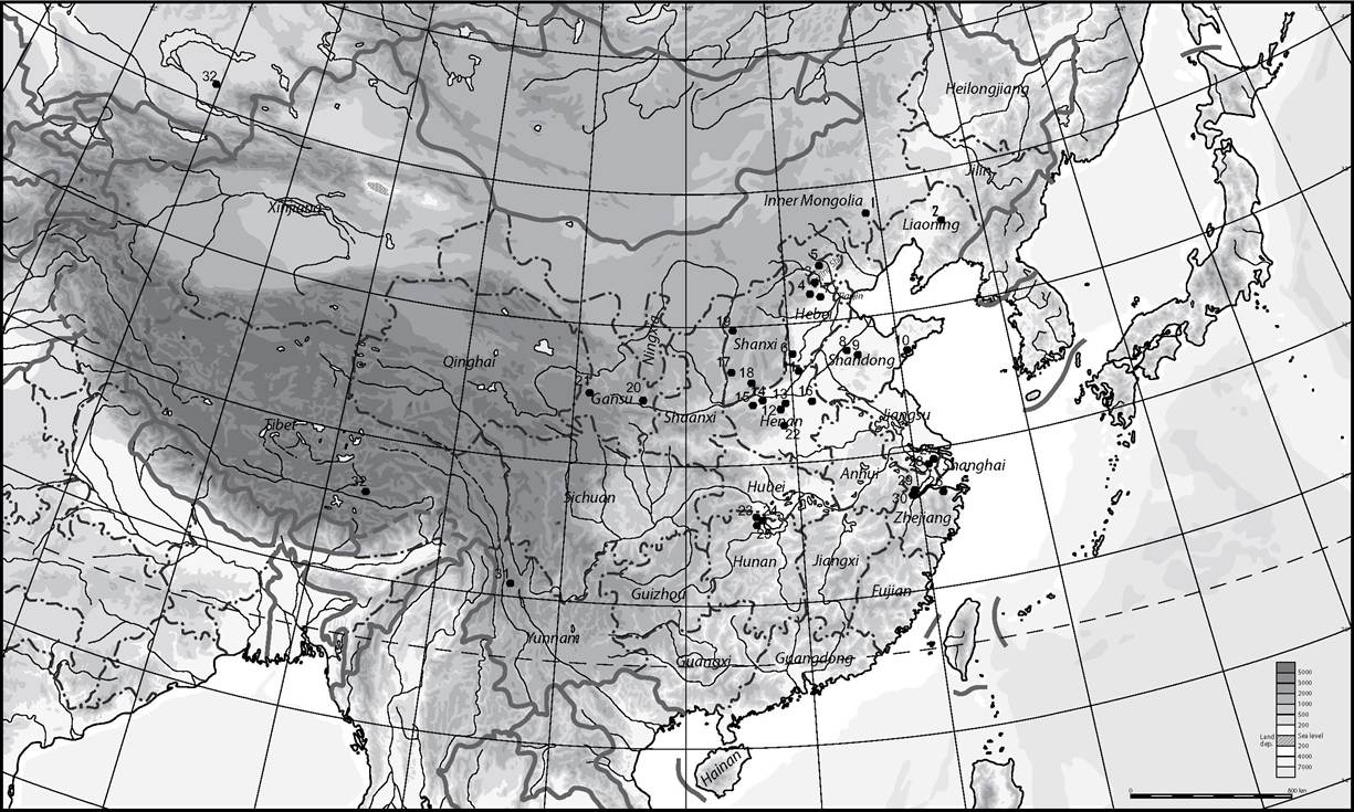
Map i2.i China showing principal regions and sites mentioned in the text. Key for the map: 1. Xinglonggou; 2. Xinle; 3. Zhoukoudian;
4. Nanzhuangtou; 5. Donghulin; 6. Cishan; 7. Taixi; 8. Yuezhuang; 9. Daxinzhuang; 10. Zhaojiazhuang; 11. Anyang; 12. Peiligang; 13. Shawoli;
14. Wuluoxipo; 15. Erlitou; 16. Xishuipo; 17. Shizitan; 18. Xiachuan; 19. Liulin; 20. Dadiwan; 21. Linjia; 22. Jiahu; 23. Pengtoushan; 24. Chengtoushan;
25. Bashidang; 26. Hemudu; 27. Chudun; 28. Caoxieshan; 29. Mojiashan; 30. Maoshan; 31. Haimenkou; 32. Changguogou; 33. Begash.
tributaries and the wetlands of distal floodplains where cultivation could be more easily managed. By the second millennium bce, the agrarian management had extended downstream, and the high energy of the main rivers was moderated by irrigation management of increasing scale and complexity. This practice emerges in the documentary record of the first millennium bce in the form of substantial hydraulic projects associated with named engineers, such as Sunshu Ao (sixth century), Ximen Bao (fifth century), and Li Bing (third century).1
To the north of this principal arena of Chinese agriculture, the Central Plain is flanked by the Gobi desert, and beyond that a belt of steppe that continues westwards across Eurasia. Ecologically, both regions are constrained by water scarcity and the severity and length of the winter season. They have nonetheless been of considerable cultural and agricultural significance. For several episodes of China's past, the northern communities have held political sway over the south, and their mobility has facilitated the appearance in China of a range of animals of importance to agriculture, such as the horse and camel, and probably also sheep, goats, and taurine cattle. These mobile peoples around the northern and western fringes of China also facilitated the transfer of crops into and out of China.
The ten millennia of the Holocene in which agriculture has expanded is also a time in which the environment has undergone some change. A key dynamic element is the monsoonal system, comprising a warm, wet summer monsoon, and a cold, dry winter monsoon. The summer monsoon brings water from the Indian and Pacific Oceans onto much of the south and east of China and has a powerful ameliorative effect on the intrinsic aridity of the continental interior. The winter monsoon drives the movement of aeolian dust from the Gobi desert to the loess plateau. The sensitivity of that monsoonal system to fluctuations in the relative temperatures of land and ocean has rendered it the most variable part of the physical environment, critically affecting the water availability in many parts of China, particularly towards the south and east. In western China, the westerlies are the stronger determinants of water availability. A widespread consequence of these combined factors is a drier earlier Holocene and a wetter mid-Holocene, followed by a return to aridity. The timing of the moister mid-Holocene varies according to location in China, particularly in relation to the monsoons. In the loess plateau, for example, it runs from c. 8,500 bp to c. 5,000 bp, in other [631] words following the earliest episodes of cultivation but facilitating the spread and establishment of domestication, while predating the episode of food globalization discussed below.