Mainland Southeast Asia (MSEA) and island Southeast Asia (ISEA) form a complex geographic and political region consisting of eleven countries spread from India to China and New Guinea (Map 16.1).
MSEA consists of Cambodia, Laos, Malaysia, Myanmar, Thailand, and Vietnam. The islands (ISEA) include the nations of Indonesia and the Philippines, Singapore, the Sultanate of Brunei, and East Timor.
The island of Borneo, as well as being home to Brunei, also consists of the Federated States of Sarawak and Sahul and the Indonesian region of Kalimantan. Other large islands include Sumatra, Java, Sulawesi, Flores, Timor, Halmahera, and Seram. Island chains reach from the Philippines to Borneo via Palawan and also to the south through the Sulu archipelago. The Lesser Sunda Islands form a scattering of small islands along the ‘ridge of fire' from the east coast ofJava to Timor, providing an island-hopping route from Sumatra to the Moluccas, west of New Guinea.The climate of this region ranges from humid subtropical to tropical from southern China into Vietnam, with lowland and montane evergreen forests, deciduous dipterocarp forests, limestone karst forests, littoral forests, and peatswamp and mangrove forests. These forest types are typical of much of the region, with deciduous dipterocarp forest replaced by evergreen mixed dipterocarp forests closer to the equator. Climates are affected to a greater or lesser extent by the intertropical convergence zone, creating strong seasonal changes in rainfall and cyclonic weather, especially along coastal regions.
Thailand is under the influence of the monsoon winds, having a northeast and southwest monsoon season with high periods of rainfall along the coasts, but areas of relatively dry climate in the interior on the leeward side of the mountains. Borneo is generally wet throughout the year with annual rainfall of over 3,000 mm along the northwest coast, but with more seasonal climes along the eastern coast of Kalimantan. The Lesser Sunda Islands have the driest climates in Indonesia, supporting a distinct biota on the other side of
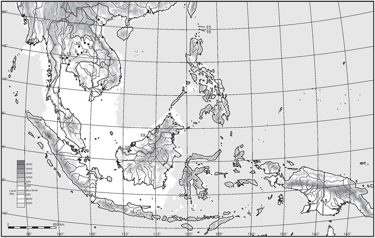
Map 16.1 Southeast Asia, showing the principal archaelogical sites mentioned in Chapter 16: ι.
Xincun; 2. Spirit Cave; 3. DaBut; 4. Phung Nguyen; 5. Tach Lac; 6. Rach Nui; 7. An Son 7. Loc Giang; 8. Kok Phanam Di; 9. Neon U-Loke; 9. Ban Lum Khao; 10. Non Nok Tha; ιι. Ban Chiang; 12. Ban Na Di; 13. Nil Kham Maeng; 13. Nor Mak La; 13. Non Pa Wai; 14. Ban Non Wat; 15. Anaro; 16. Sunget; 16. Savidug; 17. Andarayan; 18. Gua Sireh; 19. Niah Cave; 20. Leang Burung; 20. Ulu Leang.Webber's Line with deciduous forest, patches of dry thorny forest, and areas of savanna grassland.
The landforms of MSEA incorporate coastal, often swampy plains and interior flood-prone valleys, dissected by intervening uplands. The interiors of Thailand and Cambodia consist of large areas of lowland plains with the Khorat plateau to the north of Thailand and the Chao Phraya plains in the southwest. Several of the large islands such as Sumatra and Borneo support high interior ranges rising up from low, swampy coastal plains of lowland peat swamp and lowland dipterocarp rainforest. Several major rivers may have formed important routes from coastal regions inland and vice versa in prehistory, enabling rapid movements of population. By the colonial period, many of these big rivers, and their multitude of smaller branches, formed an arterial network of major trade routes carrying imported ceramics, bronze, scented woods, rattan, bird nests, and a multitude of other goods.