Australasia and the Pacific
IAN J. MCNIVEN
There is a point on Google Earth where you can rotate the image of the globe so that all you see is the vastness of the Pacific Ocean and the continental landmasses of Australasia (Australia and New Guinea).
Taking in 190 million km2 and more than a third of the globe, the world of Oceania, embracing Australasia and the Pacific, has a diverse human history spanning at least 50,000 years and including the speakers of nearly 1,300 historically known languages. This history is one of extremes, with small groups of modern humans (Homo sapiens) migrating out of South-East Asia and voyaging across the seas to the Ice Age mega-island of Sahul (Australia and New Guinea) by 50,000 years ago. This migration left behind a history that began 1-2 million years ago and involved three species of human: Homo erectus, Homo floresiensis (the ‘hobbit') and modern humans. For nearly all of this time, the vast expanse of Remote Oceania - extending for 12,600 kilometres east-west between Palau and Rapa Nui (Easter Island) and for 8,100 kilometres north-south between Hawaii and New Zealand - was empty of people. It is not until 3,500 years ago that pioneering seafarers began venturing eastwards from the islands of northeastern New Guinea and across other Melanesian islands of Near Oceania and eventually into Remote Oceania (taking in the islands of southern and eastern Melanesia, Polynesia and Micronesia). Polynesian seafarers finally reached New Zealand (Aotearoa) in the south 700 years ago. Here in the Southern Ocean the ancestors of the Maori, in perhaps the final great act of human global colonisation, landed a mere 1,400 kilometres from Tasmania where Ice Age colonists settled 40,000 years earlier. The abysses of time separating the colonisation histories of South-East Asia, Australasia and the Pacific are reflected in the diverse array of societies that moved into and emerged inHelpful comments on an earlier version of this chapter were kindly provided by Jeremy Ash, Geoff Clark, Joe Crouch, Ian Lilley, Lynette Russell and Glenn Summerhayes.
Thanks to Michael Morrison and Glenn Summerhayes for assistance with images. each of these immense geographic and cultural domains. These societies developed different forms of organisational structures ranging from the largely achieved leadership of hunter-gatherer Aboriginal Australia and ‘Big Man' societies of agricultural New Guinea through to the hereditary chief- doms of agricultural Polynesia.1 Yet despite the vast distances separating these communities, the past 3,000 years is a history of connections between groups located hundreds and in some cases thousands of kilometres apart. Such connections represent key themes in the social and political histories of these regions, with complex alliance and ceremonial exchange systems expressing myriad intergroup cultural dynamics, adaptive strategies and the entrepreneurial desires of peoples to mutually construct their social worlds through inter-community networks.Charting the expanse of Oceanic history is a daunting task given what we know and do not know. This chapter embraces the challenge of presenting a summary history of Oceania, focusing on chronological changes in social interactions and social formations over the past 3,000 years using selected case studies to illustrate the flavour of Australasian and Pacific island societies. I have divided this history into Australia, Melanesia, Polynesia and Micronesia while being acutely aware that such divisions are colonial constructs that have in many respects outlived their classificatory and heuristic usefulness.[788] [789] A key feature will be a consideration of the blurred and dynamic boundaries and cultural and historical overlaps between divisions, particularly the Melanesia-Polynesia divide. A further limitation of these divisions is that they privilege European scholarly traditions at the expense of Indigenous people's epistemologies and historical constructions of their pasts. For these societies, the symbolic process of recording information and knowledge was not formal writing but elaborate oral histories and complex forms of material culture.
Written historical records for Oceania began with the arrival of Europeans in the sixteenth and seventeenth centuries. Modern Western historiography, in an attempt to transcend the limitations of its own disciplinary confines, is attempting to write more inclusive histories of Oceanic peoples through collaborative research which allows nuanced and culturally informed readings of ancient material culture using archaeological techniques enhanced by oral histories and recent ethnographies.[790] This approach is slowly shining a light on the previously hidden histories of Oceania and placing these within the broader narratives of humanity's shared and connected pasts.Australia
At the time of sustained British colonial invasion in the late eighteenth and nineteenth centuries, Australia was home to upwards of ι million Aboriginal people divided into at least 250 languages and hundreds of ‘tribal' groupings. In addition, the mainlands of Australia and New Guinea were separated by the 150 kilometre-wide Torres Strait, the maritime home of some 3,000-4,000 people divided into at least fifteen island communities and two major language groups. Owing to the complex and dynamic nature of Aboriginal social organisation which operated at a variety of scales, each with its own negotiated territorial boundaries, the term ‘tribe' is seen by anthropologists today to be simplistic and of limited descriptive value. While the subsistence regime of Aboriginal peoples has traditionally been characterised as hunting and gathering, it is becoming increasingly clear that most groups also practised degrees of food production, resource intensification and environmental manipulation.[791] For example, all groups fired the landscape to change vegetation and promote growth of certain plant and animal species. More extreme, the Gunditjmara of south-west Victoria radically manipulated waterways and swamps to enhance growing conditions for eels as a form of aquaculture.
Even in the Torres Strait located next to agricultural New Guinea, food production systems on islands ranged from large-scale agricultural mound-and-ditch field systems to subtle enhancement of hunting-and-gathering landscapes through fire. In all cases, groups practised degrees of mobility between strategically spaced and placed settlements across mosaic landscapes to accommodate natural and culturally constructed spatial and seasonal variations in resource availability. Social and political organisation also varied considerably across the continent, with leadership amongst clan and multi-clan groups ranging from earned through to rare cases of hereditary status. Broadly speaking, governance was not institutionalised. Leadership centred on a group of senior male Elders who had acquired through experience critical social, political and religious (secular and sacred) knowledge. Beyond local clan affairs, governance and leadership also concerned maintaining and controlling complex sociopolitical and ceremonial relationships and exchange networks with neighbouring groups. An important feature of exchange transactions in Aboriginal societies is that they helped maintain social relationships between peoples and communities. In this sense, chronological and spatial changes in the movement of goods also maps out the changing history of social, political and religious networks and relationships.[792]Archaeological research reveals that the foundations of Aboriginal societies and cultures were laid down in the deep past during the Pleistocene (Ice Age) between 10,000 and 50,000 years ago. It is generally believed that Australia was colonised by maritime peoples originating in South-East Asia at least 50,000 years ago using watercraft when sea levels were more than 50 metres lower than present and the Australian mainland was joined to Tasmania in the south and New Guinea in the north to form the mega-island continent known as Sahul.[793] All major environments across Sahul had resident communities by 40,000-45,000 years ago, demonstrating the extraordinary adaptability of these ancient peoples.
While population numbers during the Pleistocene were low and many areas were used only marginally compared to the situation recorded historically, long-distance movement of objects reveals large-scale social networks and information flow spanning hundreds of kilometres across the continent. For example, at Lake Mungo in western New South Wales, the nearest known source for red ochre associated with a burial dated to 40,000-45,000 years ago is at least 200 kilometres away. Around 30,000 years ago the presence of marine shells in the lower levels of Riwi rockshelter in northern Western Australia indicates movement of symbolically charged objects over a distance of at least 500 kilometres from their coastal source.[794] Off the north-east coast of Sahul on New Ireland (Papua New Guinea), obsidian artefacts found in the lower levels ofMatenbek rockshelter dated 18,000-20,000 years ago derive from quarries located 350 kilometres distant on New Britain.[795]
Despite ancient foundations, the complex dimensions of social arrangements that characterise ethnographically known Australian Indigenous societies emerged largely within the past 3,000-4,000 years. These dimensions include the development and spread of formalised and distinctive stone-tool types across the continent, regionalisation of rock-art styles, development of large-scale ceremonial gatherings involving hundreds of people, establishment of large-scale prestige object exchange systems and emergence of elaborate ceremonial site complexes. Tula scrapers exemplify the spread of newly developed stone-tool types across much of Australia over the past 4,000 years. They are a special type of scraper made by men retouching a flake such that it has a straight or curved working edge. These were hafted with spinifex grass resin onto wooden handles and even onto the end of spear-throwers. Their robust form makes them well suited to working hard arid-zone woods and highly reliable.
As tulas can be repeatedly resharpened by the removal of tiny flakes from the working edge, they are easily maintained, creating a reliable tool with a long use-life. Such tools are a sophisticated adaptation to the highly mobile lifestyles that characterise arid-zone societies. The shared use of tulas across the arid zone would have facilitated social relationships and networks crucial to negotiating resource sharing amongst highly mobile and territorial groups exploiting harsh arid environments. Use of tulas is seen as part of an array of strategic technological and social developments aimed at establishing and maintaining ‘safety nets' to offset risks associated with environmental uncertainty and resource unpredictability stemming from late Holocene climatic variability, in particular intensification of El Nino Southern Oscillation (ENSO) climatic events.[796] The uptake of distinctive tool types such as tulas reveals a desire for social inclusiveness by multiple neighbouring communities through shared possession and use of mutually recognisable items of material culture. The success of Aboriginal desert societies also centred on shared knowledge and gender relations associated with preparation of grass seed bread following laborious preparation of seed flour by women using large sandstone grindstones. Ethnographically, these large grindstones were prized heirlooms obtained originally through long-distance exchange relationships. Most archaeological evidence for grindstone use in the arid zone dates to the past 3,000 years.[797] [798]Paralleling the spread of tools such as tulas across the continent is the development of formalised exchange networks spanning hundreds and even thousands of kilometres.11 The elaboration of exchange networks involving prestige and symbolically charged objects such as marine shells, Kimberley points and ground-edge axes at various times during the past 3,000 years is seen as expressing and maintaining newly developed social relationships and alliances and an intensification of inter-regional group social, political, ceremonial and religious dynamics. The scale of these networks is revealed by the southern movement of baler shell (Melo sp.) and pearl shell (Pinctada sp.) adornments sourced to the tropical coast of northern Australia across much of the continent over the past 2,000 years.1[799] Indeed, such shells were exchanged, traded or moved across the continent from the northern to the southern shores along pathways spanning some 2,000 kilometres. Such is the complexity of exchanges that in the Port Keats region of the Northern Territory, one set of exchange objects formally passed through the hands of 134 individuals over a distance of less than 300 kilometres in 1950.[800] In many cases, exchange relationships mirrored and celebrated the geographical pathways (songlines) of creator and ancestral beings whose stories were enshrined in Dreaming (cosmological) narratives that imbued landscapes with spiritual essences, power and chains of religious, ceremonial and social connection.[801]
In the Kimberley region of northern Western Australia, delicately made bifacial points with fine pressure-flaking along the margins to create serrated edges were hafted as spearpoints and butchering knives but also used unhafted as knives in ritual and secular contexts.15 Kimberley points made for exchange were prestige objects usually manufactured out of high-quality stone (e.g. jasper or agate, and glass after European contact) and made thin and fragile to enhance aesthetic and other symbolic properties. Exchange networks operated regionally across the Kimberley but also extended over 1,000 kilometres south-east into the desert societies of central Australia where the points could be used as ceremonial knives. Pathways of exchange were complex and worked outwards through intricate kinship networks linked to reaffirming social, political, ceremonial and religious practices, obligations, rights and responsibilities.
In eastern Australia, extensive ground-edge stone-axe exchange networks also reveal chains of connection between hundreds of communities across vast regions. Although the world's oldest-known ground-edge stone axes dating to 35,000 years ago have been found in Arnhem Land, elaborate axe trade networks appear to develop mostly within the past 3,000 years.16 For example, the Lake Moondarra metabasalt axe quarry near Mt Isa in northwest Queensland extends over an area of 2.4 km2. It features raw material extraction pits where up to 30 m3 of rock rubble was removed and manufacturing zones with metre-high piles of flaking debris where blocks of stone weighing up to 100 kilograms were broken apart and shaped into axe blanks ready for export.17 As many as 800,000 partly made axes remain at the quarry site, indicating the scale of production over the past 1,000 years. The local Kalkadoon people took the axes to markets located immediately outside of their territory where exchange took place with their neighbours. From here the axes were traded southwards down western Queensland and
Structure and the Ceremonial Exchange Cycle in Arnhem Land (Melbourne: Macmillan & Co., 1949).
15 Kim Akerman, Richard Fullagar and Annelou van Gijn, ‘Weapons and Wunan: Production, Function and Exchange of Kimberley Points', Australian Aboriginal Studies 1 (2002): 13-42; and Rodney Harrison, ‘AnArtefact of Colonial Desire? Kimberley Points and the Technologies of Enchantment', Current Anthropology 47 (2006): 63-88.
16 Jean-Michel Geneste, Bruno David, Hugues Plisson, Jean-Jacques Delannoy and Fiona Petchey, ‘The Origins of Ground-Edge Axes: New Findings from Nawarla Gabarnmang, Arnhem Land (Australia) and Global Implications for the Evolution of Fully Modern Humans', Cambridge Archaeological Journal 22 (2012): 1-17.
17 Peter Hiscock, ‘Standardised Axe Manufacture at Mount Isa', in Ingrid Macfarlane, Mary-Jane Mountain, and Robert Paton (eds.), Many Exchanges: Archaeology, History, Community and the Work of Isabel McBryde (Canberra: Aboriginal History Inc., 2005). as far as South Australia over a distance of 1,000 kilometres.[802] In south-east Australia, stone axes manufactured by Kulin peoples for at least the past 1,000 years from greenstone quarried at Mt William, north of Melbourne, were traded up to 600-700 kilometres distant.[803] Significantly, some areas that imported the renowned and prestigious axes also had similar stone outcrops suitable for quarrying and axe manufacture within their own territories, revealing that resource scarcity was not a key driver of axe exchange. That movement of Mt William stone axes was largely an expression of social networks, and maintenance of social relationships is revealed by the absence of axe exchange to the east with Gunai/Kurnai peoples with whom the Kulin had hostile relations.
The intensification of social networks and exchange systems during the past 3,000 years can be seen as a strategic move by community leaders to obviate in part social and political frictions associated with population increase and the concomitant emergence of more social groups.[804] Further expressions of these developments were a diversification and regionalisation of rock-art styles, mound-building, elaboration of cemeteries and expansion of inter-regional group gatherings associated with super-abundances of special food resources. Although rock art in Australia extends well back into the Pleistocene, the past 3,000 years saw an efflorescence of stylistic diversity linked to regional developments in corporate group identity and territorial and ceremonial/religious place-marking and place-making strategies to help demarcate social differences and similarities at differing geographical scales.[805] For example, some of Australia's most distinctive rock-art stylistic provinces, such as the Quinkans of the Laura region of southern Cape York Peninsula, the stencilled art of the central Queensland highlands and the Wandjina art of the Kimberley region, all emerge within the past
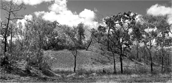
Figure 22.1 Shell mound at Imbuorr, Weipa area, dating to the past 3,000 years (Photograph by Michael Morrison)
2,000-3,000 years.[806] In some regions, particularly along the Murray River in south-eastern Australia, increasing territoriality was expressed in mortuary practices whereby the dead were placed into formalised cemeteries containing hundreds of ancestors.[807] For other communities, place-marking took the form of monumentalising the landscape in the form of mound creation. The most extreme example of this practice occurred along the west coast of Cape York Peninsula, where shells representing the remains of millions of meals were piled up into huge mounds up to 13 metres in height and 2,700 years in age. In western Victoria, a tradition of earthen mound construction commenced around 2,500 years ago whereby campsite deposits, particularly from earth ovens, were heaped up into ι- to 2-metre-high mounds.[808] In some cases the dead were buried within these mounds, and, like formal cemeteries along the Murray River, they expressed and reaffirmed the ongoing complex symbolic link between the ancestors, the living and the land (see Fig. 22.1).
Ethnographic information reveals that many Aboriginal groups participated in large-scale gatherings and feasting involving hundreds of people for social, political and religious reasons and the performance of ceremonies associated with initiation, gift exchange, marriage, etc.[809] Archaeological evidence for the emergence of these gatherings is little understood and often linked indirectly to what is assumed to be concomitant evidence for increases in population during the past 3,000 years. For example, across many parts of the arid zone at various times of the year, hundreds of people from numerous communities would assemble to perform ceremonies sustained by large accumulations of grass seed bread. On the fertile east coast every three years or so, hundreds of Aboriginal people representing numerous groups from north-east New South Wales and south-east Queensland would converge on the Bunya Mountains and Blackall Range in south Queensland to participate in the Bunya festivals. These gatherings were scheduled to coincide with bumper-crops of Bunya Pine seeds.[810] Similarly, during summer months in the south-eastern Australian Alps, after snow had melted and large areas became habitable, hundreds of Aboriginal peoples from groups in far eastern Victoria and south-eastern New South Wales walked hundreds of kilometres to ascend these uplands for gatherings supported by huge congregations of highly nutritious Bogong moths.[811] Each summer, millions of these moths migrate over hundreds of kilometres into the Alps to aestivate, which is a type of hibernation to avoid the searing summer heat. These large colonies of up to 17,000 m2 rest in cool, dry and dark crevices between granite boulders from October to March each year.
In western Victoria, up to 1,000 people from numerous groups were known to gather near Lake Bolac to take advantage of huge seasonal runs of eels. Early historical records from the 1840s record that Aboriginal men constructed large and elaborate stone-walled traps across waterways to catch eels in long baskets woven by women. These records also reveal that Aboriginal people expanded the habitat of eels by excavating extensive networks of trenches across swampy terrain. One such engineering feature was a channel excavated over a distance of 3 kilometres to allow eels to artificially expand their range into a previously uninhabited lake. In this sense, Aboriginal people attended large-scale social gatherings that were supported
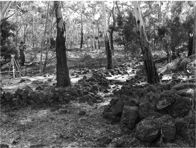
Figure 22.2 Gunditjmara fishtrap at Lake Condah used and modified over the past 6,600 years (Photograph by Ian J. McNiven)
by both natural and artificially constructed super-abundances of eels.[812] At Lake Condah, in the same region, palaeoenvironmental evidence suggests that Aboriginal people dammed off the lake's outlet to artificially maintain water levels and eel stocks around 4,600 years ago to help avert the negative impacts of climatic drying. Excavations at a large 350 metre-long stone-walled fishtrap at Lake Condah indicate even earlier hydrological manipulation with initial channel construction around 6,600 years ago with major stone-rubble wall additions during the past 800 years (Fig. 22.2).[813] Such large-scale hydrological engineering facilities required new levels of social organisation and complexity, and it is significant that western Victoria appears to have had hereditary leaders akin to chiefs.[814]
The past 1,000 years also witnessed rapid demographic, social, political and ceremonial developments across the islands of Torres Strait in the far north-east corner of modern Australia. Increases in the number and size of midden deposits in villages indicate increases in the number of people permanently occupying islands within the past 800 years. Around 400-500 years ago, a number of these communities began building ritual installations in the form of accumulations of large trumpet-shells and huge piles of dugong bones. Some of the shell arrangements contain over 200 shells, while bone mounds range in size from a couple of cubic metres representing fewer than 100 dugongs to the Dabangai Bone Mound on Mabuyag island which contains up to 42 m3 of bone and the remains of 10,000-11,000 dugongs.[815] These shell and bone installations were also incorporated variously into ceremonial site complexes (kod) and were associated with different totemic clan groups. Kod sites were known to host initiation, mortuary and headhunting ceremonies and turtle and dugong hunting rituals. Archaeological excavation of kod sites reveals that these communal ceremonial centres began developing around 400 years ago as a way of both expressing and managing the ethnographically known totemic clan structure of island communities (Fig. 22.3).[816]
Melanesia
The Melanesian world extends from the continental island of New Guinea and south and eastwards out into the western Pacific Ocean through the island nation-states of Solomon Islands, Vanuatu, New Caledonia and Fiji. It includes north-eastern Sahul and Near Oceania and crosses into the central western sections of Remote Oceania. The region is home to diverse cultures and speakers of over 1,000 languages (representing around 20 per cent of the world's languages), of which 900 are found across New Guinea.
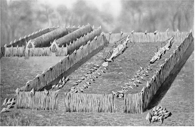
Figure 22.3 Two reconstructed views of the ceremonial totemic site (kod) with hammerhead shark and crocodile effigies, Iama island, Torres Strait, late nineteenth century. Left: with enclosures. Right: without enclosures. (Drawing by A. C. Haddon, from Hutchinson 1931)
The earliest archaeological evidence for people in Melanesia comes from sites in the Ivane Valley in the Highlands of Papua New Guinea (PNG) located 70 kilometres inland from the modern city of Port Moresby on the south coast. Here radiocarbon dates of up to 49,000 years ago have been obtained on charcoal found associated with a range of stone tools.[817] Remarkably well-preserved yam starch grains and carbonised pandanus nutshells provide rare insights into Ice Age plant food use in this remote montane valley elevated ~2000 metres above sea level. Excavations at Matenkupkum limestone rockshelter on New Ireland indicate that terminal Pleistocene peoples of New Guinea were also exploiting marine resources such as shellfish and fish. The hunting-and-gathering Ice Age societies of New Guinea most likely lived in small clan-based communities who moved seasonally across landscapes and between resource patches which they understood intimately. Little is known of the ceremonial, religious, social and political life of these ancient peoples.
Around 10,000 years ago, Highland communities of PNG began planting yams, bananas and taro in swidden patches, supplemented by considerable foraging for wild plants and hunting of animals in local forests. By 7,000 years ago, cultivation intensified, evidenced by the construction of elaborate artificially constructed mounds and drainage channels and related environmental evidence for major forest clearance and burning associated with swidden cultivation and consequent development of grasslands.[818] It is likely that such large-scale water management systems were accompanied by changes in social organisation whereby new hierarchies of leadership developed to accommodate the demands of agricultural production and long-term commitments and investments in tending to crops and maintaining channels. Key agricultural crops recorded ethnographically are taro, bananas, yams, sugar cane and sweet potato. In many lowland regions, sago palm was the major cultivated starch staple.
One of the attributes of plant food production is that it helps support more sedentary populations with higher population densities and increased territoriality. By 4,000 years ago evidence for intensified use of the Highland valleys exists in the form of a move away from rockshelter encampments to permanently occupied villages supported by agriculture with concomitant increases in territoriality.[819] The pace of social change picked up in the past couple of thousand years with the introduction of the pig and again around 500 years ago with the introduction of South American sweet potato, which was grown in surplus as fodder to support large herds of domesticated pigs that were husbanded as prestige items for ceremonial exchanges and associated feasting.[820] Such competitive ceremonial practices were central to the development of ethnographically known intense and elaborate social interactions between highly territorial and warring tribal groups in the Highlands and the development of Big Man societies. At the time of first contact with the outside world in the 1930s, the Highlands region of New Guinea was home to around 1 million people with population densities of up to 300 people per square kilometre. A broad array of prestige wealth-goods was also involved in competitive ceremonial exchange networks involving Highland valley communities, centring on shell valuables (traded up from the cost), large stone axes, bird-of-paradise feathers, salt, etc. Stone-axe production in the Western Highlands has been documented at ethnographically known quarries dating back to ι,000-2,500 years ago. Axes from these quarries, produced at rates of up to 1,000 per year by 200 men working full-time for four months in shafts up to 15 metres deep, entered into local ceremonial exchange networks as prestigious items (e.g. bride price) and also moved up to 350 kilometres away along trade routes down into lowland regions.[821]
On the coastal lowlands of north-east Papua New Guinea, systems of exchange began intensifying considerably with the emergence of Lapita maritime peoples around 3,500 years ago. Lapita peoples are identified archaeologically by the presence of earthenware pottery decorated with finely executed, dentate-stamped designs and motifs. The development of what has become known as the Lapita Cultural Complex occurred across islands of the Bismarck Archipelago of north-east PNG and is linked to the movement and accommodation of Austronesian-speaking people into the region from island South-East Asia. Lapita maritime peoples then moved out to the previously uninhabited islands of Remote Oceania, appearing around 3,200 years ago in the eastern Solomon Islands before moving on to Vanuatu, New Caledonia and Fiji around 3,000 years ago, and out into Western Polynesia and the central Pacific nations of Tonga around 2,900 years ago and Samoa around 2,700 years ago. By 2,900 years ago, Lapita peoples had also migrated southwards to the southern mainland coast of PNG where they negotiated settlement amongst existing resident peoples. While Lapita pottery continued through to c. 2,200 years ago in Near Oceania, in Remote Oceania Lapita pottery lasted only for 200-300 years. Apart from distinctive pottery, characteristic features of the Lapita Cultural Complex included use of obsidian for flaked tools, and the manufacture of clam shell adzes, shell fishhooks and cone shell arm rings. Subsistence practices focused on agriculture and the use of marine resources (e.g. fish, sharks, turtles, shellfish) from coastal settlements, including stilt villages and hamlets over reef platforms. Lapita peoples most likely introduced to Oceania the pig, dog, chicken, Pacific rat, at least fifteen plant species
(including cultivated taro, yams and bananas) and probably outrigger sailing
38
canoes.
Similarity in the Lapita Cultural Complex across some 4,500 kilometres of the western Pacific reveals considerable information flow and networking between numerous communities. In many respects, these networks had antecedents in the ancient exchange networks of the Bismarck Archipelago, where movement of obsidian and live animals over hundreds of kilometres between islands extends back into the Pleistocene and more than 20,000 years ago. In addition, between 8,000 and 3,000 years ago, stone mortars and pestles of probable ritual significance were used across a large area of New Guinea over a distance spanning at least 1,000 kilometres. Such shared stylistic practices point to large-scale social networks and cultural interaction spheres.[822] [823] These exchange networks were transformed, elaborated and expanded during Lapita times and were critical to the success of colonising populations in terms of establishing viable communities on newly discovered islands. For example, obsidian found in multiple layers of Lapita sites in the Reef/Santa Cruz islands (Solomon Islands) shows continuing (albeit indirect) connections with quarry sources and ‘homeland' communities in the Bismarck Archipelago located 2,000 kilometres to the north-west. Similar obsidian was transported over immense distances to Vanuatu (2,400 km), New Caledonia (2,900 km) and Fiji (3,300 km).[824] Bismarck obsidian found 3,500 kilometres to the west in Borneo in South-East Asia reveals that the reach of Lapita-period networks spanned a distance of nearly 7,000 kilometres.[825] As such, social organisation of Lapita communities extended well beyond the confines of villages and crossed hundreds of kilometres of ocean. This called for skilled leaders to negotiate complex socio-political interactions, manage ceremonial exchange systems and maintain kinship ties between distant communities. Such interpersonal skills no doubt provided the basis of status, authority and ranking in Lapita communities. The ceremonial complexity of Lapita people's lives extended to mortuary practices, as evidenced at the Teouma cemetery on Efate in Vanuatu, where numerous bodies occur with elaborately decorated Lapita pots, some of which contained skulls.
We have only a rudimentary understanding of the development of social formations over the past thousand years across most of Melanesia. What seems clear is that the homogeneity of the Lapita era transforms over time into more heterogeneous cultural practices, including stylistically distinct pottery traditions with simpler designs. On many Melanesian islands, post- Lapita communities expand inland and social networks became increasingly regional in flavour. Longevity of occupation also increasingly manifests in notions of ancestral and genealogical connections to regions, with concomitant ceremonial practices. It is in this connection that significant archaeological insights have been made into historicising the emergence of ethnographically known practices. An excellent example in this regard is the hiri trade system of the Gulf of Papua on the south coast of Papua New Guinea. Late nineteenth- and twentieth-century recordings indicate that every year Western Motu peoples of the Port Moresby region undertook large-scale trading expeditions in large double-hulled canoes (lagatoi) westwards along the Gulf of Papua, visiting coastal villages up to 500 kilometres distant. In addition to locally made shell valuables and stone axes obtained from inland peoples, the key Motu trade item was the earthenware cooking pot. Up to 30,000 pots were manufactured annually by women in local villages for these expeditions and transported by a fleet of around 20 lagatoi, each crewed by about twenty men (see Fig. 22.4). In return for pots, the Motu obtained sago-palm starch (up to 600 tonnes) processed by women and canoe hulls made by men. Motu oral histories speak of the legendary beginnings of the hiri 300-500 years ago (calculated from genealogies). Excavation of numerous village sites along the Gulf of Papua has revealed thousands of sherds of hiri ceramics also dating to the past 400-500 years.[826]
Roviana Lagoon on the south coast of New Georgia in the Solomon Islands provides another example of regional developments in socio-political and ceremonial complexity within the past thousand years. Ethnographically, it is known that people lived in numerous villages and hamlets around the edge of the lagoon, with subsistence focused on marine protein and cultivation of taro, yams, bananas and sago. Communities were structured
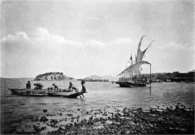
Figure 22.4 Lagatoi trading vessel with smaller canoe loaded with pots, and stilt village over water in background, Port Moresby area (from Lindt 1887)
into chiefdoms with leaders who orchestrated intergroup socio-political dynamics centred on headhunting raids (involving up to 500 men over distances of 200 km) and on complex exchange networks with shell valuables. The power and authority of hereditary chiefs was legitimised and sanctioned by the ancestors whose skulls were venerated at shrines (hope) with valuable shell (poata) votive offerings. Chiefly authority was also enshrined by trophy skulls kept in canoe-houses along with the large war canoes (tomoko) used in the headhunting raids. Hundreds of shrines located around the lagoon track the development of the Roviana chiefdom and regional polity over the past 700 years.[827] Around 400 years ago shrine construction was elaborated considerably to include wharves, canoe-houses, fortifications and hundreds of coral-rubble shrines containing human remains (including ancestor skulls and skulls taken on headhunting raids) and shell valuables.
The enduring presence and power of the dead amongst the living is also illustrated dramatically by Roi Mata's burial site on Retoka Island in Vanuatu. Oral history recalls the burial of Roi Mata, a legendary paramount chief who was interred around 400 years ago, along with about fifty men and women, many elaborately adorned with carved shell and tooth valuables. It is believed that many of the accompanying burials represent sacrificial representatives from various clans brought under Roi Mata's control. The sacrificed men may have been drugged with kava, but it appears the women were buried alive.[828]
Polynesia
Polynesia takes in most of Remote Oceania, and its seafaring pioneers established the last great chapter in the human colonisation of the globe. Archaeologists have discovered that after settling in Tonga and Samoa for at least 1,500 years, descendants of Lapita peoples began migrating to the north, west and south across vast expanses of ocean to establish the more than thirty closely related Polynesian languages and societies we know today. Similarly, many Polynesians today recall in oral histories, traditional stories and songs their ancestral homeland of Hawaiki - taking in Samoa and Tonga and the surrounding islands of Western Polynesia. Similarities in Polynesian societies reflect largely the shallow time-depth (< 1,000 years ago) of their origins in Hawaiki.[829] These similarities include hereditary chiefdoms with communities structured around the chief s extended household, religious structures, commoner households and associated agricultural gardens. Some Polynesian communities also back-migrated westwards into Melanesia (e.g. Tikopia in the Solomon Islands), reinforcing the complex, overlapping and fluid boundary between Melanesia and Polynesia.[830]
Large double-hulled canoes are a distinctive ethnographic feature of Polynesian life and were central to the successful and purposeful open-ocean voyaging that permitted the colonisation of Polynesia.[831] The foundations of Polynesian society emerged in Western Polynesia (Hawaiki) following initial Lapita settlement around 2,900 years ago. As pottery was mostly dropped from the local cultural repertoire by around 1,500 years ago, subsequent colonisers moving out into the remainder of Polynesia were essentially aceramic. The timing of this subsequent dispersal is hotly debated by archaeologists and is complicated by the fact that hard evidence for earliest settlement in the form of artefacts often marginally post-dates putative evidence for the beginnings of human environmental impacts. A recent synthesis argues that the earliest evidence for the settlement of East Polynesia began with movements out to the Society Islands ~1000-900 years ago, followed by the near-instantaneous settlement of the Marquesas, Hawaii and Rapa Nui ~800-700 years ago, and finally New Zealand in the South Pacific Ocean by 700 years ago.[832] Hundreds of subtropical to subantarctic islands were colonised over a rapid phase of a few centuries. At least twenty-five of these islands reveal short-lived occupation and long abandonment by the time of European discovery in the eighteenth and nineteenth centuries.[833] The possible pre-Columbian presence of sweet potato in East Polynesia and Polynesian chickens in Chile suggests Polynesian dispersals may have extended a further 3,000 kilometres east of Rapa Nui to South America.[834] While it has long been considered plausible that Melanesian and Polynesian seafarers reached the east coast of Australia, a lack of archaeological evidence of such visits suggests that viable social relationships were not established with resident Aboriginal peoples.[835] Pottery of apparent Melanesian form found recently on Lizard Island off the north Queensland coast may provide the first solid evidence of such contacts.[836]
Like their Lapita forebears to the west, Polynesian colonisers brought to their new island homes a range of plants and animals to establish culturally modified landscapes suitable for permanent occupation. Pigs, dogs and chickens were selectively moved around the Pacific by people, as were agricultural products such as sweet potatoes, bananas and taro. Some introduced animals, such as the Pacific rat (Rattus exulans), had major unintended impacts on island ecosystems. Indeed, the Pacific rat took such a liking to birds' eggs that it resulted in the extinction of perhaps 2,000 species of birds, representing 20 per cent of the world's bird species.53 The most dramatic example of Polynesian impact on bird populations is New Zealand, where, within 300 years of arrival, ancestral Maori had contributed to the extinction of all species of flightless moa, including the 4-metre-high Dinornis giganteus. Although early New Zealand sites are filled with moa bones attesting to the subsistence importance of moa, it is also clear that forest clearance for horticulture and associated landscape-firing contributed to moa extinction. Indeed, it is estimated that nearly half of New Zealand's forests were transformed into grasslands, fernlands and scrublands by Maori firing practices.54 Apart from clearance for cultivation, landscape-firing was also aimed at promoting the major expansion of bracken fern fields (an important starch food staple). Equally dramatic landscape modification has been documented on Rapu Nui, where by the time Europeans found their way there in the seventeenth century, some twenty species of trees had disappeared in the wake of Polynesian settlement. While such deforestation certainly resulted in new ecological relationships for residents, its causal association with societal collapse has been overstated and the more devastating impacts of European contact underestimated.55
Ethnographic evidence suggests that Polynesians of recent times did not engage in long-distance exchange systems and alliance networks on the same
‘Sourcing Temper Sands in Ancient Ceramics with U-Pb Ages of Detrital Zircons: A Southwest Pacific Test Case', Journal of Archaeological Science 39 (2012): 2583-91.
53 Richard P. Duncan, Alison G. Boyer and Tim M. Blackburn, ‘Magnitude and Variation of Prehistoric Bird Extinctions in the Pacific', Proceedings of the National Academy of Sciences of the United States of America 110 (2013): 6436-41; and David W. Steadman, ‘Prehistoric Extinctions of Pacific Island Birds: Biodiversity Meets Zooarchaeology', Science 267 (1995): 1123-31.
54 David B. McWethy, Cathy Whitlock, Janet M. Wilmshurst, Matt S. McGlone and Xun Li, ‘Rapid Deforestation of South Island, New Zealand, by Early Polynesian Fires', The Holocene 19 (2009): 883-97; and Matt S. McGlone, ‘Polynesian Deforestation of New Zealand: A Preliminary Synthesis', Archaeology in Oceania 18 (1983): 23.
55 Terry L. Hunt and Carl P. Lipo, ‘Revisiting Rapa Nui (Easter Island) “Ecocide”', Pacific Science 63 (2009): 601-16. scale as those documented across Australia and Melanesia.[837] The social structure of Polynesian societies meant that the movement of goods related mostly to gifting at marriages and tribute paid to chiefs.[838] In New Zealand, exchange (especially reciprocal gifting) was more highly developed and was structured in part by ecological differences and focused on foodstuffs and tools (e.g. stone adzes) moving between communities, especially between coastal and inland villages. In some cases, exchange involved prestigious objects, such as those made from greenstone. Archaeological research reveals that adzes made from special sources and quarries of basalt, argillite or nephrite were traded over large areas of New Zealand over the past 700 years.[839] A similarly elaborate exchange system operated historically between Samoa, Tonga and Fiji.[840] Across other parts of Polynesia, archaeological research also reveals that peoples in the ancient past did travel across the ocean moving stone artefacts and pottery between widely spaced communities. For example, during the twelfth to fifteenth centuries, basalt adzes manufactured in the Marquesas were moved across the sea 1,425 kilometres to the Society Islands to the south-west and 1,750 kilometres to Mangareva in French Polynesia to the south-east. Similarly, Hawaiian oral history of voyaging to Tahiti matches geochemical sourcing of a basalt adze found on Napuka, a low coral atoll in the Tuamotu Archipelago of French Polynesia, to Kaho‘olawe in the Hawaiian Islands located 4,000 kilometres or ~32 days' sailing to the north. Basalt adzes and pottery dating to ~600-700 years ago found in the Cook Islands have been sourced to Samoa and Tonga respectively, located 1,700 kilometres to the west.[841] These results are seen to reveal the existence of inter-archipelago interaction spheres operating across central Polynesia up until ~500 years ago, after which island communities became more independent and self-contained.[842]
The hierarchical and stratified nature of many Polynesian societies with paramount chiefs and priesthoods, and monumental stone structures and irrigation works, was elaborated after initial settlement. There is a broad correlation between the degree of socio-political stratification in Polynesian societies and population size and density.[843] Much ceremonial activity (including large-scale tribute offerings) was associated with chiefs, particularly paramount chiefs, who were leaders with spiritual power (mana) descended directly from the gods. While small-scale chiefdoms on atolls involved communities of a few hundred people, the complex stratified paramount chief- doms of Tonga, Samoa, Hawaii and the Society Islands involved polities with tens of thousands of people. These empires were highly territorial and militaristic and represented the most formal and stratified polities and ranked societies developed in Oceania. The historically known Tongan maritime empire involved 30,000-40,000 people and centred on Tongatapuan chiefs exacting tribute from numerous island communities across 800 km2 of sea. Associated monumental structures on Tongatapu include elaborate chiefly tombs using cut blocks of stone weighing up to 50 tonnes and a canoe-wharf complex involving land reclamation and over 100,000 m3 of fill. All of this dates back 500-600 years.[844] In Hawaii, four separate island paramount chiefdoms taking in around 200,000 people were integrated into an empire under the divine kingship of Kamehameha I in the early nineteenth century. The basis of the kingdom, with islands comprising multiple territorial districts (moku) and coterminous chiefdoms collectively ruled by paramount chiefs, emerged ~600-350 years ago.[845] Vast numbers of elaborate stone structures associated with agricultural terraces, irrigation channels, aquaculture ponds and temple complexes (heiau) attest to the monumental dimensions of Hawaiian chiefly power and associated control of resources, labour and ceremonies. On Rapa Nui between ~800 and 500 years ago, chiefs held sway over hundreds of individual coastal territorial districts (kainga) consisting of a village with commoners' houses, houses of the chief and priests, and monumental stone plazas (ahu) upon which were erected huge anthropomorphic stone carvings (moai) weighing up to 80 tonnes. Of the over 500 moai recorded, ~200 remain unfinished in the Rano Raraku basalt quarry. In New
Zealand, with a population of around 100,000 people at European contact, chiefly power and associated militarisation and monumentalism were expressed by the large-scale reforming of hills into some 6,000 elaborately terraced and fortified villages (pa), particularly within the past 400 years.
Micronesia
To the north of Melanesia are the islands of Micronesia, a diverse cultural domain with Austronesian linguistic affiliations with island South-East Asia for the western archipelagos (Marianas and Palau Islands) and with the Pacific for the central and eastern archipelagos (Yap, Caroline, Marshall and Kiribati Islands). Like many other Pacific island societies, Micronesians were marine subsistence specialists in terms of protein (supplemented by introduced pigs, dogs and chickens in some cases) along with introduced crops of taro, yams and breadfruit (and possibly rice in the west). As with Polynesians, Micronesians were master mariners who used elaborately constructed outrigger canoes with sophisticated sails, rigging and navigational systems to voyage between islands and across the ocean. The political arrangement of villages focused on extended family households with various degrees of social ranking, including hereditary chiefs.
The history of human occupation of Micronesia is recent (wooden buildings to house people and even large canoes. The association of burials of men and women with many latte in coastal settings suggests a connection with ancestral power and territoriality. Sourcing of stone artefacts reveals some inter-island exchange and social relationships between various latte communities. The famous large-scale monumental structures at Nan Madol on Pohnpei are associated with expanding chiefly architecture and centralised political control legitimated by ancestors (Fig. 22.5). The site complex consists of ninety-three artificial islets resting on fringing reef that were constructed variously between about 1,500 and 800 years ago, with major use ceasing around 400 years ago. The basalt structures include walls up to 9 metres high, elite tombs of ancestors, and residences of chiefs and their specialist 66
entourages.
66 J. Stephen Athens, ‘The Rise of the Saudeleur: Dating the Nan Madol Chiefdom, Pohnpei', in Atholl Anderson, Kaye Green and Foss Leach (eds.), Vastly Ingenious: The Archaeology of Pacific Material Culture in Honour of Janet M. Davidson (Dunedin, New Zealand: Otago University Press, 2007); and Rainbird, The Archaeology of Micronesia.
That many of the islands of Micronesia were connected through social alliances and associated exchange networks is exemplified by the so-called Yapese Empire. The paramount chief of the Gagil district of Yap controlled an exchange system known as sawei that included fifteen atoll communities located across 1,300 kilometres of ocean and the Caroline Islands.[847] Sawei is the largest historically known exchange system in Micronesia and included items such as shell valuables, fibre shirts, rope and turtle-shell belts coming into Yap and items including ceramic pots, pigments, clam shells and turmeric used in ceremonies and a broad range of foodstuffs coming out ofYap. This reciprocal exchange system created social relationships and alliances between widely separated communities, which, inter alia, allowed groups to draw on neighbouring groups during food shortages. Another exchange network linked Yap to islands to the west, including Palau, where limestone was quarried to carve into small and large discs which were canoed over 300 kilometres across to Yap as a form of ‘stone money'. Intensified movement of Yapese pottery across the Caroline Islands around 600 years ago may mark the beginnings of the sawei exchange system.[848]
Conclusion
The human history of Oceania ranges from at least 50,000 years ago in Australia/New Guinea to a mere 700 years in New Zealand. Despite the vastly different types of societies that developed across Oceania, all had in common various degrees of interactions with neighbours near and far. The histories of these exchange systems and associated social networks provide important and revealing insights into historical developments and changes within and between communities, and into people-people and people-environment relationships. Whereas in the Pleistocene, long-distance exchange systems were developed in part in response to low population densities and highly dispersed communities, in the late Holocene the development of systems of exchange related more to the management of high population densities and frequent contact between numerous, contiguous communities. In many cases, such networks and alliances were strategic developments to help obviate risks associated with environmental fluctuations and resource stress. The high level of secular, religious and ritual knowledge and energy required to orchestrate, manage and control such complex social relations required skilled leadership and provided the basis for authority. Thus for Aboriginal Australians, population increases and intensified social interactions of the past 3,000 years paralleled increasing social complexity and hierarchy expressed materially through objects associated with exchange and rituals, and sites associated with social gatherings, ceremonies and feasting. Similar developments also took place amongst agricultural island societies of Melanesia, Polynesia and Micronesia over the past 3,000 years, but elaborated to include more energy-consuming and formalised hierarchical structures and labour-intensive monumental ceremonial sites to support chiefly elites and help manage high population densities and numbers. Whereas governance in Aboriginal societies centred on acquired status and leadership based upon negotiation skills and the strategic use and control of secular and religious knowledge and resources, in Remote Oceania governance was specialised, institutionalised, hierarchical and usually involved hereditary chiefs. These were the worlds encountered by the British explorer and master mariner Lt. James Cook as he sailed through the Pacific on his voyages of discovery in the late eighteenth century.
Further Reading
Akerman, Kim, and John Stanton, Rtji and Jakuli: Kimberley Pearl Shell in Aboriginal Australia, Monograph Series 4, Darwin: Northern Territory Museum of Arts and Sciences, 1994.
Bahn, Paul G., and John Flenley, Easter Island, Earth Island, London: Thames and Hudson, 1992.
Ballard, Chris, Paula Brown, R. Michael Bourke and Tracy Harwood (eds.), The Sweet Potato in Oceania: A Reappraisal, Oceania Monographs 56, University of Sydney, 2005.
Brown, Paula, Highland Peoples of New Guinea, Cambridge University Press, 1978.
David, Bruno, Landscapes, Rock-Art and the Dreaming: An Archaeology of Preunderstanding, London and New York: Leicester University Press, 2002.
Frankel, David, and Jim Rhoads (eds.), Archaeology of a Coastal Exchange System: Sites and Ceramics of the Papuan Gulf, Research Papers in Archaeology and Natural History 25. Canberra: Division of Archaeology and Natural History, Research School of Pacific and Asian Studies, The Australian National University, 1994.
Hiscock, Peter, Archaeology of Ancient Australia, London and New York: Routledge, 2008. Howe, Kerry R. (ed.), Vaka Moana: Voyages of the Ancestors, Auckland: David Bateman Ltd and Auckland Museum, 2006.
IANJ. MCNIVBN
Hughes, Ian, New Guinea Stone Age Trade, Terra Australis 3, Canberra: Department of Prehistory, Research School of Pacific Studies, The Australian National University, 1977.
Irwin, Geoff, The Prehistoric Exploration and Colonisation of the Pacific, Cambridge University Press, 1992.
Jones, Terry L., Alice A. Storey, Elizabeth A. Matisoo-Smith and Jose M. Ramirez-Aliaga, Polynesians in America: Pre-Columbian Contacts with the New World, Lanham, md: AltaMira Press, 2011.
Keen, Ian, Aboriginal Economy & Society: Australia at the Threshold of Colonisation, South Melbourne: Oxford University Press, 2004.
Kirch, PatrickV., The Lapita Peoples: Ancestors of the Oceanic World, Oxford: Blackwell, 1997. On the Road of the Winds: An Archaeological History of the Pacific Islands before European Contact, Berkeley: University of California Press, 2000.
Lilley, Ian (ed.), Archaeology of Oceania: Australia and the Pacific Islands, Carlton, Vic.: Blackwell, 2006.
Lourandos, Harry, Continent of Hunter-Gatherers: New Perspectives in Australian Prehistory, Cambridge University Press, 1997.
Macfarlane, Ingrid, Mary-Jane Mountain and Robert Paton (eds.), Many Exchanges: Archaeology, History, Community and the Work of Isabel McBryde, Aboriginal History Monograph ιι. Canberra: Aboriginal History Inc., 2005.
McNiven, IanJ., and Lynette Russell, Appropriated Pasts: Indigenous Peoples and the Colonial Culture of Archaeology, Walnut Creek, ca: AltaMira Press, 2005.
Morwood, MichaelJ., Visions from the Past: The Archaeology of Australian Aboriginal Art, St Leonards, NSW: Allen & Unwin, 2002.
Oliver, Douglas L., Oceania: TheNative Cultures of Australia and the Pacific Islands, vols. i and ii, Honolulu: University of Hawai'i Press, 1989.
Peterson, Nicholas (ed.), Tribes and Boundaries in Australia, Canberra: Australian Institute of Aboriginal Studies, 1976.
Rainbird, Paul, The Archaeology of Micronesia, Cambridge University Press, 2004.
Sand, Christophe and Stuart Bedford (eds.), Lapita: Oceanic Ancestors, Paris: Musee Du Quai Branley, 2010.
Smith, Mike, The Archaeology of Australia’s Deserts, Cambridge University Press, 2013.
Spriggs, Matthew, The Island Melanesians, Oxford: Blackwell, 1997.
Summerhayes, Glenn, Lapita Interaction. Terra Australis 15, Canberra: Archaeology and Natural History Publications, 2000.
Thomson, Donald F., Economic Structure and the Ceremonial Exchange Cycle in Arnhem Land, Melbourne: Macmillan & Co., 1949.
Tindale, Norman B., Aboriginal Tribes of Australia, Berkeley: University of California Press, 1974.
Van Tilburg, Jo Anne, Easter Island: Archaeology, Ecology and Culture. London, British Museum Press, 1994.
Weisler, Marshall (ed.), Prehistoric Long-Distance Interaction in Oceania: An Interdisciplinary Approach, Monograph 21, Auckland: New Zealand Archaeological Association, 1997.