Regional study: Chaco Canyon and the US Southwest
STEPHEN H. LEKSON
Chaco Canyon in northwestern New Mexico, with its monumental eleventh-twelfth-century ce “Great Houses,” is one of the most famous archaeological sites in the US Southwest.
Chaco is one of three UNESCO World Heritage Sites in the region, the others being the thirteenth-century cliff-dwellings of Mesa Verde in Colorado and the Indian Pueblo of Taos, a living village in northern New Mexico. (A fourth “southwest” World Heritage cultural site, Paquime in Chihuahua, Mexico, will be discussed below.)In the Southwest, ancient ruins and Native villages blend seamlessly. Adolph Bandolier's pioneering explorations in the late nineteenth century more or less defined Southwestern archaeology. He was instructed by his mentor, Lewis Henry Morgan (“the father of American anthropology”), that “the facts of American archaeology must be studied ethnographically: i.e., from the institutions, usages, and mode of life of the existing Indian tribes.”[753] That is: understand the ancient past by direct reference to the Pueblo Indian present. That strategy underwrote Southwestern archaeology for over a century, and underwrites much of our thinking today.
Connections between ruins and Pueblos are reinforced by current heritage concerns of modern Pueblo Indians. Themes of continuity and changelessness run through almost every account of the Pueblos, whose institutions, usages, and modes of life are often said to date to Time Immemorial. Pueblo traditional histories, in contrast, are all about movement, migration, and change. For the last five centuries, however, Pueblo Indians maintained highly traditional communities in small towns (or “pueblos”), Native enclaves within Spanish, Mexican, and American states and empires. Archaeology (and Pueblo traditional histories) tells us that modern Pueblo societies developed from a very different past, after the fall of Chaco and Mesa Verde; that is, after 1300 ce.
To be sure, the forty or so modern Pueblo Indian towns (from Hopi, Arizona, on the west to Taos, New Mexico, on the east) are descendant communities of most, but perhaps not all, of the people who built the cliffdwellings and Chaco. Very likely, not all of the people who built Chaco and - more importantly - not all of their social and political institutions, usages, and modes of life survive in modern Pueblos. The history of the ancient Southwest was as much about change as continuity. Chaco may be the most important site in Pueblo Indian prehistory: a transformative episode that clearly was NOT “Pueblo” in its social and political organization, but which served as a historical “cause” of modern Pueblos, when Pueblo peoples consciously rejected the Mesoamerican-inspired hierarchies and governments of Chaco and developed the egalitarian, communal, ritually based societies seen today at Taos, Hopi, and other Pueblos.
Chaco, although its history falls slightly earlier than the period covered by this volume, serves well as a case study of world history in ancient North America. The ancient societies of North America were densely interconnected in ways that shaped history - a New World history. North American archaeology, however, was founded on the idea that Native societies north of Mexico were simple, isolated, and essentially history-less. Those notions reflected eighteenth- and nineteenth-century colonial and racist biases, painting North American Natives as “savages” unworthy of their continent. While contemporary American archaeology is anything but colonial or racist - absolutely, it is not! - those inherited foundational principles continue to define the intellectual “space” in which archaeology is conducted. It is assumed, a priori, that even the most elaborate North American societies were “intermediate” - far short of “states” with formalized, institutional governments.[754]
Reconnecting Chaco and the ancient Southwest with its contemporary world - specifically, Mesoamerica - re-situates the region on a continent awash with states and empires.
Chaco demonstrates the critical need for such a reconfiguration. Other obvious Southwestern examples include Hohokam and Paquime. Hohokam was the non-Pueblo civilization of southern Arizona, contemporary with and in many ways more impressive than Chaco.[755] Hohokam clearly referenced the civilizations of western Mexico, to a degree that many archaeologists see a direct intrusion of west Mexican peoples as stimulus to Hohokam’s rise, starting around 700 ce - an explosive event that, in its turn, may have precipitated the rise of Chaco. (Hohokam built without stone; thus, their ruins are flattened and unimpressive, and their history remains largely untold by national parks, coffee-table books, or educational media.) Fourteenth-century Paquime was the Southwest’s last and greatest city, with “!"-shaped Mesoamerican ball courts, small “pyramids," and a plethora of Mesoamerican references and connections. We shall meet Paquime again, below, as a possible heir of Chaco.The US Southwest and Mexico
The Southwest is a well-known region - and a major cultural heritage theme- within the United States, comprising the states of New Mexico, Arizona, and the southern portions of Colorado and Utah. As a cultural and archaeological region, the Southwest is partly an accident of history and partly a deliberate colonial creation - and, of course, partly real. History first: US President Polk’s ambitions to expand his country to the Pacific Coast triggered a war with Mexico (1846-1848). The United States won, and Mexico’s Noroeste became the USA’s Southwest. An influx of Americans followed, colonizing the new territories. By the late nineteenth century, transplanted Americans came to appreciate the tourism potential of the Southwest’s Hispanic and Native societies. !n a spectacular natural landscape, old Hispanic villages and older !ndian Pueblos appealed to Americans as an exotic “foreign country" tucked safely within the national boundaries.
!n the early 1900s, a small cabal of community leaders, archaeologists, journalists, and artists - mostly in Santa Fe and Taos - created and marketed a highly romanticized Southwest. !t worked: tourism became an enormous economic force in the region.Archaeological ruins were an important part of the package. American armies noticed ruins during the Mexican War. Local legends ascribed them to the Aztecs: the northern Aztlan homelands from which Aztecs began their march south to empire. Initial newspaper descriptions of the new Southwest accepted that view: the ruins were Aztec. The mysterious cliff-dwellings of Mesa Verde, revealed to the world in the late nineteenth century, fueled speculation about a lost race - probably Aztecs. New towns and counties were named Aztec, Toltec, and Montezuma.
Adolph Bandelier (the region's first archaeologist, met briefly above) directly addressed the Aztec question and concluded that the Southwest's ruins were antecedent to Pueblo Indian peoples; they had no connection with the glories of old Mexico.[756] Southwest prehistory was presented as fundamentally local, with a slow, steady (Bandelier said “tedious”) progression from hunter-gatherers accepting, at many removes, a diffused maize agriculture and (perhaps) pottery from the south, then evolving in-place to become the simple, isolated farming societies of the modern Pueblos. That progression was codified in 1927 at a field conference held at the ruins of Pecos Pueblo. The new master chronology was called “the Pecos System”: a series of numbered, additive stages from pre-pottery Basketmaker I, II, and III continuing through Pueblo I, II, III, IV, and V - “Pueblo V” being the modern Pueblos. At each stage, another element of modern Pueblo life was added (maize, pottery, pueblos, kivas, kachinas, etc.), until, by 1450 ce, Pueblos emerged more or less as encountered by the Spanish conquistadors and American anthropologists. The region's agricultural staples and economic base - maize, beans, squash - surely came from Mexico, but they arrived, by this account, without significant cultural baggage.
Thus, the Southwest's ancient history was effectively nationalized by the war of conquest, colonial commercialization, and early archaeology.The ancient Southwest, we felt, should remain local, within the national jurisdiction. With more excavations, Southwestern ruins revealed evidence for contacts and influences from the south, but these were minimized. Carl Sauer, the great Berkeley cultural geographer, wondered about all this:
The notion of the independence and isolation of Southwest Culture would not have arisen, it seems to me, if, historically, Mexico had been the center from which anthropological studies had spread into North America. Scholars, coming into the Southwest from the North, have realized that they were getting into something strongly different, and yet their curiosity stopped at the International Border, and they have failed to see how much of this complex has, even in ancient times, moved into the Southwest from the South. Indeed, notions about the origins of Southwest Culture originated in the years when it was considered proper to infer endemism as dominant in cultural studies, to maximize development in situ, and minimize the significance of dispersal and diffusion. A familiar example is the [Pecos System's] postulated succession of stages from Basketmaker I to Pueblo V, all of this construed as the product of autochthonous “evolution.”[757]
Sauer was correct: the Southwest was, historically, the northwestern frontier of Mesoamerica. But, as discussed further below, the Southwest was, to a degree, geographically distinct, much as the Intermediate Zone on the southern fringes of Mesoamerica differed from the civilization's core. Spanish colonial exploration established the Southwest as something of an island or isolate of Neolithic civilization spatially remote from its mother cultures in Mesoamerica. The Southwest's last and greatest city, Paquime in Chihuahua (of which, more below), was 600 km north of Mesoamerica's northernmost city, Culiacan in Sinaloa (of which, more below).
When the Spanish arrived, that 600 km gap was populated by nomadic or “uncivilized” (that is, non-urban) tribes. In the Southwest they found “pueblos" - settled agricultural towns. Thus, there is a glimmer of validity to its regional distinction - the Southwest was, in part, real - an isolated frontier.A carefully managed provincialism reinforced early anthropology's bedrock assumptions that all North American Native societies - including Southwestern Pueblos - were, and always had been, simple and “intermediate.” A panel of distinguished archaeologists considered the ancient Pueblo Southwest and concluded “we can't even pretend [they] formed states.”[758] For many decades, the ruins of the Southwest - the cliff-dwellings, Chaco Canyon, and hundreds of others preserved in national and state parks - have been interpreted as early versions of modern Pueblos: simple, egalitarian, and communal.
Chaco was not that. Chaco was a “state" - a secondary state, a local version of a Mesoamerican polity. It failed. Around 1300 ce, Pueblo people rejected Chaco's political structure. They made a conscious, historical decision to be simple, egalitarian, and communal. Pueblo people never again built - or allowed - anything like Chaco.
Archaeology at Chaco Canyon
Some terminology: “Anasazi” is an archaeological term, anglicized from a Navajo phrase, for the ancient peoples of the Four Corners region in New Mexico, Colorado, Utah, and Arizona. For many decades, technical and popular writing used “Anasazi”; I use it here in its archaeological sense. Many archaeologists and Natives prefer “Ancestral Pueblo,” with its implication of Pueblo cultural affiliation. While there can be no question that modern Pueblos are descendent communities of Chacoan societies, the equation may not be so simple: Navajo people (unrelated to Pueblos) know a lot about Chaco, and (as suggested above) key elements of Chaco are not represented in modern Pueblos, except as traditions and histories.
Chaco's apogee was “the Bonito phase,” dating from about 850 to 1150 ce, named after the canyon's largest ruin, Pueblo Bonito (of which, more below). Pueblo Bonito is the iconic, archetypical “Great House,” huge masonry buildings with hundred of rooms standing four or five stories tall, which constitute Chaco's principal interest. Great Houses stand in contrast with normal family homes of their times, the small “unit pueblos” consisting of a pit structure backed by a few small above-ground rooms. (Family homes of Chaco's time were remarkably modular, thus “unit pueblo.”)
Without Great Houses, there would be no Chaco Culture National Park, no “Chaco Phenomenon,” no almost fetishistic archaeological interest in Chaco Canyon. I use “Chaco” for the archaeological phenomenon which occurred in Chaco Canyon, and for the “regional system” which extended far beyond the canyon itself.
Archaeologists have excavated at Chaco Canyon for more than a century. Richard Wetherill, the cowboy-archaeologist who discovered Mesa Verde, initiated excavations at Chaco in 1896, at its marquee site of Pueblo Bonito. His was the first of several major field projects sponsored by a variety of institutions: the American Museum of Natural History (with Wetherill) at Pueblo Bonito (1896-1900), the Smithsonian Institution and National Geographic Society at Pueblo Bonito and Pueblo del Arroyo (1921-1927), the Museum of New Mexico and the University of New Mexico at Chetro Ketl (1920-1934), and the National Park Service (NPS) at Kin Kletso (1950-1951). The last major field program, the NPS's Chaco Project, worked at Chaco from 1971 to 1982. And now Chacoan archaeology has come full circle: in 2005-2006, the University of New Mexico reopened old National Geographic Society trenches in front of Pueblo Bonito, in the “Chaco Stratigraphy Project" - a re-analysis already producing significant results.
Lots of archaeology has been done at Chaco. That investment of time, money, energy, and brains returned remarkable results, multiplied by several factors: aridity and superb preservation; surface visibility, with scant plant cover and little later superimposition; tree-ring dating (Chaco, with tens of thousands of precise tree-ring dates, may be the best-dated prehistoric site in the world); and a short, simple sequence (compared with Troy or Tenochtitlan). Doing archaeology at Chaco is relatively easy, and many excellent archaeologists worked there over a long time. With all that high-quality work at an advantageous site, we should know a lot about Chaco. We do.
Chaco Canyon
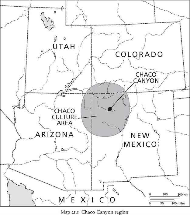
Chaco Canyon is at latitude 36° north, longitude 108° west, in northwestern New Mexico. At Pueblo Bonito, the elevation is about 1,865 m (6,125 ft). The heart of the canyon is a 12-km-long stretch with the intermittent Chaco Wash running from east-southeast to west-northwest. The north side of the canyon has towering sandstone cliffs topped by wide “slick rock” terraces; the south side is less dramatic. The canyon is near the center of the SanJuan Basin, a vast geological depression that takes in most of northwestern New Mexico and adjacent portions of Colorado. Archaeology borrowed that name from geology and refashioned it to define a region about 100 km in radius around Chaco, comprising the Chaco River drainage and nearby portions of the SanJuan River, into which the Chaco flows - when it flows (see Map 21.ι).
The very largest Great Houses were concentrated in a 2-km-diameter “downtown” zone at the center of Chaco Canyon. These include Pueblo Bonito (described below), Pueblo Alto, Chetro Ketl, Pueblo del Arroyo, Kin Kletso, and many other monuments and smaller structures. Architecture extends beyond this central zone to what has been called the “Chaco Halo,” an oval area with a maximum radius from Pueblo Bonito of about 8.5 to 10 km beyond the confines of the canyon. Beyond the Chaco Halo lay the boundaries of the SanJuan Basin, often considered Chaco's inner core - a radius around Pueblo Bonito of about 70 km. The scale of Chaco's world was even larger, however, extending over much of the Four Corners region, as far as 150 km from Chaco Canyon.
Chaco Canyon's environment was harsh - a description overused in Southwestern archaeology but singularly applicable here. Summers are blisteringly hot; winters are wretchedly cold. The growing season is short, and
rainfall uncertain. Indeed, water for basic domestic needs is (and was) a concern. The canyon contained little wood for building or burning, and no outstanding local resources besides sandstone and low-grade coal (which was not used). The canyon was a poor place to farm, only marginally better than the surrounding desert; much or most maize (the staple crop, along with beans and squash) was imported from better-watered areas around the edge of the SanJuan Basin.[759] How and why did Chaco's spectacular Bonito phase flourish in this desert canyon, when well-watered valleys lay empty to the north and south, closer to mountains and forests? Clearly, part of the answers to those questions must be sought outside the canyon itself, in the larger region of which Chaco was the center.
The Bonito phase, in and beyond Chaco Canyon
Chaco Canyon is not a single “site”; indeed, there are several hundred prehistoric ruins in the national park. In barren Chaco, early archaeology couldn't see the forest for all those trees. Pueblo Bonito (see Fig. 21.ι) and Chetro Ketl were considered separate sites; but those Great Houses and many other sites in the canyon constituted a single urban or nearurban settlement. Chaco's “city-scape” was composed of a number of different types or classes of structures and monuments, ranging from huge “Great Houses” to modest family homes (technically, “unit pueblos”), as well as “roads,” Great Kivas, mounds, platforms, waterworks, and other building types. This section briefly reviews these forms, and then discusses their larger setting: the urban center at Chaco and its larger region.
The archaeology of Chaco Canyon centers on a dozen remarkable buildings called “Great Houses.” Great Houses at Chaco began in the late ninth century as monumentally up-scaled versions of regular domestic structures, “unit pueblos” - the small, single-family home or, more prosaically, “small sites.” Early Great Houses were unquestionably residences: Great Houses. It is important to remember that Great Houses began, and continued, as residences - a key fact obscured by the addition of monumental masses of non-domestic architecture, as Great Houses developed over the next three centuries.
In Chaco's region, there were scores of unit pueblos for every Great House. The differences were unmistakable. An entire unit pueblo, compressed to its floor area, would fit in a large room at a Chaco Great House. Unit pueblos - homes of the people - and Great Houses - elite residences - constitute one of the clearest examples of stratified housing in archaeology, Minoan in its clarity. In Mesoamerican terms, Great Houses were the palaces of noble families; unit pueblos were the farmsteads of commoners. Those terms seem untoward for North America, which we have long been told was always simple and “intermediate”; but palaces, nobles, and commoners almost certainly accurately describe Chaco.
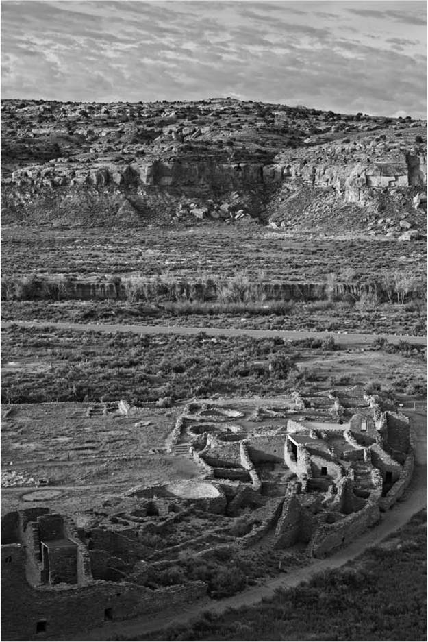
Figure 21.ι Pueblo Bonito and sandstone bluffs, Chaco Culture National Historical Park, New Mexico, USA (Efrain Padro / Alamy)
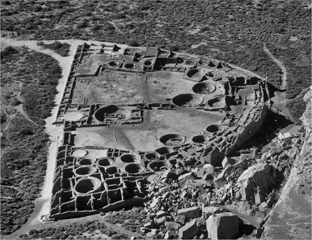
Figure 21.2 Aerial view of the ruins of Pueblo Bonito, Chaco Culture National Historical Park, New Mexico, USA (Manfred Gottschalk / Alamy)
Shortly after 1000 ce, Great Houses took a canonical turn in form and function: they became monuments, in addition to elite residences. The organic, curved plans of earlier Great Houses were replaced by precise, formal geometries. Great House plans are typically described by letters: “D”-shaped, “E”-shaped, and so forth. Vastblocks of storage rooms, disproportionate storage to the relatively small numbers of residents, were added; as were monumental public and official spaces. Most of Chaco's Great Houses were built along the north side of the canyon in little over a century, from 1020 to about 1125 ce; but each Great House has a unique construction history and several started much earlier. Pueblo Bonito was one of the earliest Great Houses and is typical - perhaps archetypical - of Chaco Canyon Great Houses (see Fig. 21.2).
Pueblo Bonito took almost three centuries (850 to 1125) to build. At every stage of construction, it was a monumental sight. The “roads” of ancient Chaco (described below) led visitors to the edge of Chaco's sheer sandstone cliffs, overlooking Bonito's huge D-shaped ground plan. The building began as a “scaled-up” version of unit pueblos, built three stories tall (normal unit pueblos were a single, short story). Anasazi masonry of 850 ce was inadequate for multiple stories, so, when the rear wall of Pueblo Bonito began to fail in the early eleventh century, Chaco architects buttressed the old building by enveloping it in an exterior curtain wall of superior stonework - some of the earliest fine masonry for which Chaco is famous. In other cases, Chaco builders razed and replaced existing sections of Great Houses (including parts of Pueblo Bonito), but the original core of Pueblo Bonito remained at the heart of the structure throughout its long history.
Beginning about 1020 ce, the architects of Pueblo Bonito started a series of six major additions, each of which was enormously larger than anything previously built in the Pueblo world. At the culmination, about 1125 ce, almost 700 hundred rooms, massed up to four and perhaps five stories tall, covered an area of about 0.8 hectares (2 acres). Only the outermost shell of Pueblo Bonito's rooms had direct sunlight; most interior rooms were dark and had limited access, suited (presumably) for storage. Only a score of families lived in this huge building.[760] They were important families who controlled, or at least had access to, vast blocks of storage and non-domestic rooms.
Like other Great Houses, Pueblo Bonito was expensive and laborious to build. That is, the labor-per-unit measure of floor area or roofed volume far exceeded that for unit pueblos - built and maintained by their resident families. Labor on monumental scales was organized and coordinated for site preparation (leveling and terracing); extensive foundations; massive, artfully coursed masonry walls; over-timbered roofs and ceilings (hundreds of thousands of large pine beams brought from distant forests); skillful carpentry, which can only be appreciated today from masonry remnants of elaborate wooden stairways, balconies, and porticos; and other monumental features and furniture unique to these remarkable buildings. Among these were colonnades (a Mesoamerican form, found only at Chetro Ketl); unique raised shelf-platforms (for storage or sleeping) within rooms at most Great Houses; and large sandstone disks (approximately ι m diameter and 30 cm thick) stacked like pancakes as foundations or dedicatory monuments beneath major roof-support posts of Great Kivas (described below).
Great Houses served the dead as well as the living. The earliest part of Pueblo Bonito, the cluster of earliest rooms at the center of the building, became a mausoleum for elite burials. Two high-status middle-aged men - perhaps the building's founders - were buried 850 C e with great wealth in wooden crypts beneath the building's floor.[761] These honored dead defined one aspect of the Great House's monumentality. Later construction preserved the early core with its burials, enveloping the older masonry in better and better-built blocks of rooms. Many more elite deceased were later richly interred in the oldest parts of the building.
In contrast, burials at unit pueblos were typically in middens fronting the homestead, accompanied by a pot or two. Scores of unit pueblos and aggregates of such units - commoner homes - lined the south side of the canyon. These homes were identical to farmsteads throughout Chaco's region and in regions beyond Chaco's reach: single (extended) family homes, largely self-sufficient, clustered into scattered communities of a few dozen unit pueblos and with a central Great Kiva, with perhaps 60 to 655 total population.[762] That was the social scale of Anasazi settlement, before Chaco.
Life at a Great House differed in almost every way from life at a unit pueblo. Unit pueblos were built and maintained by the family it housed, with some help no doubt from close relatives. (During Chaco's era, farmsteads increasingly relied on an organized bulk-trade in pottery and foodstuffs.) The few elite families who actually lived in Pueblo Bonito could not, and did not, build it themselves. Impressive amounts of labor were required to build the huge structure, labor recruited from far beyond Chaco Canyon itself. Commoners from Chaco's unit pueblo may have done much of the domestic work that kept Pueblo Bonito running. At Pueblo Bonito and other Great Houses, rooms lined with batteries of maize-grinding metates (milling stones) and huge ovens in plazas suggest that teams prepared meals for larger groups. Feasting, no doubt: by elites and their followers; or in public ceremonies cementing the elite's position in society.
Chaco's Great Houses were by far the largest structures of their times in the Southwest, and Pueblo Bonito was the largest Great House. Great Houses were not the largest pueblo-style sites ever built in the Southwest, however; four centuries after Chaco, Rio Grande villages were much larger than Pueblo Bonito alone (which would fit in the present plaza of Taos Pueblo). Great Houses were anomalous because they were the first architectural masses of their size, unique in their time; and because they were not single sites: Great Houses at Chaco - huge as they might be - were elements in a much larger site, Chaco Canyon itself.Taos is a town; Chaco Canyon, with its many Great Houses, was a city.
Pueblo Bonito was only one of a half-dozen major Great Houses at Chaco. There were many smaller Great Houses, mostly built on the north side of the canyon. Great Houses were part of a large, complex settlement; in effect, a city (described below). “Downtown” Chaco as a built environment or city-scape encompassed many other elements, such as roads, mounds, Great Kivas, waterworks, and, on the south side of the canyon, hundreds of unit pueblos. Chaco's constituent elements are briefly described below.
Roads appear much as their name implies: long, straight, wide (typically 9 m) carefully engineered earthen features. Leveled and bermed, they linked sites to other sites and to natural places. Chaco roads were simpler in construction but not unlike the causeways of slightly earlier La Quemada on the northern edge of Mesoamerica proper, and the more distant sacbe of the Maya.[763] Chacoan roads were designed for foot traffic - no beasts of burden, no wheeled vehicles - presumably in wider conformations than could be accommodated on the ubiquitous narrow footpaths that crisscrossed the region. Where roads met cliffs, they constructed wide, elaborate ramps, or carved wide stairways with deep treads and tall risers out of the living rock. Where quotidian footpaths met a cliff, staggered lines of chipped hand- and toe-holds sufficed. Roads were meant for masses of people (pilgrimage), or people in regalia, or even perhaps for troops. The symbolic or monumental aspects of roads were as (or more) important than their utilitarian roles: the dense network of roads in downtown Chaco, for example, created redundant, parallel routes clearly unnecessary for efficient pedestrian use. Roads symbolized, monumentally, political and historical connections between places. Those roads meant something beyond simple transportation.
Many roads ran out from Chaco, like spokes on a wheel. Some lead to distant Great Houses; others lead to important natural features. Road systems converged on Chaco Canyon, suggesting a division of Chaco's hinterlands into “pie-slices” answering to particular Great Houses around “downtown” Chaco. Many of the regional roads were formally constructed only at their termini, where they approached or entered Great House complexes. At an “outlying” Great House, a road segment pointing back toward Chaco was perhaps all that was necessary: the missing middle parts were simply understood. An elaborate and extensive line-of-sight communication system, with signal fire stations atop high points, paralleled the road system, allowing information to pass from Chaco to the edges of its region, and back again via “repeater” stations, relatively quickly. We know nothing of the relative sophistication of the communication system. Perhaps it was as simple as yes/no, plus/minus, but given the sophistication of later fire signaling systems in North America, it seems likely that messages of some complexity could be transmitted.
Earthen mounds and masonry platforms encompassed a range of solid structures with (presumably) a variety of purposes. Most mounds were oval, sculpted accumulations of earth, trash, and construction debris. A few mounds have very formal geometric shapes. In front of Pueblo Bonito were two large, head-high, rectangular, masonry-walled, platform mounds, each larger than a basketball court. Stairs led up to their heavily plastered surfaces. We do not know what structures, if any, stood on these platforms. Other earthworks include large berms running alongside roads and huge “trash mounds” or middens at some (but, importantly, not all) Great Houses; these, too, were probably more architectural than depositional.
The north side of Chaco Canyon was lined with small-scale waterworks, capturing rare rainfall in bedrock reservoirs atop the cliffs, and then channeling that water to small fields. These systems have been interpreted as subsistence infrastructure but, given the poor agricultural prospects and the clear monumentality of Chaco Canyon, it seems possible that water was an element of landscape or city-scape architecture, with gardens between Great Houses. Consider the impact on a visitor, after traveling 50 km or more over the barren San Juan Basin, of waterworks in Chaco: a statement of power over the elements. What was grown in Chaco's gardens? We can only speculate. Maize, to be sure, but perhaps of symbolic value, not for eating. And perhaps other non-subsistence plants: reeds, flowers, and other aquatic vegetation.
Great Kivas were large, round, massively roofed subterranean chambers up to 20 m or more in diameter, with an encircling bench presumably to seat audiences for ritual or other performances. The bench would accommodate up to 150 people. Great Kivas had a very long history in Anasazi building, both before and after Chaco, as community centers; but at Chaco Canyon they were built with the same monumental skills and scales of Great Houses.
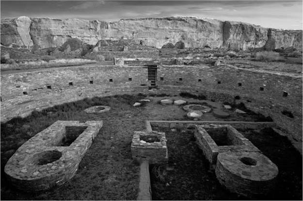
Figure 21.3 Great Kiva Chetro Ketl, Chaco Culture National Historical Park, New Mexico, USA (Dale O'Dell / Alamy)
Chacoan Great Kivas formed a class apart. It has been suggested that Chaco “captured” the Great Kiva form from its original community functions, appropriating and redefining it as part of the Chacoan polity (see Fig. 21.3).[764] [765]
The artifacts of Bonito phase in Chaco Canyon, with some very notable exceptions, are those of contemporary Anasazi pottery and lithic industries. While the vast majority of Chaco artifacts were not exceptional, their origins were. Many were manufactured in other Anasazi districts; for example, communities up to 50 to 60 km distant made most of the pottery found at Great Houses in Chaco. Within approximately 150 km radius, bulk goods - timbers, pottery, probably maize and meat - moved into (and perhaps back out of) Chaco Canyon. 13
Great Houses contained many exotic, unusual, or even unique objects. For example, an intriguing class of ceramic vessels was found almost exclusively at Chaco. Two rooms in Pueblo Bonito contained most of about 200 known cylinder vases, resembling Mesoamerican forms. Chaco Canyon, particularly Pueblo Bonito, is notable for very long-distance imports. About thirty-five copper bells and an equal number of scarlet macaws, all presumably from western Mexico, were found at Chaco. Macaws found at Pueblo Bonito might well have provided feathers for regalia found 250 km away - Chaco's farthest reach - in southeastern Utah. Recently, cacao - a tropical beverage reserved for Mesoamerican elites - has been detected in Bonito's cylinder vases.[766] Chaco had more “exotica” than any other eleventh-century site and, indeed, more than all other excavated sites of Chaco's times, combined.
Turquoise, too, is conspicuous at Chaco Canyon and especially at Pueblo Bonito. Some estimates place the number of recovered pieces at more than 100,000, mostly in the form of small disk beads in elite burials. Many small and large sites at Chaco Canyon contained workshops for the manufacture of turquoise beads, but the source of the stone was not local: there were no turquoise sources near Chaco Canyon. The huge Cerrillos turquoise mines, 190 km southeast of Chaco near Santa Fe, New Mexico, are clearly implicated in Chacoan production of turquoise, and the gemstone was acquired from many other mines in the western United States. Southwestern turquoise, almost certainly from Chaco workshops, was a major export to Mesoamerica, shipped as tesserae (small rectangular plaques) which were then used in the creation of mosaic-covered objects.[767]
Thus, the Bonito phase extended far beyond the confines of Chaco Canyon: 150 km radius defined Chaco's inner circle; 250 km its outer reach; and Mesoamerica its distant trading partner. Chaco was the center of a large “regional system,” about 80,000 sq. km (30,000 sq. miles; the size of Ireland), defined by about 150 smaller “outlier” Great Houses, road networks, and line-of-sight signaling systems. The nature of that regional system is a matter of much debate.
Small “outlier” Great Houses used the same techniques and design principles as Chaco Canyon Great Houses, but the outliers were typically about
Regional study: Chaco Canyon and the US Southwest one-twentieth the size of Pueblo Bonito or Chetro Ketl - as if a portion of those giant buildings had been cut away and transplanted up to 250 km away. Almost always, the Great House sat amid (and usually, above) a scattered community of a score or more unit pueblos. Outlier Great Houses might represent direct imposition of Chacoan forms and presumably people; or they could represent local copies or emulations of Chacoan styles; in either case, Great House residents were identified or were identifying with Chaco.
Chaco sat at the center of this region. Not the exact geographic center - Chaco was offset to the east - but at the political, economic, and ritual center of a polity which comprised tens of thousands of people. How many people? Extrapolating from demographic data for the northern third and from ranges of “outlier” community sizes (multiplied by 150 such communities), Chaco's region comprised perhaps 30,000 to 40,000 people; of whom only a few thousand, at most, resided in Great Houses, perhaps about half at the center in Chaco.
Chaco constituted a city: a regional center which performs services for and transforms its region. More than that - Chaco was a capital city, the seat of political power. Chaco was political or ritual theater, meant to awe and impress. Its population of perhaps 2,700 was comparable to many second- and third-tier Mesoamerican capital cities.[768] Chaco had an overall urban design. First noted by John Fritz, the major Great Houses and other elements are sited relative to a master axis, a precise north-south line that I have elsewhere termed the Chaco Meridian.[769] That axis was monumented by key Great Houses atop the cliffs, high above the canyon: Pueblo Alto to the north and Tsin Kletzin to the south. Recent work by two groups has greatly enriched our understanding of Chaco's urban design: the Chaco Protection Sites group and the Solstice Project.[770] Both research programs have demonstrated celestial geomancies that shaped Chaco, alignments north-south, and alignments to lunar or solsticial points. The whole urban ensemble of
Great House palaces, mounds, roads, waterworks, and commoner houses closely resembled, as we shall see, the design principles of contemporary Mesoamerican capitals translated into Chaco's local architectural idioms.
What was the Bonito phase?
Interpretations of Chaco varied greatly over the past hundred years. Initially, following Morgan's advice, archaeologists simply assumed that their site, their part of Chaco Canyon, was an independent farming village; Pueblo Bonito was one town, Chetro Kelt another. By the middle of the twentieth century, it became clear that Chaco was a bit more complicated, more than the sum of its parts; it was a complex, multiethnic settlement “not in the direct [historical] line of the... Pueblo continuum as it was exposed at the beginning of the historic period.”[771] That prescient reinterpretation exceeded our expectations for ancient pueblos - a conceptual “Pueblo Space,” discussed below - and it gained little traction.
Still, Chaco's Great Houses were anomalous in the eleventh and twelfth centuries, prompting some archaeologists in the 1950s and 1960s to question the Bonito phase's place in the Anasazi sequence. Was the Bonito phase the result of influence from high civilizations of Mexico? Some concluded that the Bonito phase was the result of Mesoamerican influences.[772] Opinion was sharply divided, and James Judge would later summarize Chacoan thinking of that time as either “Mexicanist” or “indigenist.”[773]
The New Archaeology of the 1970s and early 1980s favored local adaptation over diffusion, migration, and extra-regional influences. In that intellectual atmosphere, researchers rejected Mesoamerican explanations in favor of the evolution of the Bonito phase as a “complex cultural ecosystem.”[774] New Archaeology (also known as processual archaeology, for its elevation of process over history) posited complex political structures, locally developed but still out of place in a gradual culture history from ancient Anasazi to modern Pueblo. Managerial elites, chiefs, and other political structures went far beyond conventional, egalitarian Pueblo models. Opinion was divided, sometimes bitterly. The most heated debates centered on sites in Arizona; Chaco was (generally, but not universally) accepted as a low-level “complex” society, that is, a “chiefdom” in the terms of those times.
Postprocessual approaches of the 1990s and early 2000s - rejecting Southwestern archaeology's long association with science and “process” - reconfigured Chaco to fit postmodern tastes. Influenced by European revision (and rejection) of Neolithic chiefdoms, interpretations emphasized ceremony at Chaco, favoring rituality over polity or economy. Postprocessual archaeologies re-established history and contingency as equally important as, or more important than, the evolutionary schemes of New Archaeology. Legal requirements for “culture affiliation” (under NAGPRA) reinforced historical interests. The congruence of postprocessual historicity and legally mandated affiliation studies encouraged an archaeology not unlike culture history of the 1940s and 1950s - the path of cultural affiliation leading back from Pueblos to Chaco also leads forward from Chaco to the modern Tribes. Chaco was reaffirmed as profoundly Puebloan, while at the same time grandly anomalous.
The current range of interpretations of Chaco is staggering - and a bit embarrassing. Chaco, we are told by eminent authorities, was a canyon of farming villages, much like modern Pueblos; or a pilgrimage center; or a militaristic regional capital.[775] These interpretations seem quite distinct and archaeology should be able to tell them apart. But we can't: there is no consensus, no clear agreement that one interpretation is more likely than another. Lack of agreement suggests that archaeology's toolkit holds no ethnographic, historical, or theoretical parallels for Chaco (even Pueblo ethnography does not quite cover the spread). We are told repeatedly that no ethnographic or historic model can be found to fit Chaco. Therefore we invent things, uniquities that paper over Chaco's anomalies: “communitas, or antistructure”; “rituality”; “locus of high devotional expression”; “a corporate faceless chiefdom”; dual priestly leadership whose “authority was derived from control over ritual and esoteric information”; or the leaderless creation of “many thousands of acts of individual decision making to allocate time and energy.”[776] These are new things under the sun. But, whichever uniquity we choose, most keep Chaco well below the bar for states, which we cannot pretend ever happened in North America.
Chaco, in the end, is declared deeply mysterious - the “mystery of Chaco” suits the manufactured Southwest of Santa Fe and appeals to the postmillennial spiritualities of many tourists. An unsatisfactory state of affairs: if after a century of disproportionate expenditure of resources at Chaco we must settle for mystery, there seems scant hope for Southwestern archaeology.
Perhaps there's a middle ground? Unlike the stark dichotomy of Mexicanists and indigenists in the 1970s, both ritual and political are important for understanding the Bonito phase. Few researchers would claim one to the exclusion of the other; it is a matter, rather, of degree. To view Chaco data with both ritual and political emphases is legitimate and appropriate, for the data sustain both interests. But, at Chaco, ritual consistently trumps politics. The bias toward ritual is attributable to “the dead hand of ethnography,” the still-strong influence of anthropological accounts of Pueblos (Lewis Henry Morgan's directive), reinforced by current heritage concerns of those same Pueblos. Pueblos run on ritual; thus Chaco, too, must have been fundamentally ritual in its structure and operation.
Pueblos are powerful attractors. Even in the heady, sciency, ahistorical days of New Archaeology, archaeology was still anthropology, or it was nothing. And anthropological New Archaeology projected modern (i.e. ethnographic) Pueblo kinship systems back to fourteenth-century Mogollon sites (Broken K and Carter Ranch). Ever since Morgan (and before and after that scientific detour), Pueblos have been the principal frame of reference for thinking about the ancient Southwest, at least the north half. Even for Chaco - with its palaces and urbanism - we favor normalizing or minimizing interpretations congruent with (our view) the institutions of modern Pueblos, the intellectual “Pueblo Space.” Pilgrimage center or rituality or locus of high devotional expression or faceless chiefdoms seem appropriate for ancient Chaco, even though modern Pueblos are not and have none of those things.
Chaco need not have conformed to the Pueblo Space. The obvious pitfall is prochronism: projecting the ethnographic present back into the back. That won't do: the past was different. Dramatic changes in material culture and social institutions before and after 1300 c e - a watershed - demonstrate that difference. Those differences were profound. For the ancient past, Pueblo ethnography is not sufficient and indeed may not even be necessary - for some questions, ethnography does more harm than good. It provides the wrong frame of reference.
As noted above, Pueblo societies developed in reaction to and rejection of Chaco, after 1300 ce. In some ways, modern Pueblos are perhaps the last place to look for Chacoan insights. We need other, independent, non- Puebloan “triangulation points” to define, delimit, and understand Chaco's past. Instead of a Puebloan intellectual space defined from nineteenthcentury ethnologies and twentieth-century myths, I suggest that we look at what was happening elsewhere in eleventh-century North America - the ancient Southwest's actual context. Chaco should be contextualized by its contemporaries, specifically Mesoamerica in the ninth through thirteenth centuries (Early and Middle Postclassic periods).[777]
There may be no useful ethnographic or historic models for Chaco in “Pueblo Space" - ethnographic, geographic, or conceptual. By casting our interpretive nets beyond Pueblo Space into Mesoamerica, we find models that fit Chaco almost perfectly, and effectively “solve” the mystery of Chaco. Mesoamerican models more accurately and effectively represent ancient Chaco than any current, competing model. Specifically, Chaco was an altepetl.
In brief: the ubiquitous local polity in Postclassic Mesoamerica was a small unit termed, in Nahua, altepetl (plural altepeme; and hereafter not italicized), a small city-state. That political formation was also common among many non-Nahua groups. The altepetl form probably began in the Classic period, and perhaps even earlier. Thus, the altepetl political form was widespread across Mesoamerica, and it was antecedent and contemporary with Chaco. It surely would have been known to Chaco and other societies in the Southwest.
The altepetl was NOT a great empire like those of the Aztecs and Tarascans. Those empires encompassed hundreds of altepeme.[778] Most alte- peme were rather small. Population averaged about 12,000 people, and ranged from as few as 2,000 to as many as 40,000 people - comparable to the population of Chaco's region. Altepetl territory was also small; typically about 75 sq. km; Chaco was a thousand times larger. (We will return to the matter of size.)
An altepetl consisted of a multiple (for example, eight) related noble families, each with their associated commoners, within a defined agricultural territory. It was a tributary system, in which commoners owed goods or labor to their noble families, and minor nobles to major nobles, and so forth. But tribute was not oppressive: a few bushels of maize, a few weeks' labor, occasional military service, and so forth. Nobles ruled their own commoners, who might (or might not) be localized within a spatial segment of the altepetl. Rulership of the altepetl itself revolved around the leading noble families. There was a king, a first-among-equals elected from the several noble families, but the office was not strong, nor did it descend in a kingly line. By the time of the codices, numerological and cosmological rules defined the ideal altepetl form. Theoretically, an ideal altepetl would have eight major noble families, but of course this varied in practice. If the numerological rules codified an older, existing reality, eight could be considered a reasonable “median” (if ideal) number of major noble families. At the height of the Bonito phase about 1075 ce, Chaco had seven major Great Houses, as well as many smaller Great Houses.
Noble families were distinguished (in life and in archaeology) by their palaces: noble houses, elite residences. Great Houses were palaces.[779] Noble houses (palaces) could be located in the countryside among commoner farmsteads, but palaces of the major noble families clustered within a tight central zone, often at a place notable in the altepetl's history. (Noble families might also have other palaces in the countryside.) This “central cluster” might be considered urban. Some archaeologists call them city-states; others deny that the central cluster was fully urban. The central cluster - most notably boasting multiple noble houses or palaces - certainly had urban aspects, but typically it was rather small: median population was about 4,750 people (with a range of 600 to 23,000 people). One third of Aztec altepeme central clusters, for example, had fewer than 3,000 people - about Chaco's size. Minor nobility and officials resided in smaller palaces in the central cluster and scattered throughout the altepetl.
The cluster of major Great Houses - elite houses or nobles' palaces - in Chaco Canyon is remarkably similar to the central cluster of altepeme. The seven major Great Houses at Chaco, in this model, represent the altepetl's seven or eight major noble families and their palaces. Other buildings represent cadet branches, minor nobility, priesthoods, and so forth, much like the minor Great Houses at Chaco. Even the ambiguities and arguments about Chaco's urban status mirror similar debates about Aztec central clusters.
As in altepeme, the central cluster/city may have been located at Chaco because Chaco Canyon itself was historically important. Centuries before the first Great House, Chaco Canyon had seen truly remarkable developments in Basketmaker III - recalling foundation myths of altepetl central clusters, built at significant places.
The radial divisions of Chaco's region, marked by roads radiating out to scores of small, “outlier” Great Houses, parallels the (idealized) radial subdivisions of the altepetl, with each noble family controlling commoners in its piece of the pie. As with the altepetl, commoner residences were built within the central cluster and (of course) throughout the region. Secondary “outlier” Great Houses took care of business in the countryside. And like the altepetl, there is no useful separation of center and countryside: Chaco was not self-sufficient and relied on the region; conversely, the region focused on the center at Chaco Canyon. For both Chaco and altepetl, the ensemble constitutes the polity.
There were, of course, differences: Chaco translated Mesoamerican forms into local idioms of architecture, ideology, and cosmology. Most altepetl central clusters had a pyramid and temple. Platforms in front of Pueblo Bonito might represent Chaco's approximation of “pyramids.” John Stein and his colleagues argue for actual pyramids at Chaco, but the jury is out.[780] Many altepeme (but not all) had markets. Chaco may have had markets; certainly, the Chaco region saw extensive long-distance movement of bulk goods: beams, pottery, and quite possibly maize. It is worth noting that half of the Aztec altepeme central clusters also lacked markets. Markets, it seems, were not essential.
Chaco, of course, had features and building types not seen in altepeme. Chaco palaces did not look like Mesoamerican palaces - Chaco palaces were bigger! Great Kivas were uniquely Southwestern - although Great Kivas may represent, at least in part, “schools” sometimes found in altepetl central clusters. As noted above, domestic architecture differed enormously: north and west Mesoamerican houses generally comprised three or four freestanding small buildings centered tightly around a patio; Chaco people lived in nicely built pithouses (often called kivas - a mis-attribution of the term for a modern Pueblo ceremonial room) with a suite of above-ground rooms to the rear.
Material culture, social systems, and (presumably) ideologies of Chaco and Mesoamerican societies - “institutions, usages, and mode of life" - were unquestionably different. However, the political structures of altepetl and Chaco were markedly similar. Institutions, usages, and mode of life came with the territory: local customs and local traditions. Political structures,
Regional study: Chaco Canyon and the US Southwest however, could be imposed top-down by Chaco elites. Alternatively - to make things more palatable - Chacoan political structures might have co-evolved with the altepetl tradition. Indeed, that basic political structure might have been earlier in the north and northern Mesoamerica than in the south, as were colonnades, the bow and arrow, and other important cultural elements.
The biggest difference between the Chaco polity and the altepetl structure is scale and size. While the total population of Chaco's region fell well within altepetl ranges, Chaco's region (80,000 sq. km) was a thousand times larger than the altepetl average, 75 sq. km. The alarming difference in spatial scale may reflect fundamental differences in productivity between Chaco and Mesoamerica. Mesoamerican altepeme enjoyed happy environments for maize; high productivity supported dense populations in relatively small areas. Chaco's region, in contrast, was bleak. Arable lands were scarce, minimally productive, scattered far and wide. Overall population density was consequently quite low - pockets of settlement (“communities”) separated by large stretches of desert. Chaco, perhaps, represents the altepetl political form stretched to its elastic limits, over very difficult terrain. Chaco solved its scalar problems with technology and ideology: roads and line-of- sight signaling systems held its over-large domain together... for a century or two.
In the end, Chaco failed. Construction at Chaco ceased around 1125; and four decades before that, a new capital began to rise 60 km to the north at Aztec - unsuccessfully: short-lived Aztec Ruins was crippled by a severe drought 1130-1180 ce and collapsed amid war, famine, and massive outmigration by 1275/1300 ce.[781] Perhaps the altepetl political form was ill-suited for Chaco's difficult environment and inflated spatial scale. Or perhaps Chaco's altepetl failed because it stood alone. Mesoamerican altepeme were peer-polities, city-states crowded into central Mesoamerica. Altepeme thrived, it seems, on competition. That was the altepetl's proper context, the social and political environment in which it evolved or crystallized. While the political form might have been copied, transplanted, or co-evolved in the Southwest, the altepetl's larger context - highly productive agricultural lands and scores of peer-polities - could not.
Chaco was an altepetl - or altepetl-like. Is that an outrageous interpretation? Only in an autochthonous Southwest, removed from its larger world. But if we move beyond “Pueblo Space,” Chaco as altepetl should not alarm us. Indeed, the altepetl has much to recommend it, far beyond competing interpretations of Chaco. The altepetl is not a sodality or curing society or kachina cult, plucked from enthographic Pueblos and pasted on the distant past. Nor is it a novel construct, something we invent - ritualities, pilgrimage centers, etc - papering over an ancient polity which was clearly non- or un-Puebloan. Nor is it an anthropological theory (like chiefdoms or corporate hierarchies), or an anthropological case study abstracted from societies distant in time and space (like sub-Saharan chiefdoms without chiefs). The atlepetl was a real, ubiquitous Native form, of Chaco's time and place (i.e. North America). There are demonstrable, direct historical connections between Chaco and altepetl societies, attested by myriad artifacts and objects moving both ways. The altepetl form surely was known in the northern Southwest. Presumably it was well known indeed by Southwestern elites, whose job it was to know. If Chaco wanted to create or evolve into a (secondary) state, the altepetl would be the obvious way to go: not too big, not too small, just right. Altepetl fits Chaco like a glove.
The US Southwest and Mexico, revisited
Chaco can only be understood in the context of its world history: a frontier society on the edge of, but significantly connected to, Mesoamerica, reflecting the history of Mesoamerica's civilizations. Indeed, for Chaco, it is probably not useful to consider a separate Mesoamerica and a separate Southwest: Chaco's nobles probably considered themselves Mesoamerican, indeed as Mesoamerican nobility.
Even more so the rulers of Paquime, the Southwest's last great city, built in the fourteenth century in northernmost Chihuahua Mexico.[782] Paquime produced truly astonishing quantities of Mesoamerican objects and animals: 650 fine copper artifacts of superlative craftsmanship, 300 scarlet macaws (many raised on site), 1.5 tons of shell from as far away as the Bay of Banderas. At least three 'T'-shaped ball courts and several small “pyramids,” or platforms, surrounded the colonnaded central blocks of the city - blocks built in Southwestern, not Mesoamerican, formal traditions. Paquime was the capital of a region comparable to Chaco's; I have argued elsewhere that its noble families may well have descended from Chaco's.[783] The city itself dates from 1300 to about 1450 ce (its society jelled earlier, perhaps 1250 ce). Far to the north, nearly modern Pueblos were inventing new ways of holding farming villages together, communally and ritually, eventually developing the unique arrangements of modern Pueblos. Paquime, however, continued older political structures, derived from or co-evolved with Mesoamerica.
Ben Nelson offered a convincing model of noble families fleeing the fall of Teotihuacan about 550 ce, rippling out to form waves of new polities - nobles whose job it was to lead, finding commoners to be led.[784] Those ideas of political organization spread in all directions, including north, and ultimately appeared in the Southwest, first at Chaco (and Aztec Ruins), then at Paquime. Chaco and Paquime were capitals of secondary states, political organizations developed locally but inspired by older civilizations to the south. Native North America was never simple.
The traffic went both ways. After 1300 ce, ancient Southwesterners “voted with their feet.” Noble families moved south, towards Mesoamerica. Commoners chose not to move and instead remained behind to become the modern Pueblos. Southwestern political power shifted south, perhaps contributing to the vast, intertwined Chichimec migrations from north to south that sparked the Post-Classic and underwrote the rise of the Aztec empire.
Constant communication linked the histories of the Southwest to those of central and western Mesoamerica, along a range of formal routes. On the east, the old road later renamed El Camino Real de Tierra Adentro linked Mexico City and northern New Mexico. On the west, a well-traveled Native route along the Pacific coastal plains began in the Aztatlan cities of Sinaloa and ended at the Pueblos.[785] Over the rugged Sierra Madres, the Chaco Meridian followed a north-south path and, perhaps, influenced the success of sequential capitals on that route: eleventh- to twelfth-century Chaco, the intermediate capital at thirteenth-century Aztec Ruins, fourteenth-century Paquime, and sixteenth- to seventeenth-century Culiacan, the greatest and northernmost of the Aztatlan cities. And, too, by sea: turquoise, the Southwest’s most important export, was carried coastwise by boat and off-loaded at the great Postclassic city of Tututepec in Oaxaca. Colonial explorers, after the collapse and conquest of Postclassic North America, found these routes perilous adventures; in Chaco’s time, they were arteries of commerce, culture, and history - history played out on continental scales. Carl Sauer made the point well, forty-five years ago:
The exploration of the Americas by Europeans was carried out everywhere by native information and guidance... The routes of discovery were Indian routes of communication. I may give an example that determined the major direction of Spanish entry into the American Southwest. When Nuno de Guzman landed at Panuco on the Gulf of Mexico in 1525, he met an Indian merchant who had been engaged in trade with Pueblo Indians of the Southwest, a thousand miles distant. Nuno thus was told of another country that was like Mexico, meaning the valley of Mexico. This was the origin of the name New Mexico, supposedly a land of cities and wealth. Nuno did not follow up this information at the time, but when later he went five hundred miles west to the Pacific Coast of Sinaloa, he started from there in search of that northern land, which was quite as far away and on an entirely different route. He set out on the most direct course with Indian guides. His failure to reach New Mexico had nothing to do with uncertainty of direction, which was as well known to natives of the West as it was on the eastern coast. Indian trade, to an extent that has been little considered, gave wider geographical horizons, not only in the higher cultures.[786]
Not only “higher cultures” - all of North America! Mesoamerican and continental inspirations in the Southwest long predated Chaco. The Southwest’s first monumental constructions - massively terraced hillsides such as Cerro Juanquena - date approximately to the Olmec era in Mesoamerica, and Poverty Point’s precocious monumentality in the Mississippi Valley.[787] Hohokam’s rise correlates well with Teotihuacan’s fall, and the extraordinary florescence of Hopewell in the upper reaches of the Mississippi drainage. Chaco was contemporary with two great cities: Tula in central Mexico and Cahokia in the Middle Mississippi. These correspondences could be dismissed as coincidences, but the continental scales of Chaco and Paquime suggest that North American prehistory must be framed on such scales: a New World history.
Further Reading
Cameron, Catherine M. (ed.), Chaco and after in the Northern San Juan: Excavations at the Bluff Great House, Tucson: University of Arizona Press, 2008.
(ed.), “Organization of Production at Chaco Canyon” (special issue), American Antiquity 66/1 (2001): 5-140.
Cordell, Linda S., W. JamesJudge, andJune-el Piper (eds.), Chaco Society and Polity: Papers from the 1999 Conference, Albuquerque: New Mexico Archaeological Council, 2001.
Doyel, David E. (ed.), Anasazi Regional Organization and the Chaco System, Anthropological Papers 5, Albuquerque: Maxwell Museum of Anthropology, University of New Mexico, 1992.
Frazier, Kendrick, People of Chaco: A Canyon and Its Culture, New York: W. W. Norton & Company, 2005.
Hayes, Alden C., David M. Brugge, and W. JamesJudge (eds.), Archaeological Surveys of Chaco Canyon, New Mexico, Publications in Archaeology 18A, Washington, dc: National Park Service, 1981.
Judd, Neil M., The Architecture of Pueblo Bonito, Smithsonian Miscellaneous Collections 147, Washington, dc: Smithsonian Institution, 1964.
The Material Culture of Pueblo Bonito, Smithsonian Miscellaneous Collections 124, Washington, dc: Smithsonian Institution, 1954.
Pueblo del Arroyo, Chaco Canyon, New Mexico, Smithsonian Miscellaneous Collections 138, Washington, dc: Smithsonian Institution, 1959.
Kantner, John W. (ed.), “The Chaco World,” Kiva 69 (2003).
Kantner, John W., and Nancy M. Mahoney (eds.), Great House Communities across the Chacoan Landscape, Tucson: University of Arizona Press, 2000, pp. 19-27.
Lekson, Stephen H., The Chaco Meridian: Centers of Political Power in the Ancient Southwest, Walnut Creek, ca: AltaMira Press, 1999.
A History of the Ancient Southwest, Santa Fe, nm: School of Advanced Press, 2009.
(ed.), The Archaeology of Chaco Canyon: An Eleventh-Century Pueblo Regional Center, Santa Fe, nm: School of Advanced Press, 2006.
(ed.), The Architecture of Chaco Canyon, New Mexico, Salt Lake City: University of Utah Press, 2007.
Lister, Robert H., and Florence C. Lister, Chaco Canyon: Archaeology and Archaeologists, Albuquerque: University of New Mexico Press, 1981.
Mathien, FrancesJoan, Culture and Ecology of Chaco Canyon and the San Juan Basin, Santa Fe, nm: National Park Service, 2005.
STBPHBN H. LBKSON
Mills, BarbaraJ., “Recent Research on Chaco: Changing Views on Economy, Ritual and Society,” Journal of Archaeological Research 10 (2002): 65-117.
Neitzel, Jill E. (ed.), Pueblo Bonito: Center of the Chacoan World, Washington, dc: Smithsonian Books, 2003.
Noble, David Grant, In Search of Chaco: New Approaches to an Archaeological Enigma, Santa Fe, nm: School of Advanced Research Press, 2004.
Pepper, George H., Pueblo Bonito, Anthropological Papers of the American Museum of Natural History 27, New York: American Museum of Natural History, 1920.
Plog, Stephen, and Carrie Heitman, “Hierarchy and Social Inequality in the American Southwest, ad 800-1200,” Proceedings of the National Academy of Sciences 107 (2010): 19619-26.
Reed, Paul F. (ed.), Chaco's Northern Prodigies: Salmon, Aztec, and the Ascendancy of the Middle San Juan Region after ad 1100, Salt Lake City: University of Utah Press, 2008.
Sofaer, Anna (ed.), Chaco Astronomy: An Ancient American Cosmology, Santa Fe, nm: Ocean Tree Books, 2008.
Van Dyke, Ruth M., The Chaco Experience: Landscape and Ideology at the Center Place, Santa Fe, nm: School of Advanced Research Press, 2007.
Vivian, Gordon, and Tom W. Mathews, Kin Kletso: A Pueblo III Community in Chaco Canyon, New Mexico, Technical Series 6, Tucson, az: Southwest Parks and Monuments Association, 1965.
Vivian, R. Gwinn, The Chacoan Prehistory of the San Juan Basin, San Diego, ca: Academic Press, 1990.
Wills, W. H., “Political Leadership and the Construction of Chaco Great Houses,” in Barbara J. Mills (ed.), Alternative Leadership Strategies in the Prehispanic Southwest, Tucson: University of Arizona Press, 2000, pp. 19-44.
“Ritual and Mound Formation during the Bonito Phase in Chaco Canyon,” American Antiquity 66 (2001): 433-51.
Windes, Thomas C. (ed.), Investigations at the Pueblo Alto Complex, Chaco Canyon, New Mexico, 1975-79, Santa Fe, nm: National ParkService, 1987.