The Americas
ERICA BEGUN AND JANET BRASHLER
The task of describing the emergence of large and complex political systems and networks of exchange between the period of 1200 bce and 900 ce in the Americas is daunting and limited by the fact that, with two notable exceptions (the Maya and the Zapotec), there are no written records to inform us.
Rather, what we know of emergent complexity and exchange networks during this time period has been developed almost exclusively through the theoretical and methodological lenses of archaeology. As a result, more finite chronological control and interplay between historical documentation and archaeological data are not available to archaeologists working in the Americas. Further complicating any discussion are the many and diverse understandings of what large-scale polities are, not to mention discussions of the nature of the “state," “civilization,” and perhaps especially, “complexity.” Finally, the issue of continuing debate related to the “best” theoretical approaches for understanding emergent complex systems remains an area of continuing attention and discussion in the archaeology of the Americas as well as other parts of the world.1For the purposes of this contribution, we use the somewhat conservative culture history/processual model which employs attributes of complexity that first emerged with unilineal models in the nineteenth century and were subsequently modified by many others including, but not limited to, Colin Renfrew.[709] [710] Specifically, we examine the archaeological record of the Americas between 1200 bce and 900 ce with regard to the presence of key attributes, including monumental art/architecture, centralized authority-full
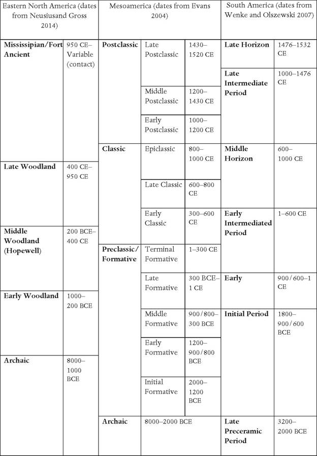
Table 20. ι A simplified comparative chronological sequence for the Americas
time leadership, craft specialization, recording systems, control of food and labor by elites, the presence of social ranking/hierarchy, dense population, long-distance exchange, and evidence of knowledge or organization that might be considered complex in terms of mathematics, religion/symbolic systems, and astronomy.[711]
The methodology and evidence we draw on is grounded in archaeology and allied disciplines including, but not limited to, radiocarbon dating, various techniques of trace element analysis and, in the limited case of the Maya, a language preserved largely in stone rather than clay, paper, or parchment.
In most cases the few written examples of Mayan and later written documents in Mexico were destroyed, and only within the last several decades have archaeologists and epigraphers succeeded in deciphering these almost lost statements. In South America, Moche ceramics were used as recording systems. In addition, with the emergence of post- processual theoretical approaches and others, including the ‘new pragmatism,' oral tradition recording systems and ethnography are increasingly being employed to frame research questions and interpret the rich record of the Americas. Evidence for complexity and exchange in North America is described first, followed by a discussion of Latin America.Subsistence and adaptation in North America
In i2oo bce, most people in North America were living an “archaic” lifestyle, with some groups engaging in experiments with horticulture. East of the Great Plains, a suite of native plants, now termed the Eastern Agricultural Complex, including goosefoot (Chenopodium berlandieri), sunflower (Helianthus annuus), squash/pumpkin (Cucurbita pepo), bottle gourd (Lagenaria siceraria), little barley (Hordeum pusillum), erect knotweed (Polygonum erectum), and marsh elder (Iva annua), were being cultivated to varying degrees. This region, centered on the Ohio and Mississippi River region, is now recognized as one of ten independent centers of food domestication in the world. By about 2ioo bce, maize was being grown in the southwestern part of North America, and by 1200 bce, other Latin American domesticates, including cotton and tobacco, were introduced. Initially grafted on to hunter-gatherer subsistence systems in both the southwest and eastern North America, these subsistence strategies form the basis for the development of very different trajectories of complexity in both regions, which are explored below. Elsewhere in North America (i.e. the Arctic, Sub-Arctic, portions of the Great Plains, California, and the northeastern Woodlands) many groups retained or modified locally distinctive hunting-and-gathering adaptations that, with the notable exceptions of the Northwest Coast of North America and southwest Florida, continued to function as diverse egalitarian huntergatherer groups until European contact.[712]
Monuments, exchange, and organization in eastern North America
Constructing mounds/earthworks (including those made of stone, shell, and earth) began during the Archaic period, perhaps 5,000 years bce.
Mound/ earthwork construction implies corporate cooperation, but not necessarily hierarchical organization. Yet, by 1200 bce, some earthworks achieved a magnitude similar to that found in much later North American groups. Early constructions such as L'Anse Amour in Labrador appear associated primarily with mortuary activity and were likely monuments associated with egalitarian mobile foragers. Between 6000 and 3100 bce, the pace of construction increased with numerous shell rings and mounds constructed in the mid-continent near the Ohio, Green, and Tennessee rivers and along the Atlantic and Gulf coasts of South Carolina, Georgia, Florida, and Louisiana. Sites with accumulated debris and middens, some of which were purposefully constructed, have been interpreted as evidence of increasing sedentism, and the development of kin-based corporate groups that may have sponsored construction to achieve status or other community recognition.[713]Unambiguous earthen mound construction begins around 4500 bce. Two sites in northeastern Louisiana, Watson Brake dating from approximately 4000 bce and Poverty Point beginning around 3600 bce, provide evidence of intentional design and planning, and, in the case of Poverty Point, the movement of extraordinary quantities of soil. At Watson Brake, construction included eleven mounds and a ridge oval that appears to have been the product of several hundred years of seasonal occupations of a most likely egalitarian local population based on the raw materials, food resources, and artifacts recovered.[714] In comparison, Poverty Point is a massive site characterized as singular and unparalleled in terms of the volume of earth moved, level of planning, and evidence for participation in far-flung raw material exchange.
Poverty Point covers an area of 7.5 km2 with a central area enclosed by six concentric ridges and five mounds. Of these, Mound A, 22 meters high with an estimated volume of almost 240,000 cubic meters of earth, is the second-largest earthwork in North America, second only to Monks Mound at Cahokia.
In addition to the massive scale of the site is the striking absence of stone, with the exception of lithic materials acquired from anywhere between 50 and 1,000 kilometers away. In addition to imported lithic materials are hundreds of thousands of clay objects, which are not seen outside of the Poverty Point “culture area.” Stone imported into the site includes an estimated 70 metric tons of exotic lithic material found in the concentric ridges, high-quality chert from the Illinois and Ohio river valleys, and steatite from southern Appalachia. It is striking, however, that no locally produced materials flow out from the site. Further, despite the volume of material and size of the site, there is no “obvious evidence of social inequality or political differentiation.” Though still highly debated, most now conclude that the social structure of residents and those associated with Poverty Point was essentially that of egalitarian hunter-gatherers who collectively constructed the site over several hundred years. Further, the site is seen not as the center of a vast integrated exchange system with outlying communities. Rather, the site is believed to be the “center of a collapsing network that draws into itself through time,” which suggests that the magnitude of Poverty Point and its material remains should persuade us to understand that complexity cannot be understood only in terms of subsistence regimes, or socio-political organization, but rather by considering the examples of more difficult to understand complexities including ritual pilgrimage, cosmology, and powerful charismatic leaders (see Map 20.ι).[715]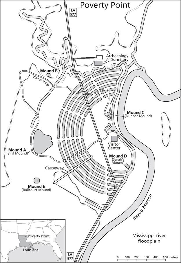
Map 20.i Poverty Point
By i2oo BCE eastern North American, Late Archaic exchange systems, Poverty Point notwithstanding, most likely functioning through the line of gift giving, were well established in eastern North America. A variety of materials were being exchanged from the Great Lakes (copper) to the Atlantic and Florida Gulf coasts, the sources of marine shell, which was exchanged northward.
In addition, a variety of other raw materials, including highly prized cherts, were exchanged locally and regionally across hundreds of kilometers. Most archaeologists have assumed that these patterns of exchange most likely intensified over the following 1,200 years, culminating in the Middle Woodland Hopewellian exchange system. However, recent work calls into question the gradualism model of change with Hopewell developing from its Early Woodland Adena counterpart. Ultimately, Hopewellian Middle Woodland communities reoccupied floodplain environments that appear to have been abandoned and engaged in the movement of a wide range of colorful raw materials from as far west as Wyoming (obsidian) and North Dakota (Knife River chalcedony) to the eastern core areas. Other materials being circulated included copper, marine and freshwater shells, freshwater pearls, mica, pipestone, silver, a variety of high-quality cherts and flint, galena, meteoric iron, and other materials. The exchange of these materials is embedded in a larger context of local and regional social, political, and religious intensification. The most dramatic regional expression is found in Ohio where extensive geometric earthworks at sites such as Newark, Hopewell, Seip, and others where large quantities of the raw materials and finished items were deposited as part of mortuary and other ritual. Recent interpretations based on the structure of sites such as Newark and analyses of mtDNA (mitochondrial DNA) remains of humans interred suggest some of these sites functioned as pilgrimage centers visited by people from outside of the Hopewell Core area in Ohio. Further work by Bolnick suggests that Illinois and Ohio Hopewell populations were interbreeding.[716]Evidence of careful design and planning of these vast centers is abundant, indicating knowledge of units of standard measurement and astronomy. Sites in the Hopewell core area of Ohio were carefully planned and engineered, utilizing a variety of intentionally selected soils to create sacred spaces and mortuary facilities associated with them.
The most spectacular of these is Newark Earthworks, arguably the largest earthwork complex in the world. Newark includes the Great Circle, almost 400 meters in diameter, the Octagon Earthworks and associated circle which together enclose an area of approximately 28 hectares, the Wright Earthworks, and a series of causeways that connect the portions of the site and link it to other Hopewell sites to the south (see Map 20.2).[717]Artifacts associated with Hopewell/ian sites were manufactured out of various raw materials and no doubt conveyed a variety of meanings (social, religious, and political) which, combined with earthwork construction, reflect a cosmology that is thought to represent historically deep belief and mythology such as the Algonkian earth diver creation story. Elsewhere in the Hopewellian world (Illinois, Great Lakes, the lower Mississippi valley, and other locations), most sites lacked the geometric earthworks, but mound construction followed principles associated with the Hopewell worldview. Artifacts interred in the mounds display additional linkages to the Hopewellian worldview through the types of raw materials, artifact style, and form.[718]
Despite the extensive networks of exchange and the construction of large and complex geometric earthworks in the core, Hopewell socio-political organization was most likely characterized by a series of local egalitarian band or tribal communities, including camps and villages with associated mortuary facilities, integrated into larger networks of kin and economic exchange. These larger integrative communities, occupying somewhat larger regions, were ultimately integrated into symbolic communities with shared cosmology, including shared iconography in ceramic style, raw material, and finished artifacts and in some cases shared mortuary practices. The largest and most spectacular of the sites in Ohio can be thought of as paramount integrative communities supported by both local communities and more
loaded from https:Zwww.cambridge.org/core. Cornell University, on 07 Jan 2017 at 22:34:32, subject to the Cambridge Core term
∣ble at https:Zwww.cambridge.org/core/terms. http://dx.doi.org/10.1017/CB09781139059251.022
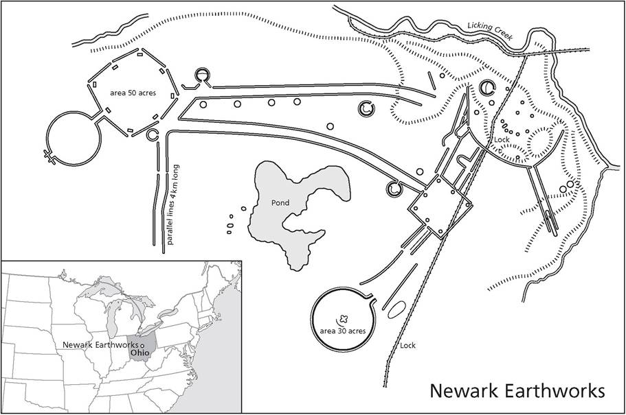
Map 20.2 Newark Earthworks
far-flung groups who shared beliefs about the organization of the cosmos and interacted with regard to ritual, material, and kin exchange in multiple
II ways.
Absent the fine/r scale chronologies we have today, the disappearance of Hopewell/ian communities around 400 ce was initially characterized as a collapse, but is now seen as a gradual disappearance of the ritual, geometric earth construction, and exchange networks. Local Hopewell/ian communities began to modify as new kinship patterns were established, replacing ritual, social, and economic relationships. Subsistence practices involving the introduction of new cultigens, including maize, intensified in some places, and regional variation intensified mound building while exchange of some kinds of raw materials and finished objects, albeit on a much reduced and transformed manner, continued in the Late Woodland period across the eastern United States.[719] [720]
Once referred to as the good “gray cultures” between the Hopewell and Mississippian zeniths, the Late Woodland period (c. 400-950 ce) in the mid-south and southeast North America is now understood to be the one during which the emergence of politically complex, hierarchical, urban societies associated with the Mississippian period occurs. During this period, maize agriculture became dominant, and mound construction continued and eventually regularly incorporated platform mounds. Platform mounds occurred occasionally in Middle (for example Pinson Mounds in Tennessee) and early Late Woodland contexts before 800 ce. After 800 ce, platform mounds became common on sites and signal substantive changes in social organization and political complexity. Sites indicative of this change include Troyville in Louisiana and Toltec in Arkansas among others. The central and lower Mississippi valleys during the Late Woodland period thus provide evidence for the realignment of society and monument building where communities are no longer tied together through kin, or symbolic and exchange ties. Rather, by 900 ce in this region of North America, transformation of the landscape through monumental building indicates that the stage was set for the communities where hierarchical corporate groups emerged along with evidence for political alliances, warfare, and urbanism characteristic of the Mississippian period beginning around 950 ce in the American Bottom.[721]
Emergent complexity and exchange systems in the North American southwest
At 1200 bce, the North American Southwest, like other regions of the continent, was characterized by relatively small-scale “archaic” societies. However, unlike other areas of North America, by this time most groups in the southwest were familiar with maize and squash, which were introduced from Mesoamerica perhaps before 2100 bce. The introduction of maize from Mesoamerica was but the first step of long and continuous interaction and exchange between the American Southwest and Mesoamerica.
Maize and squash were initially grafted on to subsistence strategies characterized by gathering plants supplemented by hunting by egalitarian groups whose populations had begun to grow and who were experiencing reduced mobility. By the end of the Archaic period, some time around 200 bce, groups were still somewhat mobile, but moving less frequently. Unlike in the Middle East, where sedentism appears to have preceded domestication, the first farmers in southwestern North America retained their mobile settlement strategies until some time after the second century ce when the material remains and architecture of sites suggest the development of village occupation throughout the year. Villages were characterized by semi-subterranean pithouse construction. Between 200 and 500 ce, the first ritual structures suggestive of larger corporate group activity known as kivas appear. By 500 ce there is evidence of population increase throughout the region, and in two areas in particular: the Sonoran Desert region of southern Arizona and the Four Corners region (the intersections of southwestern Colorado, southeastern Utah, northeastern Arizona, and northwestern New Mexico).[722]
Beginning around 500 ce in the Tucson and Phoenix region of Arizona, pithouse structure clusters are organized around plazas with adjacent ceremonial structures. These sites are associated with the archaeological Hohokam groups who by 500 ce were constructing irrigation canals which, between 1100 and 1450 ce, provided water for between 20,000 and 40,000 hectares ofland watered by over 600 to 800 kilometers of canals, supporting a population of perhaps between 20,000 and 100,000 people. Between 700 and 1150 C e, other attributes including communities organized around central plazas, Mesoamerican-derived earthen ball courts, craft production of ritual and other objects and iconography appear in the Hohokam region. Perhaps the best known of Hohokam sites is Snaketown, situated strategically near the intersection of the Salt and Gila rivers, a position to control exchange between the two major drainages in the southern southwest region. Exchange within the Hohokam region, including the Mimbres area of southern New Mexico, increased along with increased exchange with western Mexico for marine shell, copper, and other materials. However, little evidence exists of hierarchical ranking during the period of time before 1150 ce, making it difficult to understand the social and political dimensions of Hohokam society. The Hohokam never achieved the kind of complexity characterized by state-level societies to the south and represents an unusual example of a “middle range irrigation society.”15
Beginning around 500 ce in the Four Corners, Colorado Plateau region, some pithouse community residents begin excavating larger circular structures, which are thought by archaeologists to be ceremonial kiva structures, although the exact nature of their ritual function is not well understood for this time period. By the late eighth century ce, semi-sedentary pithouse communities give way to large aggregated villages characteristic of the Ancestral Pueblo. Villages are constructed above ground, but residential mobility remains high with abandonment of villages and valleys and the dispersal to different regions of the plateau by 900 ce. The significant exception to this is Chaco Canyon in the San Juan Basin of northwestern New Mexico. Here, by 850 ce, a series of “great houses,” pueblo communities characterized by numerous rooms and kivas, including one “great kiva,”
Inequality and Religious Transformations,” in Pauketat (ed.), Oxford Handbook, pp. 54760; and Lisa Young, “Diversity in First-Millennium ad Southwestern Farming Communities,” in Pauketat (ed.), Oxford Handbook, pp. 561-70.
15 Suzanna K. Fish and Paul R. Fish, “Hohokam Society and Water Management,” in Pauketat (ed.), Oxford Handbook, p. 570; Plog, Ancient Peoples, p. 113; and Mills, “The Archaeology of the Greater Southwest,” pp. 547-60. were constructed at Pueblo Bonito, Una Vida, and Penasco Blanco. Astronomical and cardinal directions governed the orientation of these and subsequent communities, and eventually they were linked to each other through a system of roads constructed across the landscape, crosscutting landforms with the intention of following a cardinal or astronomical direction. Eventually, Chaco emerged as a region controlled by powerful elites who manipulated the exchange of turquoise over 2,000 kilometers to Mesoamerica and the distribution of Mesoamerican goods including marine shell, scarlet macaw bird feathers, and copper to other regions of southwestern North America. The power and control in evidence at Chaco are demonstrated by high-status burials with retainers, great houses, and the regional control exerted by Chaco in the period following 900 ce.[723]
Only within the last fifteen years or so have archaeologists working in southwest North America seriously considered the evidence for elites and hierarchy in many areas of the region including the Hohokam, Chaco, and Casas Grandes and the implications of that evidence for understanding issues of power, authority, and complexity. Most now recognize that these were not egalitarian societies, but societies where power may have been derived from a variety of socio-political, religious, or economic strategies employed by elites. In any case, a more thorough discussion of emergent complexity, power, and exchange in the North American Southwest occurs in a time frame beyond the scope of this chapter.[724]
We now turn to consideration of the development of complex sociopolitical phenomena and exchange systems in the southern half of the Americas. While there remains a high degree of uncertainty about the classification of complex societies present in North America into official “state”-level civilizations, the states and complex civilizations that emerged in ancient Mesoamerica are far less ambiguous. Beginning with the Olmec and nascent Zapotec states during the Formative/Preclassic period, there is a successive progression of state rise and collapse in the region until the arrival of Europeans in the fifteenth century. During this time, a number of complex state-level civilizations emerged, both independently and as a result of complicated interregional interactions which, at times, spanned the length and breadth of much of Mexico and northern Central America.
Mesoamerica
While a detailed analysis of state formation is beyond the scope of this chapter, we have sought to provide here a brief overview of the major developments of the Mesoamerican peoples during the time periods ranging from the emergence of complexity in the Preclassic/Formative (~3,500 bce - 100 bce) through the collapse of the subsequent Classic period civilizations between 650-900 ce. It is during these periods that some of the most intriguing changes and developments in the region occurred, setting the stage for the eventual rise of complex empires, such as those of the Mexica of the Central Highlands and the Tarascans of Michoacan.
Mesoamerican society revolved around the growth and consumption of three primary crops: maize (Zea mays), beans (e.g. Phaseolus vulgaris), and squash (Cucurbit sp.) These three plant crops support one another and can be grown in close proximity in addition to providing all of the essential vitamins and nutrients needed for human survival. Maize, in particular, played a vital role in the development and expansion of Mesoamerican civilizations.
The Mesoamerican Preclassic: interregional trade and emergent complexity
Mesoamericanists define the Preclassic as the period of complexity that followed the emergence of permanent settlements and agricultural practices, but preceded the large-scale states of the Classic period. It is during this time that the early emergence of complex, state-like societies can be first identified. While it was once believed that the Olmec culture of the Gulf Coast region served as a primogenitor for much of the subsequent complexity and cultural development throughout Mesoamerica, more recent work in the Valley of Oaxaca has given rise to evidence that supports a much broader development of complexity, which is likely the result of interregional trade networks and intercultural relations that spurred growth in both the Olmec region and that of the Zapotecs of Oaxaca.
The Olmec: the origin of Mesoamerican cultural practices
The Olmec are perhaps best recognized for their stone head monuments, which have been discovered at most of their major ceremonial centers in the Gulf Coast region. These monuments, which are made from single, massive blocks of basalt that were transported great distances, seem to represent important figures, possibly chiefs or leaders, who may have presided over the sites. They serve as clear evidence for the presence of elites with the ability to organize and control the movement of such a resource over great distances.
According to many Mesoamericanists, the Olmec represent one of the first recognizable cultural horizons to emerge in the region. Although their classification as a full-fledged, state-level civilization is controversial, the lasting impact the Olmec culture appears to have had on the later societies and civilizations in the region is undeniable. These impacts are visible in many aspects of pan-Mesoamerican life-ways and culture and have led many to see the Olmec as a “Mother Culture” phenomenon in the region. Conversely, there are those who see the Olmec has having had a lesser impact on other Mesoamerican societies and consider it to be more of a “Sister Culture” to the other Preclassic cultures of Mesoamerica.[725]
Despite this debate, which often centers on the emergence and presence of a widespread Olmec art style, the Olmec were an influential presence in the Preclassic Mesoamerican landscape in a number of key ways. These include the foundations of the first interregional trade networks, the first appearance of the Mesoamerican calendar system, early evidence for pan-Mesoamerican deities/ figures and bloodletting rituals, and the origins of the Mesoamerican ball game. All of these are seen as clear evidence for increased social complexity in the region and, indeed, may have served to spur many other parts of Mesoamerica toward increasing complexity or been the result of the Olmec's interactions with these other regions.
While the foundations and early period of Olmec presence in the region pre-dates 1200 bce by about 1500 years, the height of the Olmec civilization seems to range from 1400-400 bce. During this period we see a shifting of power within the Veracruz region among a series of powerful ceremonial centers which seem to have successively dominated the region. The earliest of these regional powers was the site of San Lorenzo.
Located on the Rio Chiquito, the site of San Lorenzo reached its peak from 1200-900 bce and serves as the first major Olmec cultural horizon within the regional sequence. Built on a hilltop, San Lorenzo represents the first significant administrative center in Mexico. In addition to at least ten colossal Olmec Heads, the site was dominated by several monumental structures that appear to have been built specifically for ceremonial or administrative purposes. Both serve as clear evidence for a socially stratified society. The reason for San Lorenzo's decline remains ambiguous, but by 900 bce, power and populations had shifted away from the site.[726]
La Venta, located on the Tonala River in the southeastern part of the Olmec Heartland (that area with the most direct Olmec evidence and influence) rose to dominance following the decline at San Lorenzo. This site dominated the area from around 900-400 bce and offers an interesting view into the ritual lives of the Olmec people.
Valley of Oaxaca: trade networks and martial power
The earliest evidence for extensive trade networks and the role they played in early state development in Mesoamerica can be seen in the interregional interactions between the Olmec Heartland of the Gulf Coast and the nascent Zapotec state forming in the Valley of Oaxaca during the Preclassic period. While there is debate over whether these Preclassic period societies achieved true statehood, it is understood that it was through control over long-distance trade networks linking the Gulf Coast and Oaxaca that both regions emerged as key players of the Preclassic Mesoamerican landscape.
At this time, trade between the regions seemed to revolve around the movement of raw goods, such as shell and feathers, out of the Olmec region to the Valley of Oaxaca (see below), with finished products and some raw materials from the Valley of Oaxaca returning to the Gulf Coast. One trade good that seemed highly prized in the Olmec Heartland came in the form of small iron-ore “mirrors” that are commonly found in elite Olmec contexts and have their production and origins in the Valley of Oaxaca. Through this trade network, the Olmec elites had access to prestige goods from Oaxaca, which, in exchange, benefited from the prestige of being able to trade with the Olmec.[727]
In the Valley of Oaxaca, we see clear evidence for increasing cultural complexity during the Preclassic/Formative period. While it was originally believed that this complexity resulted from the trade relations the people of Oaxaca had with their Olmec neighbors, it now seems likely that both cultures emerged independently of one another, but influenced each other through such interactions.
The site of SanJose Mogote has yielded some of the best evidence for the presence of a strong, martial elite. Located in the northern arm of the Valley of Oaxaca, SanJose Mogote served as one of the more powerful sites during the Preclassic period. Evidence at the site in the form of figures carved into blocks of basalt stone, known collectively as the Danzantes, suggests that conflict and martial power were both commonplace and intensifying at this time. The figures themselves, once believed to be ritual dancers, seem to actually depict dismembered and mutilated captives. Many of them contain early forms of the Zapotec blood glyph, lending credence to this interpretation along with pushing back evidence for non-Olmec writing systems during this period.
Central Mexico: the origins of Teotihuacan
During the Late Formative/Preclassic period (400 bce - 100 ce), the Basin of Mexico saw the emergence of two major sites that vied for control over the region. During this period, Teotihuacan controlled the northern part of the Basin of Mexico through access to the key obsidian sources in the region (Sierra de las Navajas/Pachuca and the Otumba source). Meanwhile, Cuicuilco, located in the southern part of the Basin of Mexico, rose to power because it controlled the trade routes in and out of the southern part of the region. This control over the southern part of the Basin of Mexico lasted until the Tzacualli phase (100-200 ce) when Cuicuilco began to decline due, at least in part, to the growing economic power of Teotihuacan. This decline continued until Cuicuilco was eventually destroyed by a volcanic eruption, at which point the population center of the Basin shifted northeast to the Teotihuacan Valley. By 250-300 ce, Teotihuacan dominated the Basin of Mexico and controlled trade of obsidian from the Basin of Mexico sources via routes throughout the greater Mesoamerican region, ranging as far away as highland Guatemala.[728]
By the end of the Preclassic period at Teotihuacan, there is evidence of a systematic consolidation of population into the urban center. The leadership of the city (whose identity is still unknown) seems to have ordered the razing of those buildings that were previously present and had the city rebuilt on its present orientation, along with many of the other major structures found in the core of the city. Cowgill further suggests that the nature of the building projects at this time suggests the tantalizing possibility of the presence of what he describes as “a strong, very skilled, ambitious, and probably charismatic person with good rhetorical skills” who may have taken over leadership of the political structure of the city. While some of the evidence suggests the presence of such a leader, it is hardly conclusive. Current work by Sergio Gomez seeks to discover the tombs of these early leaders under the Temple of Quetzalcoatl in the Ciudadela region of the city. Following this realignment of the city, the majority of the populace moved into apartment compounds within the city, which were built along the city's grid pattern. This pattern of occupation continued through the remainder of the Teotihuacan sequence until the city's eventual collapse and subsequent depopulation around the year 650 ce.[729]
The Classic period: urban centers and long-distance trade networks
The Classic period (100-900 ce) of the Mesoamerican cultural sequence delineates a time of increasing complexity and widespread cultural interactions between vastly different groups of people. It is during this time when the widespread nature of long-distance trading networks comes to the fore as a source of power and success within the broader Mesoamerican context. During this period, we see the first evidence for urbanization in the Basin of Mexico with the city of Teotihuacan emerging as the first and largest urban center in the Americas at the time. Along with many of these economic changes, we see the emergence of large, complex states throughout the region.
The cultural and political landscape of the Classic period is rife with complex interactions that span vast distances, unaided by large domesticated animals as a source of labor or transportation. Trade between the major civilizations at this time spurred growth in many of the regions where statelevel development came to pass. Chief among these were Teotihuacan in the Basin of Mexico, the Classic Maya polities of Belize, Honduras, Guatemala, and the Peten region of Mexico, as well as the Zapotec city of Monte Alban in Oaxaca, Mexico.
Central Mexico: Teotihuacan
The true extent of Teotihuacan's influence and presence throughout the region is still not fully understood, but it is likely that the city had a much wider impact than presently believed. While this presence and influence does appear to be widespread throughout Mesoamerica, it seems to be of an economic nature, rather than one of conquest. Indeed, much of the power held by the city of Teotihuacan was based on the continued control the city had over a key source of green obsidian found at the Sierra de Navajas, commonly known as the Pachuca obsidian source, in Hidalgo, Mexico. While obsidian is found throughout much of the Greater Mesoamerica region, the obsidian from the Pachuca source was prized for both its high quality and its green-gold color. Obsidian from this source has been found as far away as Guatemala to the south and Oklahoma to the north. This obsidian was the foundation for much of the Classic period long-distance trade for which Teotihuacan seems to have been a central hub.[730]
At its peak, Teotihuacan actively controlled trade in the Basin of Mexico and had spread its long-distance trade networks throughout the greater Mesoamerica region. These trade networks supported a Teotihuacan presence in Oaxaca, the Gulf Coast, and the Maya region, with many of these regions having an active presence at Teotihuacan in return. Interactions between the Zapotecs of Oaxaca and the Maya of both the Gulf Coast and Highland Maya region were complex and are still not fully understood. Contact, likely through trade, is also in evidence in Michoacan, West Mexico, and northward into Chihuahua.
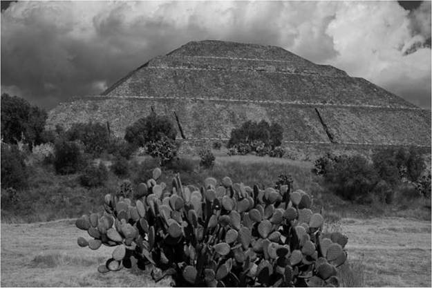
Figure 20.1 Temple of the Sun, Teotihuacan, Pyramid, Mexico, over 70 meters high, world's largest pyramid, Aztec temple built 100 ce (Tom Till / Alamy)
At its peak, it is estimated that 125,000-150,000 people lived within the 20 km2 city. In addition to the apartment compounds, Teotihuacan contained hundreds of ceremonial buildings, with a high concentration of public and monumental architecture located along the major north-south axis of the city, known in modern times as the Street of the Dead. It is along this north-south axis of the city that many of the major architectural structures of Teotihuacan were built. These include the early ceremonial center known as the Ciudadela (located at the southern end of the 2.2 kilometer Street of the Dead), the Pyramid of the Sun, and the Pyramid of the Moon with its associated temple and palace complexes. The Pyramid of the Sun represents one of the most elaborate building events at Teotihuacan. Containing an estimated 1.76 million cubic meters of soil, this rubble-filled structure is one of the largest preindustrial engineering feats in the Americas (see Fig. 20.1).[731]
Unfortunately, the political structure of Teotihuacan is not easy to determine due, in part, to the absence of royal tombs within the city. Recent work by Mexican archaeologist Sergio Gomez has attempted to locate potential royal tombs under the major temple structure within the Ciudadela complex, but the results of these explorations are still incomplete. While no royal tombs have been reported, there is a clear elite presence within the city, with proximity to the central core being a marker of social, and presumably economic, standing within the city. The Teotihuacan state seems to have at least partially controlled the settlement patterns within the city, establishing a complex and rigid grid pattern, which is oriented on an axis set 15.50 east of true north. Those apartment complexes that are closer to the core show higher degrees of internal decoration (murals) and increased prestige goods in burial contexts. The source of wealth for many of the elites was through long-distance trade and state control over the production of goods within the city.
While no evidence of ball courts at Teotihuacan exists, there is some limited indication that the people of Teotihuacan had adopted the basic 260-day Mesoamerican calendar system. In addition, a limited glyphic system exists, which has not been fully deciphered. Further evidence, found at Monte Alban and in parts of the Maya region, suggests an iconic manner in which the people of Teotihuacan were being depicted by their neighbors, including the use of butterfly imagery and the depiction of atlatl-like spear throwers. It is through these faraway images that the presence of Teotihuacan in these regions has had its strongest support. Research has suggested that there may have been marriage ties between people of Teotihuacan affiliation and some of the ruling dynasties of Monte Alban (Zapotec) and Copan (Maya).25
Highland Maya: the city-states of Central America
The Classic Maya civilization rose to power between 300 and 900 ce in the southern highlands of Mexico's Peten region, Belize, Honduras, and Guatemala. Unlike Teotihuacan, which was a centralized city-state with
and Emily McClung de Tapia and Luis Barba Pingarron, “Ciencias aplicadas al studio de estructuras monumentales en Teotihuacan, Mexico,” accessed February 25, 2014, www.saa.org/Portals/0/SAA/Publications/amantiq/articleMcLung.pdf (2011).
25 Cowgill, “State and Society,” 143; Titiana Proskouriakoff, Maya History (Austin: University of Texas Press, 1993); Clemency Coggins, “The Age of Teotihuacan and Its Mission Abroad,” in Kathleen Berrin and Ester Pasztory (eds.), Teotihuacan: City of the Gods (New York: Thames and Hudson, 1995), pp. 140-55; and Evans, Ancient Mexico and Central America. limited evidence for a clearly defined leader, the Classic Maya civilization comprised many sovereign city-states (and their hinterlands) which were connected through a complex network of political conquest and alliance led by divine kings. The power and lives of these high-ranking elites are clearly outlined and recorded on carved stone monuments, known as stelae. These monuments, carved by master craftspeople, were created at the behest of the ruling elite as a means of propaganda as the elite class sought to immortalize conquest, alliance, marriage, and many other details of their lives in stone. Furthermore, given the durability of these monuments, they survived the passage of time and the Spanish missionaries' textual purges of the sixteenth and seventeenth centuries. As such, it is through these monuments that much of the textual evidence for the Classic Maya civilization has been gleaned.
While it was once believed that the Classic period Maya civilization was a peaceful society dominated by an intellectual class of scholars, philosophers, and mathematicians, modern views of the Classic period Maya people paint a very different picture. The Maya civilization was rife with complex political interactions between the various city-states, with royal leaders engaging in a complicated dance of political alliance, warfare, ritual, and death. City-states were organized around advanced ceremonial centers with a low degree of urbanization. Occupants of these centers were usually members of the ruling elite class and their immediate retainers and support networks. The overwhelming majority of the Maya populace lived in small, rural villages, which in turn served and supported the local elites living at these centers. The ceremonial centers are dominated by massive public and ceremonial architecture in the form of temples, pyramids, and palaces where the ruling class lived and worked. Rulers of these city-states established themselves as divine leaders, inextricably linking those who ruled to the complicated world of the Maya cosmology through blood sacrifice and complex ritual guided by a complex calendar system.
Mesoamerican calendar systems
While the Mesoamerican calendric system can be traced to the Olmec, it is the later adaptations and uses of this system that are best known. The Mesoamerican people possessed a detailed and intricate calendric system comprising two interconnected calendar cycles. The first of these calendars, called the Ha'ab by the Maya, is regarded as a solar calendar due to its 365-day count. These days are sorted into twenty-day months, of which there are eighteen, with five “unlucky” days, known as the Wayeb, accounting for the
Table 20.2 Chart showing the units of the Maya Long Count calendar system
| Days | Unit | Long Count unit |
| I | 1 K’in | 1 K’in |
| 20 | 20 K’in | 1 Winal |
| 360 | 18 Winal | 1 Tun |
| 7,200 | 20 Tun | 1 K’atun |
| 144,000 | 20 K’atun | 1 B’ak’tun |
annual cycle. The second calendar, referred to as the Tzolk'in by the Maya, measures a 260-day cycle. These days are split into twenty “months” consisting of only thirteen days each. When the calendars are viewed together, they provide a unique day designation based on the cycle of interlocking points that repeat once every fifty-two years, known collectively as the Calendar Round.
While the fifty-two-year cycle served for most of the ancient civilizations of Mexico, the Maya sought to expand their record of time beyond this. To this effect, they created what is known as the Long Count Calendar (see Table 20.2). While the Long Count system was based upon the cycle of the Calendar round, it expanded the divisions of time beyond the fifty-two-year cycle by creating new divisions for the segmenting of time. Grounded in the Maya base-twenty counting system, days were bundled into groupings of twenty that could be counted both forward and backward, allowing the Maya an unlimited record of the passage of time. This was due, in part, to their use of a “null” equivalent to the modern concept of “zero,” which served as a place holder in the long count date system.
The Classic period collapse
Starting between c. 600 and 650 ce, problems and instability began to emerge in the Basin of Mexico. It is believed that this instability was a feedback result of Teotihuacan’s monopoly over Pachuca obsidian. As trade networks expanded, costs for procurement of the green-gold obsidian at the far reaches of Teotihuacan’s networks caused people to seek out other sources of green obsidian, which were relatively cheaper to utilize. As a result, new sources of green obsidian were sought, including sources in the Maya region and Michoacan, and Teotihuacan’s monopolistic control over the obsidian trade was shattered. This in turn resulted in a collapse of the Teotihuacan trade system, which served to destabilize the state as a whole.
Around 650 ce, this instability resulted in the downfall of Teotihuacan. As trade routes shrank, the lower-ranked elites of the city suffered cutbacks and losses not felt by the upper elites. As a result of growing unrest among their ranks, the lower elites rose up and destroyed much of the core of the city through selective burning of the temples and major palaces along the Street of the Dead. Following this, the core of the city was abandoned and never reoccupied, although occupation of the outskirts of the city has never ceased.
Until recently, the complexity of the Maya collapse was not fully understood. It is now believed that the “collapse” of the Classic Maya civilization was less a single event, and more a series of small-scale, regional collapses, which created a domino effect that served to destabilize the entire region until the civilization ceased to function at the state level anymore. Among the major causes for these collapses were famine and political unrest resulting from drought, environmental destruction, intensification of warfare between rival city-states, and population pressures from the collapse of Teotihuacan. Combined, these factors served to bring the Classic Maya civilization to its knees.
Coe points out that between 790 and 830 ce, Maya cities were failing at an alarming rate. By 889 ce, he reports the number of sites recording the ending date of the 10.2.0.0.0 k'atun had fallen to five. January 15, 910 ce, found on a monument at the site of Itzimte, represents the last recorded date at any of the Classic Maya sites. While the populations and power in the Maya region shifted north into the Yucatan, Maya civilization as a whole never reached the social, political, or innovative heights experienced in the highlands states of the Classic period.[732]
The regional collapses at the end of the Classic period ultimately paved the way for a series of powerful states to rise and fall throughout the Greater Mesoamerica region. The Toltecs set up a small state near Teotihuacan, in the Tula region, which sought to capture some of the previous city's glory. The fall of the Toltec state around 1200 ce, in turn, gave way to the eventual emergence of the notorious Aztec Empire in the fourteenth century ce.[733]
South America
It is difficult to classify the entire continent of South America as one region. Like North America during Pre-contact times, South America was home to a wide variety of cultures and peoples. Of these, very few show clear evidence for state development. This region is best known for the development of the Inca Empire during the Late Horizon period (1476-1432 ce).[734] However, this empire represents only the last of the complex societies that emerged in the Andean region. While the early period of development for this region is not as well understood, evidence for early complexity seems to date to sometime around 3000 bce with the emergence of stratification at sites such as Kotosh in the highlands, along with Caral and El Paraiso, among others, in the coastal region. These sites established the precedence for the flourishing and increasing complexity that, ultimately, gave rise to the Inca state following the collapse of the Tiwaunaku and Huari states at the end of the Middle Horizon (600-1000 ce).
Formative period (3200-900/600 bce)
The first clear evidence for the initial rise in socio-political complexity in South America seems to come from the coastal regions of Ecuador and Peru. It is believed that populations in these regions were supported by extensive marine resources, which were supplemented by a shift to agrarian practices with the appearance of maize agriculture sometime between 5000 and 1500 bce. This early shift to sedentary communities and the increasing resources available to the populations of the coastal region ultimately resulted in the development of monumental architecture during the Formative period (3200-900/600 bce). This is often split into a Preceramic (3200-2000 bce) period and the Initial period (1800-900/600 bce).[735]
Preceramic development
Much of the discussion regarding complexity in the Preceramic period revolves around the presence of public and monumental architecture, which predates the appearance of ceramic technology in the region. The Andean region is interesting in that extensive monumental architectural undertakings pre-date the appearance of ceramic traditions. By 3000 bce, a number of coastal Andean sites show evidence for public architecture in the form of mounds and “temple” structures. These buildings, often in the form of terraced platforms, represent communal ritual space and a high degree of social organization of labor. One of these early sites with public and monumental architecture is the Peruvian site of Caral, which has been dated to between 2627 and 2020.[736]
In addition, there is evidence for social stratification in housing and burial ritual that dates to this early period. Two of the key sites from this region are the coastal site of El Paraiso and the highland site of Kotosh. El Paraiso has been cited as the oldest evidence for such architecture in the region, despite the recent destruction of one of the pyramid mounds by construction companies. Both sites hold clues to a widespread cultural complex that guided the building and orientation of such structures, along with tantalizing evidence for ritual activity (especially at the site of Kotosh in the highlands). It has been suggested that the major function of the architectural monuments of the Late Preceramic period may have revolved around communal ritual enactment. Much of this architecture included open areas, such as plazas, in which community gatherings and activities could have occurred.[737]
Long-distance trade played an important role in the various societies of the Preceramic period. Trade networks stretched up and down the coast of Peru and Ecuador, in addition to those that linked the coastal region to the highland. Obsidian and other raw materials seem to have moved from the highlands into the coastal region, along with some highland domesticates, such as potatoes. In return, the coastal region sent marine shells, fish, and other maritime resources into the highlands. Burger also notes that salt may have served as an important trade item for the people of the coastal regions, with evidence suggesting that the production of salt may have occurred during the Late Preceramic period.[738]
Burger also points out that there is limited evidence for craft specialization during the Late Preceramic period, nor is there overwhelming evidence for clear markers of social status objects (such as earplugs, which become important markers of male status in later times). However, there is evidence for a complex textile industry. These textiles were usually made from cotton fibers through a weaving process called twining rather than through the use of warp and weft weaving. These textiles often depict motifs and imagery that represent precursors to the later motifs of the Chavin culture, strengthening the evidence for long-term cultural continuity in the region.[739]
The Norte Chico culture
According to Haas and Creamer, the Norte Chico region of the Supe valley shows the earliest evidence for a dramatic shift in cultural and social complexity. During what they refer to as the Late Archaic period (3100-2900 b c e), this region experienced a significant shift in social patterns, which ultimately gave rise to the earliest evidence for public architecture.[740]
El Paraiso shows some of the earliest evidence for public, monumental architecture in the Andean region. Architecture at this site includes rectangular earthen mounds that have an orientation of 25° east of north. These mound structures serve as precursors to many of the Chavin U-shaped temples and mounds from the Initial phase. Indeed, the site of Chavin de Huantar itself possesses these early mounds suggesting a high degree of site, and likely cultural, continuity between these early settlements and the emergence of increasingly complex settlements during later times.[741] [742]
While the coastal regions of Ecuador and Peru were supported by the bounty of the Pacific Ocean with supplemental agricultural practices eventually emerging, the highland region depended on domestication as early as 5000 bce. By 3000 bce, it is believed that the majority of important domesticates used by the people of the highlands were available. Among these domesticates were maize (which was more suited to the valley floors), potatoes, oca, ullucu, quinoa, guinea pigs, and native camelids.36
The first clear evidence for architectural development in the highlands was found at the site of Kotosh. Other highland sites have been subsequently discovered. These sites all consist of similar architecture and site layout. The general plan for these sites includes “free-standing buildings with central stone-lined firepits,” which have either a rectangular floor plan with rounded corners or are round and were used for community ritual purposes involving the burning of offerings in the building's chambers. This regionally practiced religious complex combining sacred architecture with ritual enactment has been referred to as the Kotosh Religious Tradition. Burger points out that there are differences in the construction of these ceremonial buildings, but likens them to the Kiva complexes of the North American Southwest in that, while the exact dimensions, materials, and placements of the structures vary between sites, the ritual and social significance did not.[743]
Initial period
Around 2000 bce, pottery and ceramic technology appeared in the Peruvian coastal and highland regions. Archaeological evidence suggests that ceramic technology had been present in parts of Ecuador for nearly a millennium at this point. It is unclear, however, as to why it had not been adopted by the Peruvian societies, despite evidence for trade networks and other points of contact between the regions during the Peruvian Preceramic period. With this shift to ceramic technology, and possibly as a point of explanation for the appearance of ceramics, the coastal societies of Peru seem to have shifted away from maritime resources to a heavier reliance on agrarian production around the same time.[744]
There was a dramatic increase in the complexity of public architecture in the coastal region at this time. Burger notes a number of sites where U-shaped pyramid mounds appeared. This monument complex is made up of terraced platform mounds that make up three sides of a plaza. While the middle mound is usually the largest, there seems to be little consistency in the sizes of the flanking mound or between sites. What is consistent is the openness of the fourth side of the plaza, which faces the middle mound, in addition to the open space between at least one of the flanking mounds and the central mound. These mound complexes are usually oriented to “between 13° and 64° east of true north.”[745]
Chavin: the first Andean state?
The first clear evidence for a widespread state presence in the Andean region can be found at the site of Chavin de Huantar. This site, which has its origins in the Preceramic period, rose to dominance between around 800 and 500 bce.[746] Archaeological evidence suggests that Chavin de Huantar started as a ceremonial center before emerging as the core of a nascent state during the Initial period. Evidence for the widespread Chavin presence is most clearly demonstrated through regional presence of artistic styles including complex iconography that has been interpreted as representing a widespread belief system. Among the characteristic iconography is that of a humanoid jaguar figure which appears throughout the region, both in stone and on finely crafted prestige goods, such as textiles and gold.[747]
The site itself comprises a central, U-shaped plaza with associated religious buildings in the form of flat-topped pyramid structures. It is the presence of these pyramids that has served as a connection between the culture of Chavin de Huantar and the Preceramic period to which many of the early ones have been dated. As the site rose in importance, there was extensive building and expansion of the ceremonial core of the site, and the site itself shifted from ceremonial in nature to being occupied by a wider population.
Evidence suggests that instability during the Early Horizon period, between 400-200 bce, resulted in the decline of both the site of Chavin de Huantar and the larger Chavin region.
First Horizon: Moche
Following the dissolution of the Chavin Horizon (c. 250 bce), a number of small, regional states emerged throughout the Andean region. Many of these were situated along the small river valleys dotting the coastline. Among these were the Moche and the Nazca cultures, the latter being made famous by their linear and zoomorphic designs in the desert. Evidence during this period clearly shows a high degree of socio-political complexity, particularly among the Moche. Despite this, there is some disagreement as to whether the Moche civilization represents an aggressive, expansionary chiefdom or a true state.[748] Despite a lack of written records, the Moche culture of the First Horizon period (200 bce - 600 ce) is among the best understood of the early statelevel civilizations in the region. This is, to a great extent, due to the detailed record of Moche life represented on Moche ceramics, which are famous - perhaps infamous - for their detailed depictions of almost all aspects of life in Moche times, including hunting, warfare, weaving, and sexuality. As a result of this pictographic record system, much is known about life in Moche culture that is unknown for similar societies. It is from this pottery record that archaeologists have been able to decipher important ritual elements from Moche society, such as the “Sacrifice Ceremony” in which an important figure is depicted receiving a chalice from a subordinate figure and is often accompanied by depictions of human sacrifice ritual.[749]
As with other coastal societies, the Moche civilization relied heavily on the natural marine resources provided by the Pacific Ocean. In addition, agricultural innovations allowed the people of the Moche region to successfully farm what small amounts of irrigable land they could. This, in turn, supported a growing population.
The discovery of Sipan in 1987 shifted the debate over the classification of the Moche culture. Prior to this, the Moche were seen by many as a complex chiefdom with a highly aggressive expansionary policy. The Royal Tombs of Sipan have been used to suggest that a much higher level of power may have been held by the Mochica rulers, demonstrated through the extensive grave goods (including precious metals such as gold) and the inclusion of human sacrifices in the tombs.[750]
Non-Andean complexity
Much of the discussion of complexity in South America revolves around the development of complex states in the Andean region. While it is true that early state formation first appears in this region, it is by no means the only region of the continent where complexity emerged. While no other state-level development occurred in South America, work throughout the Amazonian region has revealed complex chiefdom-level societies. Evidence for mound building is reported at a number of sites, including “Llanos de Mojos in the Bolivian Amazon, the uplands of the Ecuadorian Amazon, Marajo Island at the Mouth of the Amazon, the coastal plain of the Guianas, and the Middle Orinoco.” Mounds at these sites are often 3-10 meters tall, and the sites themselves represent a significant occupation presence with clear evidence for craft specialization.[751]
While it was once suggested that this development was the result of interactions with or invasion from the Andean region, Roosevelt supports the idea that the shift to chiefdoms in Amazonia may have been a local phenomenon, not the result of outside influences.[752]
Conclusion
While the chronology of this chapter does not include the period between 900 and 1500 ce, we can say that the cultures of groups occupying the areas we have described continued to transform and in some cases, such as the Toltec, Aztec, and Inca, become large urban states and empires. In other areas, such as southeastern and southwestern North America, the emergent complexity and exchange systems observed are impacted by a number of factors including climate change. While it is often tempting to compare the trajectories of the civilizations of the Americas to those of Afro-Eurasia, such a perspective generally fails to acknowledge the splendor of the indigenous states of the Americas. The archaeological record throughout the Americas supports the idea of independent state development in all three of the major geographical regions of the hemisphere.
Furthermore, one can clearly see state-level civilizations emerge in the Americas as a result of indigenous processes similar to those that spurred similar cultural development in Africa, Europe, and Asia, but with important differences that resulted in the formation of unique cultures. Ultimately, with the conquest of the Americas by the superior technology and disease pathogens of Europeans, the trajectories of these societies were cut short, leaving us able only to speculate as to what diverse and remarkable cultural forms would have emerged given their foundations, which we have attempted to characterize here.
Further Reading
Adams, Richard E. W., Prehistoric Mesoamerica, Norman: University of Oklahoma Press, 2005.
Aveni, Anthony, “The Nazca Lines: Patterns in the Desert,” Archaeology 39 (1986): 32-39.
Barker, Alex W., Craig E. Skinner, M. Steven Shackley, Michael D. Glascock, and J. Daniel Rogers, "Mesoamerican Origin for an Obsidian Scraper from the Precolumbian Southeastern United States,” American Antiquity 67 (2002): 103-108.
Bolnick, Deborah A., “The Genetic Prehistory of Eastern North America: Evidence From Ancient and Modern DNA,” Ph.D dissertation, University of California-Davis, 2005.
Burger, Richard, Chavin and the Origin of Andean Culture, London: Thames and Hudson, 1995.
Carr, Christopher, and D. Troy Case, Gathering Hopewell: Society, Ritual and Ritual Interaction, New York: Kluwer Academic/Plenum, 2005.
Charles, Douglas K., “Origins of the Hopewell Phenomenon,” in Timothy R. Pauketat (ed.), The Oxford Handbook of North American Archaeology, Oxford University Press, 2012, pp. 471-82.
Charles, Douglas K., Julieann Van Nest, and Jane E. Buikstra, “From the Earth: Minerals and Meaning in the Hopewellian World,” in Nicole Boivin and Mary Ann Owoc (eds.), Soils, Stones, and Symbols: Cultural Perceptions of the Mineral World, London: UCL Press, 2004, pp. 43-70.
Childe, Vere Gordon, Man Makes Himself, London: Watts, 1936.
What Happened in History, Harmondsworth: Penguin Books, 1942.
Coe, Michael D., The Maya, New York: Thames and Hudson, 2005.
Coe, MichaelD., and Rex Koontz, Mexico: From the Olmecsto the Aztecs, NewYork: Thames and Hudson, 2008.
Coe Michael D., and Richard A Diehl, “Olmec Archaeology,” in Michael D. Coe, The Olmec World: Ritual and Rulership, Princeton University, 1995, pp. 11-25.
“The Olmec Style and Its Distribution,” in Robert Wauchope (ed.), Handbook of the Middle American Indians, Austin: University of Texas Press, 1965, pp. 739-75.
Coggins, Clemency, “The Age of Teotihuacan and Its Mission Abroad,” in Kathleen Berrin and Ester Pasztory (eds.), Teotihuacan: City of the Gods, New York: Thames and Hudson, 1995, pp. 140-55.
Cowgill, George, “A Speculative History of Teotihuacan,” paper presented at the Fifth Round Table on Teotihuacan at the Mexican National Institute of Anthropology and History, October 23-28, 2011.
“State and Society at Teotihuacan, Mexico,” Annual Review of Anthropology 26 (1997): 129-61.
Creamer, Winifred, and Jonathan Haas, “The Late Archaic in Andean Prehistory: 3000-1800 bc,” in Helaine Silverman (ed.), Andean Archaeology, Malden, ma: Blackwell Publishing, 2004, pp. 35-50.
Demarest, Arthur A., “The Olmec and the Rise of Civilization in Eastern Mesoamerica,” in Robert J. Sharer and David C. Grove (eds.), Regional Perspectives on the Olmec, Cambridge University Press, 1989, pp. 303-44.
Dillehay, Tom, Duccio Bonavia, and Peter Kaulicke, “The First Settlers,” in Helaine Silverman (ed.), Andean Archaeology, Malden, ma: Blackwell Publishing, 2004, pp. 16-34.
Emerson, Thomas E., “Cahokia Interaction and Ethnogenesis in the Northern Midcontinent,” in Timothy R. Pauketat (ed.), The Oxford Handbook of North American Archaeology, Oxford University Press, 2012, pp. 398-409.
Evans, Susan Toby, Ancient Mexico and Central America, London: Thames and Hudson, 2004.
Fish, Suzanna K., and Paul R. Fish, “Hohokam Society and Water Management,” in Timothy R. Pauketat (ed.), The Oxford Handbook of North American Archaeology, Oxford University Press, 2012, pp. 571-84.
Flannery, Kent V., and Joyce Marcus, Early Formative Pottery of the Valley of Oaxaca, Mexico, Ann Arbor: University of Michigan, 1994.
Flannery, Kent V., and Joyce Marcus, Zapotec Civilization, New York: Thames and Hudson, 1996.
Grove, David, “Olmec Archaeology: A Half Century of Research and Its Accomplishments,” Journal of World Prehistory ιι (1997): 51-101.
“Olmec: What's in a Name?” in David C. Grove and RobertJ. Sharer (eds.), Regional Perspectives on the Olmec, Cambridge University Press, 1989, pp. 8-14.
Haas, Jonathan, and Winifred Creamer, “Crucible of Andean Civilization: The Peruvian Coast from 3000 to 1800 bc,” Current Anthropology 47 (2006): 745-75.
Hall, Robert L., An Archaeology of the Soul, Champaign: University of Illinois Press, 1997.
Hammond, Norman, “Cultura Hermana: Reappraising the Olmec,” Quarterly Review of Archaeology 9 (1989): 1-4.
Hively, Ray, and Robert Horn, “Geometry and Astronomy in Prehistoric Ohio,” Archaeoastronomy 4 (1982): Sι-S20.
Kidder, Tristram, “Poverty Point,” in Timothy R. Pauketat (ed.), The Oxford Handbook of North American Archaeology, Oxford University Press, 2012, pp. 460-70.
Lavallee, Daniele, The First South Americans, trans. Paul Bahn, Salt Lake City: University of Utah Press, 2000.
Lepper, Bradley T., “The Newark Earthworks: Monumental Geometry and Astronomy at a Hopewellian Pilgrimage Center,” in Richard F. Townsend (ed.), Hero, Hawk, and Open Hand: Ancient Indian Art of the Woodlands, New Haven, ct: Yale University Press, 2004, pp. 72-81.
Lindauer, Owen, and John H. Blitz, “Higher Ground: The Archaeology of North American Platform Mounds,” Journal of Archaeological Research 5 (1997): 169-207.
Mainfort, Robert C. “Middle Woodland Ceremonialism at Pinson Mounds, Tennessee,” American Antiquity 53 (1998): 158-73.
McClung de Tapia, Emily, and Luis Barba Pingarron, “Ciencias aplicadas al studio de estructuras monumentales en Teotihuacan, Mexico,” Accessed February 25, 2014, www.saa.org/Portals/0/SAA/Publications/amantiq/articleMcLung.pdf (2011).
Millon, Rene, “Teotihuacan Studies: From 1950 to 1990 and Beyond,” in Janet C. Berlo (ed.), Art, Ideology, and the City of Teotihuacan, Washington, dc: Dumbarton Oaks, 1992, pp. 339-419.
Urbanization at Teotihuacan, Mexico, Austin: University of Texas Press, 1973, vol. I, part ι.
Mills, BarbaraJ., “The Archaeology of the Greater Southwest: Migration, Inequality and Religious Transformations,” in Timothy R. Pauketat (ed.), The Oxford Handbook of North American Archaeology, Oxford University Press, 2012, pp. 547-60.
Mills, Lisa, “Mitochondrial DNA Analysis of the Ohio Hopewell of the Hopewell Mound Group,” Ph.D dissertation, Department of Anthropology, Ohio State University, Columbus, 2003.
Milner, George R., The Moundbuilders: Ancient Peoples of Eastern North America, London: Thames and Hudson, 2004.
“Mound-Building Societies of the Southern Midwest and Southeast,” in Timothy R. Pauketat (ed.), The Oxford Handbook of North American Archaeology, Oxford University Press, 2012, pp. 437-47.
Moseley, Michael, The Maritime Foundations of Andean Civilizations, Menlo Park, ca: Cummings, 1975.
Neusius, Sarah W., and G. Timothy Gross, Seeking Our Past: An Introduction To North American Archaeology, Oxford University Press, 2014.
Pasztory, Ester, Teotihuacan: An Experiment in Living, Norman: University of Oklahoma Press, 1997.
Pearsall, Deborah, and Dolores Piperno, “Antiquity of Maize Cultivation in Ecuador: Summary, and Re-evaluation of the Evidence,” American Antiquity 55 (1990): 324-61.
Plog, Stephen, Ancient Peoples of the American Southwest, New York: Thames and Hudson, 1997.
Preucel, Robert W., and Stephen A. Mrozowski, Contemporary Archaeology in Theory: The New Pragmatism, Hoboken, nj: John Wiley and Sons, 2010.
Price, Douglas, and Gary Feinman, Images of the Past, 6th edn., New York: McGraw Hill, 2010.
Images of the Past, 7th edn., New York: McGraw Hill, 2012.
Proskouriakoff, Titiana, Maya History, Austin: University of Texas Press, 1993.
Quilter, Jeffery, “Architecture and Chronology at El Paraiso, Peru,” Journal of Field Archaeology 12 (1985): 279-97.
Quilter, Jeffery, and Terry Stocker, “Subsistence Economics and the Origins of Andean Complex Societies,” American Anthropologist 85 (1983), 545-62.
Rees, Mark A., “Monumental Landscape and Community in the Southern Lower Mississippi Valley during the Late Woodland and Mississippi Periods,” in Timothy R. Pauketat (ed.), The Oxford Handbook of North American Archaeology, Oxford University Press, 2012, pp. 483-96.
Renfrew, A. C., The Emergence of Civilisation: The Cyclades and the Aegean in The Third Millennium bc, London: Methuen and Co., 1972.
Richardson III, James B., People of the Andes, Washington, dc: Smithsonian Books, 1994.
Ruby, Brett, Christopher Carr, and Douglas K. Charles, “Community Organizations in the Scioto, Mann and Havana Hopewellian Regions: A Comparative Perspective,” in Christopher Carr and D. Troy Case (eds.), Gathering Hopewell: Society Ritual and Ritual Interaction, New York: Kluwer Academic/Plenum, 2005, pp. 119-76.
Russo, Michael, Archaic Shell Rings of the Southeast U.S. National Historic Landmarks Historic Context, Tallahassee, fl: SoutheastArcheological Center, National ParkService, 2006.
Roosevelt, Anna, “The Rise and Fall of the Amazon Chiefdoms,” L'Homme 33 (1993): 255-83.
Sabloff, Jerry, “Universal Patterns in the Emergence of Complex Societies. Santa Fe Institute,” Accessed February 24, 2014, www.santafe.edu/templeton/complex-socie ties/detail/ (2013).
Saunders, Joe W., Rolfe D. Mandel, C. Garth Sampson, Charles M. Allen, E. Thurman Allen, Daniel A. Bush, et al., “Watson Brake, a Middle Archaic Mound Complex in Northeast Louisiana,” American Antiquity 70 (2005): 631-68.
Solis, Ruth Shady, Jonathan Haas, and Winifred Creamer, “Dating Caral, a Preceramic Site in the Supe Valley on the Central Coast of Peru,” Science 292 (2001): 723-76.
Spence, Michael, “Obsidian Production and the State in Teotihuacan,” American Antiquity 46 (1981): 769-88.
Thompson, Victor D., and C. Fred T. Andrus, “Evaluating Mobility, Monumentality, and Feasting at the Sapelo Island Shell Ring Complex,” American Antiquity 76 (2011): 315-43.
Wenke, RobertJ., and Deborah I. Olszewski, The Past in Perspective, Oxford University Press, 2007.
Williams, Leon C., “Complejos piramides con plaza en U, patron arquitectonica de la costa central,” Revista del Museo Nacional 41 (1980): 95-110.
Young, Lisa, “Diversity in First-Millennium ad Southwestern Farming Communities,” in Timothy R. Pauketat (ed.), The Oxford Handbook of North American Archaeology, Oxford University Press, 2012, pp. 561-70.